

History
According to various Chinese and Korean records, the southern part of Khabarovsk Territory was originally occupied by one of the five semi-nomadic Shiwei tribes and the Black Water Mohe tribes living in the west and the east of the Bureinsky and Malyi Khingan ranges.
Research history of the Russian Far East began with Ivan Moskvitin and ended Nikolay Muravyov - Amursky, who returned the lower reaches of the Amur River back to our country and granted Russia free access to the Pacific Ocean.
Geography
Khabarovsk Territory shares its borders with Magadan Oblast in the north, Sakha Republic and Amur Oblast in the west, Jewish Autonomous Oblast, People's Republic of China, and Maritime Territory in the south, and is limited by the Sea of Okhotsk in the east.
It is the fourth-largest federal district within the Russian Federation, with a comparative land area slightly larger than the U.S. state of Texas. Taiga and tundra in the north, swamp forests in the central part, and deciduous forests in the south are the natural vegetation in the area.
Economy
Khabarovsk Territory is the most industrialized territory of the Far East of Russia, producing 30% of the total industrial products in the Far Eastern Economic Region. The machine construction industry consists primarily of a highly developed military-industrial complex of large scale aircraft and ship building enterprises.
Komsomolsk-on-Amur Aircraft Production Association is one among territorial most successful enterprises, and for years has been the largest taxpayer.
Other major industries include timberworking and fishing, along with metallurgy in main cities, although the territorial own mineral resources are poorly developed. Komsomolsk-on-Amur is the iron and steel center of the Far East; a pipeline from northern Sakhalin supplies the petroleum-refining industry in Khabarovsk.
In the Amur basin, there is also some cultivation of wheat and soybeans. The capital city, Khabarovsk, is at the junction of the Amur River and the Trans-Siberian railway, so it is the largest transport hub in the Far East.
Demographics
According to the 2002 census, 89.8% of the population are Russians, 3.4% Ukrainians, 0.77% Nanais, 0.76% Tatars, 0.66% Koreans, and 0.62% Belarusians. In addition to the Nanai, other indigenous groups include the Evenks and Evens in the north, and Ulchi in the lower Amur River (Ulchsky District). Some Nivkhs (Gilyaks), speaking isolate language, live around the Amur River delta as well. Smaller indigenous groups of the area are Negidals (567), Orochs (686), and Udege (1,657).
Rural locations of Khabarovsk Territory had positive natural growth of population in 2008 (for the first time during the last 16 years).
Places Attractive for Tourists
Tourism is considered to be one of basic industries of economy. Each region of Russia has its own peculiarities interesting for home and foreign visitors. Khabarovsk Territory boasts lots of such peculiarities. In autumn of 2008 Khabarovsk mass media announced the contest of seven miracles of Khabarovsk Territory. 15, 000 persons took part in this contest. They suggested 26 places to take part in this competition. But only seven of them became the winners. Among them are:
|
|
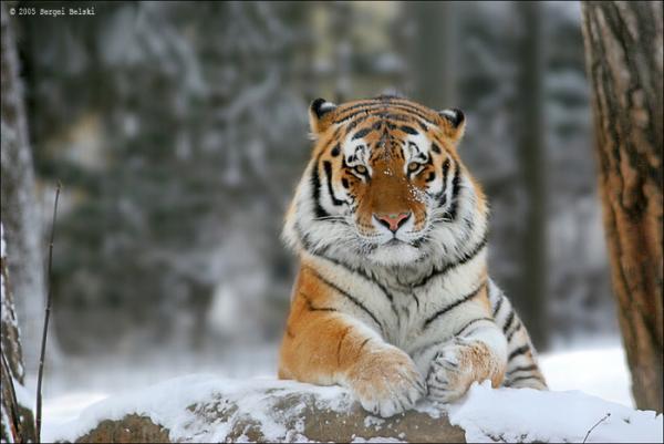
Amur Tiger Many times ago the Amur tiger's range included China, Korean peninsula, Khabarovsk Territory and Primorie Territory. Today the main population of the Amur tigers can be found to the Northeast in the Sikhote Alin mountain range. The Amur tiger population in Russia is about 450 animals. From year to year its number decreases. It is registered in Red Data Book. |
|
|
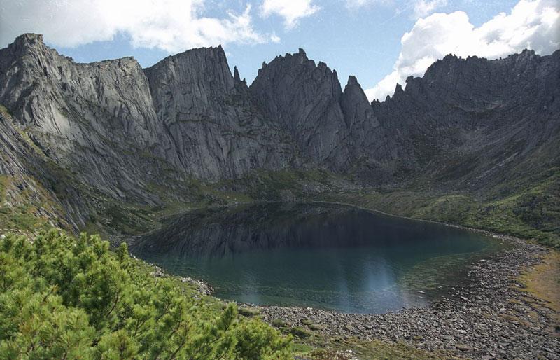
Dusse-Alin mountain range
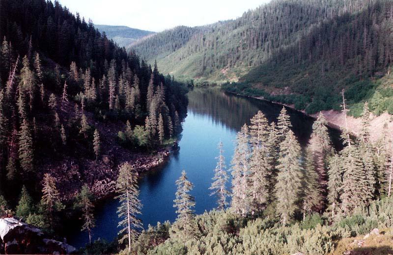
This “lost world” is located in the middle of Khabarovsk region. As in Conan Doyle’s novel, this is a remote mountain plateau, home to a land hidden from human eyes: crystal-clear lakes, beautiful water-falls and unique wildlife.
|
|
|
Shantar Islands A group of fifteen islands that lie in Uda Bay, in the southwestern zone of the Sea of Okhotsk. These islands are located close to the shores of Siberian mainland. Most islands have rugged cliffs, but they are of moderate height; the highest point in the island group is 720 metres. There is no permanent population on the Shantar Islands. The islands are currently uninhabited. |
|
|
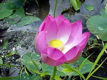
Lotuses This unique plant grows in several lakes in the south of Khabarovsk region and flowers for just a few days. In order to see the lotus blossom, tourists venture into woods and walk up to their knees in water. The lotus, one of the world’s oldest plants, is an object of worship in many parts of Asia.
|
|
|
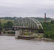
Amur Bridge See Unit VII, Lesson 19. |
|
|
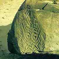
Sikachi-Alian petroglyphs Near the Nanai village of Sikachi-Alian, in 75 kilometers off Khabarovsk there are petroglyphs of masks, animals, anthropomorphic images, birds (over 300 images) made on basalt rocks by the method of deep gutter knock-out. Most ancient of them are dated by Late Stone Age (7-6 millennium B.C.). Sikachi-Alian petroglyphs are older than Egypt Pyramids. |
|
|
Amut lake It is located in Solnechny area. The nearest settlement is the settlement of Gorny. The length of the lake is 960 m, width - 520 m, depth - 18 m. Beautiful landscape and possibility to get there by bus and car transport can give start to development of recreational, cognitive, ecological and scientific tourism in this place. |
6. Describe the flag and coat of arms of Khabarovsk Territory.
7. Discuss 7 Miracles of Khabarovsk Territory. Why did people elect them among other 26?
8![]() .
Watch map № 24. Describe the location of Khabarovsk Territory.
Prove that it is very convenient for the development of economy.
.
Watch map № 24. Describe the location of Khabarovsk Territory.
Prove that it is very convenient for the development of economy.
9. Translate into Russian.