

IV. Answer the questions.
1. Where is the Midlands located?
2. What influenced the industrial development of the Midlands?
3. Is Birmingham a large city?
4. How does the climate affect the development of agriculture in the Midlands?
5. What famous old town is located in Yorkshire?
6. Does steel production play an important role in the development of Scunthorpe?
7. What seaports are located in the Humber?
8. Why does tourism play an important role in North Wales?
9. How have the physical features of Scotland influenced the development of its economy?
10. What city is the main industrial centre of Northern Ireland? Why?
V. Do you remember?
1. What city of the Midlands is twinned to Minsk?
2. The main factor which contributed to the building of Calder Hall.
3. The reason why Edinburgh is called "The Athens of the North".
Transport
T he
easy movement of goods and people is an essential feature of a modern
industrialized country, such as the United Kingdom. Agricultural and
industrial products must be moved to markets and ports, just as raw
materials and labour must be transported to the factories. Within
Britain, these functions are carried out by a complex transport
system that has developed slowly over several centuries.
he
easy movement of goods and people is an essential feature of a modern
industrialized country, such as the United Kingdom. Agricultural and
industrial products must be moved to markets and ports, just as raw
materials and labour must be transported to the factories. Within
Britain, these functions are carried out by a complex transport
system that has developed slowly over several centuries.
Before the 17th century there was little need for rapid communication, because most local areas were relatively self-sufficient in raw materials for industry. But regional specialization and increased industrial output that resulted from the Industrial Revolution demanded more suitable means of transport than had existed previously. Economic interchange between different parts of the country became essential to the development of the country, and new models of transport evolved to meet these needs: the railway and the canal.
During the 20th century needs have changed again, so that emphasis is placed not only upon ease of communications, but also speed of communications. This has been achieved not only by the use of freight aircraft, but the development of high speed motorways.
In the Middle Ages, river transport played a major role in the British internal transport system, because all the large towns of the time were situated on navigable rivers. Moreover, the quality of roads was so bad that attention was turned to river navigation. This emphasis on water transport was increased during the great period of canal construction during the latter part of the 18th century. By 1830 there were about 10,000 kilometers of canals and "improved" rivers in Britain. However, river navigation suffered from a number of problems including silting, summer drought and the fact that a number of industrial areas, including Birmingham, were not on navigable rivers. The construction of the railways after 1830 meant the gradual decline of waterways, many canals were no longer used for commercial traffic, but for pleasure boating.
C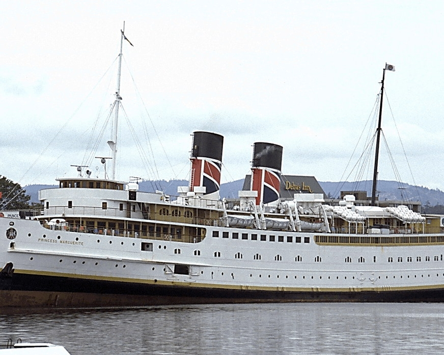 oastal
shipping has also changed within the last century. Once it was the
most important form of transport to move coal from North-East England
to London, but now most coastal shipping is passenger-carrying. Links
are maintained with many of the offshore islands, particularly in
Scotland, by regular passenger ferries which may also carry freight.
oastal
shipping has also changed within the last century. Once it was the
most important form of transport to move coal from North-East England
to London, but now most coastal shipping is passenger-carrying. Links
are maintained with many of the offshore islands, particularly in
Scotland, by regular passenger ferries which may also carry freight.
The impetus for the development of railway communications came from the expanding coal trade of the early 19th century. Railways were speedier, in many respects more flexible and also were a more convenient means of transporting goods to and from the ports in foreign trade, or exporting ports. Most of the early railways were all built to link coalfields with expanding industrial areas. The first public railway, between Stockton and Darlington, was opened in 1825, in northern England.
A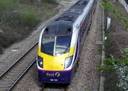 s
industrialization continued the canals were found inadequate to cope
with the volume of traffic and railways were built to cope with the
problem. Gradually railways took the place of the canals, and towns
grew up and developed at railway junctions and along the main lines.
Railways were becoming efficient carriers of passengers, either those
travelling on business or on holiday. By the middle of the 19th
century through rail links had been established between the major
cities and towns of Britain — London, Birmingham, Manchester,
Liverpool, York, Leeds, Newcastle, Brighton, Southampton, Exeter,
Bristol.
s
industrialization continued the canals were found inadequate to cope
with the volume of traffic and railways were built to cope with the
problem. Gradually railways took the place of the canals, and towns
grew up and developed at railway junctions and along the main lines.
Railways were becoming efficient carriers of passengers, either those
travelling on business or on holiday. By the middle of the 19th
century through rail links had been established between the major
cities and towns of Britain — London, Birmingham, Manchester,
Liverpool, York, Leeds, Newcastle, Brighton, Southampton, Exeter,
Bristol.
During the 19th century and the early years of the 20th century the railways were the principal carriers of both freight and passengers. But the invention of the internal combustion engine introduced a rival means of transport — an automobile.
As roads were improved, and motor vehicles became faster, more reliable and more numerous, with the advantage of door-to-door delivery, many railway lines lost traffic and became uneconomic to run. On the longer internal routes, the railways lost passengers to civil airlines. All through the present century they have faced increasing competition from road transport. This has resulted in a decline in the importance of the railways and the closure of many lines and stations. Some of these closures were the inevitable consequence of the way in which the railways were built. For example, during the boom years rival companies built many competing parallel lines between the major cities and, as traffic declined, some of these lines became seriously underused. Such lines were closed.
The pattern of roads in Britain still bears traces of the Roman road network, although the modern network is really a product of the last two centuries. This road system was quite unplanned. Built, in the first place, to link settlements, such roads formed long distance links, which were not the most direct or the most efficient. The real importance of the road system did not emerge until the early 20th century, when the invention of the motor-car created a revolution in industrial transport.
Modern methods of evaluating road requirements for the future have been developed by government planners and a system of motorways linking many parts of Britain was begun in the late 1950s. The development of the fast roads together with the increasing use of large container lorries has meant a rapid rise in road freight transport. More motor vehicles for passengers and lorries direct from the continent began to appear on British roads.
However, many of Britain's roads are not suited to cope with the current volume of traffic. Most of them were designed to handle horse-drawn traffic and are inadequate for modern motor vehicles, especially modern lorries. The increased motor traffic has tended to produce congestion, particularly in towns and cities where several roads may converge, and where congestion has become a daily nightmare for drivers, pedestrians and inhabitants alike.
Overseas communications are inseparable from Britain's trade which is handled at a number of ports. Most of these ports have been involved in trade for several hundred years.
Great Britain has a long tradition as a maritime and trading nation. The country has never been entirely self-sufficient in foodstuffs and raw materials, and must rely on other countries to provide these commodities. In order to pay for these goods Britain must export her manufactured goods to other countries throughout the world. By the end of the 19th century dependence on trade had become so great that Britain was conducting more than one-third of world trade in manufactured goods. Although Britain's share of world trade has declined greatly since that time, on account of competition from other countries, she remains one of the leading commercial nations of the world.
The majority of Britain's ports are situated in the mouths, wide estuaries of rivers. Of great importance for the port activity are tides, when the rising water reaches its maximum mark (high tide). For example, in the port of London during the high tide the water rises to the level of 6 m, in Liverpool — 8.5m, in Bristol — 10m. Due to the high tides many towns which are situated dozens of kilometres from the coast have become sea ports (London — 64 km from the coast, Glasgow — 35, Hull — 32, etc.). The introduction of container traffic has led to an enormous reduction in the amount of time spent loading and unloading ships.
Although the largest British ports serve a variety of purposes, many ports concentrate on one particular activity.
1) The largest ports handling ocean freight trade are London, Liverpool, Hull, Southampton, Glasgow, Bristol.
2) The principal ocean-passenger ports are Southampton, London (Tilbury) and Liverpool.
3) The principal ferry-passenger ports for communications with Europe are Harwich, Dover, Folkestone, Newhaven and Southampton.
4) The most important fishing ports are Hull, Grimsby, Lowestoft, Fleetwood and Aberdeen.
5) Specialized naval ports include Portsmouth and Plymouth.
6) The development of the North Sea oil has given rise to new ports, or oil ports, through which the main traffic of this product passes: Tees, Forth ports, Flotta in Orkney and Sullom Voe in Shetland.
T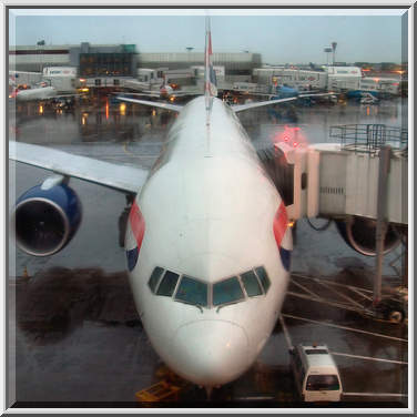 he
most striking development in the field of transport in recent years
has been the growth of air traffic. It handles both freight and
passengers to whom speed is more important than cost. The number of
people who travel by air has increased at a very fast rate.
Practically all major cities and towns of Britain are served by
regular daily flights.
he
most striking development in the field of transport in recent years
has been the growth of air traffic. It handles both freight and
passengers to whom speed is more important than cost. The number of
people who travel by air has increased at a very fast rate.
Practically all major cities and towns of Britain are served by
regular daily flights.
London is served by two chief airports — Heathrow and Gatwick. Heathrow airport handles about seventy-five per cent of all passenger traffic and sixty-five per cent of all freight passing through British airports. It is one of the largest and busiest airports in the world for international travel. It covers an area of more than twenty square kilometres.
Of all airlines operating in the United Kingdom, British Airways is one of the world's leading airlines, and in terms of the passengers carried it is the largest in the world.
Comprehension Check