NP 286(3) Mediterranean and Africa
.pdfCONTENTS LIST |
|
INDEX |
|
|
|
GABON
NOTE:
Terminal is owned and operated by Vaalco Gabon (Etame) Inc.
GAMBA OIL TERMINAL
UNClAD LOCODE: GA GAX
Pilots and Terminal
CONTACT DETAILS: Call: Gamba Marine
Terminal Control Room VHF Frequency: Ch 06; 0612
Telephone: +241 07840095 (Duty Officer, H24) +241 558465 (Office hours)
+241 559657 (AOH) +31(0)703037182 (Office hours)
Fax: +31 (0)70 3037164 (Attn: OLS/4) +241 558577
E·mail: marine-department@shell.com
HOURS: Gamba Marine: 0700-1200 1400-1700 LT
Terminal Control Room: H24
PROCEDURE:
(1) Pilotage is compulsory within the restricted area and is available H24.
(2) Notice of ETA: Vessels should send ETA 96h, 72h, 48h and 24h in advance to Gamba Marine OLS/4 by fax and/or e-mail. The 96h arrival message should include the following:
(a) ETA and intended NOR
(b) Cargo requirement in barrels
(c) Type, number and SWL of bowstoppers
(d) Oil Pollution Certificate details
(e) Last port of call
(f) Owner, operator, charterer, flag, port of registry and year built
(g) SDWT, GT, NRT, LOA, beam and maximum summer draught
(h) Master'sfull name
(i) Address, telephone and e-mail addresses of operators/managers Ol Vessel'scallsign
(k) USCG Identifier for Bills of Lading (if required)
(I) Arrival and departure draughts
(m) Power voltage in pilot'scabin
(n) Segregated ballast tanks (SBT) or clean ballast tanks (CBT)? If CBT, time required for deballasting if not concurrent with loading
(0) Vessel inerted and IG plant fully operational?
(p) Name of agent in Port Gentil
(3) During mooring and loading operations, working channel is VHF Ch 12.
(4) Pilot is the qualified Port Facility Security Officer (PFSO).
(5) Pilot boards at the anchorage (2 n miles NW of the SBM) and remains onboard for the duration of loading in the role of Loading Master.
NOTE:
Terminal Authority is Gamba Marine, Shell Gabon, BP 146, Port Gentil, Gabon.
LUCINA OIL TERMINAL
UNCTAD LOCODE: GA LUC
Pilots and Terminal
CONTACT DETAILS: Call: Banio
VHF Frequency: Ch 08
Telephone: +870 762732450 (Inmarsat mini-M) Fax: +241 550647
+870762732451 (Inmarsat mini-M) E-mail: baniogan64@eikmail.com
sitebanio@ga.perenco.com
89
CONTENTS LIST |
|
INDEX |
|
|
|
GEORGIA
Signal Post
Call: Bat'umi17
VHF Frequency: Ch 16; 13
Port Authority
Telephone: +995(8)22276261 +995(8)222 76958
Fax: +995(8)22276261 +995(8)222 76958
E-mail: bsport@batumiport.com Website: www.batumiport.com
Tugs
VHF Frequency: Ch 09
HOURS: H24
PROCEDURE:
Vessels lying at mooring buoys should maintain a continuous listening watch on VHF
Ch 16.
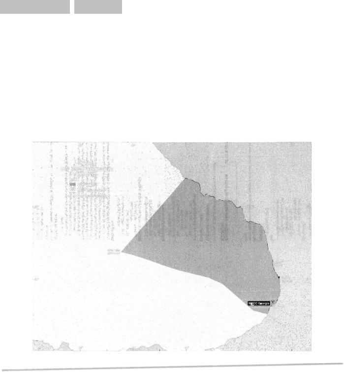
GEORGIA· SHIP REPORTING SYSTEM (GEOREP)
See diagram GEORGIA SHIP REPORTING SYSTEM (GEOREP).
Ship Reporting System
CONTACT DETAILS:
MRCC Georgia (GEOREP Reports)
Telephone: +99522273913
Fax: +995 222 73905
+995 222 73929
Telex: +51 9475392 MRCC G
E-mail: mrcc@maradgeorgia.org
MMSI: 002130100
MRCC Georgia (Enquiries)
Telephone: +995222 73913
Fax: +99522273905
Telex: +51 9475392 MRCC G
E-mail: mrCC@maradgeorgia.org
Maritime Transport Administration of Georgia
Telephone: +99522273917 +995 222 73909
Fax: +99522273929
E-mail: mtag@maradgeorgia.org magheadof@fsc.gov.ge
DESCRIPTION:
(1) GEOREP is operated by MRCC Georgia. Participation in GEOREP is mandatory and cost free and vessels of any nationality, tonnage or type are welcome as long as they are within 1he service of GEOREP.
(2) GEOREP serves to identify and monitor the positions of vessels which participate in the scheme in the area covered by the system. To achieve this vessels within the coverage area provide regular reports. This information is used to maintain achart plot of the vessels'positions. GEOREP is to aid search and rescue operations in that it:
(a) Reduces the time between the loss of a vessel and inniation of search and rescue action in cases where no distress signals are sent out;
(b) Limits the search area for rescue operations; and
(c) Provides up-to-date information on shipping resources available in the vicinity of a casualty.
REPORTING AREA:
The area of coverage of GEOREP is bounded by a line joining the following co-ordinates:
(1) 43°23'·00N4O"00'·50E
(2) 42°24'·00N38°41'·00E
(3) 42°20'·15N39°00'·13E
(4) 42°08'·00N39°50'·50E
(5) 42°02'·00N400 26'·00E
(6) 41 °57'·OON40°42'·OOE
(7) 41 °35'·50N41 °16'·50E
(8) 41 °31'·00N41 °33'·00E
93