

6. Algorithm of inertial navigation system
As an algorithm or formula scheme of a system we can consider such analytical dependences, by means of which the current location of the object is determined on the basis of initial conditions and accelerations, measured in inertial space. Example of a simple algorithm for inertial system with respect to solving the navigation problem in a Cartesian coordinate system is given by dependencies (1). Formulas (1) are converted to relatively simple ones:
 (9)
(9)
where
![]() - the location of primary position, counted from the origin; ;
- the location of primary position, counted from the origin; ;
![]() - the initial speed;
- the initial speed;
![]() - the current position, measured along two orthogonal axes; ;
- the current position, measured along two orthogonal axes; ;
![]() -
acceleration components along the x and y axes, respectively.
-
acceleration components along the x and y axes, respectively.
To solve the navigation problem we need to identify the origin, the initial position of object relative to this point and its initial velocity. The directions along which location change are registered must be installed. Components of acceleration of the object by the chosen coordinate axes should be measured and integrated twice to determine the change in location. Algorithm of real systems, able to implement navigation in relation to the Earth, should contain formula dependences, which reflect the movement of the Earth relative to the inertial space (the angular values - position, velocity, acceleration) and its deviation from the exact form of the sphere.
Depending on the type of algorithm gravitational adjustment members may be functions of angular position. Finally, after measuring the acceleration in relation to the inertial space, calculated changes in the location must be transformed into a corresponding increment of the coordinates on the Earth's surface. In inertial navigation systems, used on aircraft, the origin of the inertial coordinate system is the Center of the Earth, but dimensioning to the Earth surface is very diverse in these systems. In this case, the coordinate systems are chosen with regard to: the technical characteristics of the object that uses the inertial system; the required accuracy and methods of alignment; size, weight and cost of the system; characteristics of the output signals and relationship with the equipment.
Coordinate systems are conveniently divided into three classes: classical coordinate system, coordinate systems, free in azimuth; exotic coordinate system (for example, one-pole CS). Classical coordinate systems are characterized by angular velocity of the platform, determined by the terms of the need to maintain coincidence between the axes of the platform and the axes of coordinates fixed on the Earth or the surface, which represents the Earth. Free in azimuth coordinate systems are called so because they have zero angular velocity of the platform in the direction of zenith.
Unipolar system has some characteristics of each of these coordinate system classes. In general, each classical coordinate system corresponds to the system, free of azimuth. Thus, in the inertial system I-11 of airplane Il-62 classic geographic coordinate system is used, and free of azimuth system, corresponding to the mentioned classical one, is used in the inertial heading gyrovertical of an airplane Il-86.
The point of transition to a free in azimuth coordinate system is connected to the simplification of the system due to the fact that necessity of creation of variable signal, applied to the moment sensor of azimuth gyroscope, is excluded. The distinguishing characteristic of the azimuth-free systems is the angular mismatch between the axes of the coordinate system and axes of the platform.
7. COMPUTING DEVICES FOR INERTIAL SYSTEMS
Computing device that is used in inertial systems is primarily intended for conversion of measured accelerations in the current coordinates of the aircraft. Therefore, the form of equations, with the help of which the calculations are made, determines the requirements for the computing device.
It is important to note that in order to solve the navigation tasks it is necessary to perform a large number of operations of differentiation and integration of current values, as well as the formation of trigonometric functions.
But this is only part of the problem of computer device design for inertial navigation system. Another part of the challenge is to develop management and communication between the inertial components (accelerometers and gyroscopes of the platform), as well as the development of system for data input and output information to consumer (pilots or navigators).
Let’s
consider the simple navigation task in the coordinates
![]() (longitude) and
(latitude) when object is moving at constant altitude.
(longitude) and
(latitude) when object is moving at constant altitude.
For the spherical Earth equations (9) are valid in the form of:
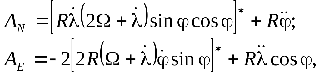 (10)
(10)
where R is the distance from the object to the Earth center taken as constant.
The
calculations in such navigation system consist in subtracting of
members, mentioned in equations (10) with stars, from magnitudes
![]() and
and
![]() produced by accelerometric devices. The resulting differences are
divided by R
and
produced by accelerometric devices. The resulting differences are
divided by R
and
![]() ,
then after double integration the increments of longitude and
latitude used for positioning are obtained.
,
then after double integration the increments of longitude and
latitude used for positioning are obtained.
The first inertial navigation system used the analogue computing devices. Requirements to ensure the accuracy of calculations with the extended long-range flights, as well as the lack of flexibility of electromechanical computing devices have led to the transition to digital computing device. In digital computing devices the required accuracy of calculations is provided by the increase in the number of bits. Reconfiguring computer from one type of equations to the other can be achieved by changing the program, facilitating the control of the whole system.
In the family of digital computing devices, there are two different types of computers. One of them is working by increments and is called as digital differential analyzer, and another type is integer, usually called as general-purpose computer.
Currently, a computer is a combination of the two mentioned types and more fully meets the nature of calculations performed in the inertial navigation system.
8. GEOGRPHICALLY ORIENTED PLATFORM. ALIGNMENT OF THE PLATFORM
Let’s consider platform, controlled in the way that its axes are always oriented on the directions east (E) – north (N) – zenith (Z). The scheme, shown on fig.12, can help to explain operating principle of such platform and volume of calculations, required for it in navigation purposes.
