

4. The errors of the platform with period of oscillation 84.4 min
To
be sure in the advantages of the platform, which is set on the
Schuler period (84.4 min), let’s consider the case, when the base
of the platform is unmovable and it is placed with the initial
slope![]() .
(fig.9). With help of the figure we may imagine how variables change
with the course of time
.
(fig.9). With help of the figure we may imagine how variables change
with the course of time
![]() и
и
![]() , (3)
, (3)
which
are correspond to the given case. The value![]() ,
which is accepted by integration of the measured value
,
which is accepted by integration of the measured value
![]() ,
can be called as velocity error, and value
,
can be called as velocity error, and value
![]() - as travel error. Because of the slope
,
the accelerometer shows negative acceleration at the beginning. That
is why after integration values
and
appear, which differ from zero. These values are errors, because the
base of the platform is unmovable in fact. The platform oscillate
with Schuler frequency
- as travel error. Because of the slope
,
the accelerometer shows negative acceleration at the beginning. That
is why after integration values
and
appear, which differ from zero. These values are errors, because the
base of the platform is unmovable in fact. The platform oscillate
with Schuler frequency
![]() ,
and its angular slope is
,
and its angular slope is
![]() (4)
(4)
By
the integration of (3) at initial data
![]() ,
,
![]() we obtain the following equations:
we obtain the following equations:
![]() ;
;
![]() ; (5)
; (5)
![]() .
.
These
periodical errors are shown by full line on the figure 9. On the
fig.9 by dash line the functions are shown, which are received in
case when the platform is not set on the Schuler period and has the
acceleration
![]() .
Let’s consider that
.
Let’s consider that
![]() that is equal to the initial error
that is equal to the initial error
![]() ,
so we get:
,
so we get:
![]() . (6)
. (6)
Here
the velocity error increases linearly and travel error increases
proportional to the time squared that is why it’s considerably
greater, than the similar errors in the platform with Schuler
setting. If we consider that
![]() ,
then from equation (6) we’ll get, that in an hour the travel error
will be 28 km , but it is known from (5), that the maximal error will
not exceed 6 km. After 3 hours the error due to (6) increases up to
225 km. This example proves that at absence of Schuler correction it
is impossible to get available inertial system.
,
then from equation (6) we’ll get, that in an hour the travel error
will be 28 km , but it is known from (5), that the maximal error will
not exceed 6 km. After 3 hours the error due to (6) increases up to
225 km. This example proves that at absence of Schuler correction it
is impossible to get available inertial system.
Given
example applies to the case when accelerometer error
![]() appears, for example, due to initial platform slope (alignment
error). Also there are errors, which are caused by the gyro drift and
shown in the platform drift
appears, for example, due to initial platform slope (alignment
error). Also there are errors, which are caused by the gyro drift and
shown in the platform drift![]() owing
to the action of follow-up system.
owing
to the action of follow-up system.
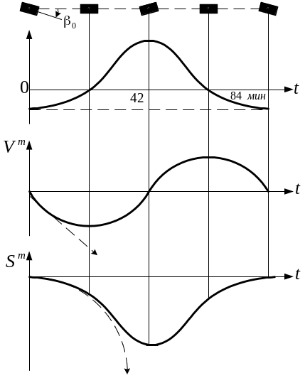
Fig. 9 The acceleration measuring errors, errors of speed and path, which may appear at the platform initial deviation by the angle . The dotted lines correspond to the platform, which has not any pendulum correction.
In
this case the platform, which has the oscillation system properties
and set on the frequency
![]() ,
moves according to the law:
,
moves according to the law:
![]() (7)
(7)
From
this follows, that if the platform base is unmovable relative to the
Earth and
![]() ,
the system errors will be:
,
the system errors will be:
![]() ;
;
![]() ;(8)
;(8)
![]() .
.
In this case, the average value of the travel error increases in proportion to time. The average error is overlaid by the oscillation with the period 84 min. This conclusion proves that travel errors of the inertial system highly depend on the gyro quality. We can show that travel error of the platform, without Schuler setting, increases proportionally to third degree of time.
5. THE NAVIGATIONAL COORDINATE SYSTEMS in INERTIAL SYSTEMS. THE FORM of the EARTH
In previous discussions the Cartesian coordinate system was used for inertial navigation. In practice choice of coordinate system is very important for the algorithm creation of the inertial system.
Before choosing the coordinate system, it is necessary to consider two questions. At first, let’s estimate the difficulties of the determination of that part of the value measured by accelerometer, which is connected with measurement of X and Y in rectangular coordinate system or with measurement R and Q in polar coordinate system. Secondly, let’s count computing work content of the problem of the exact orientation maintenance of the platform with accelerometers and base directions, implemented by gyroscopes. With reference to the flat Earth case errors were considered, which appear in consequence of deflection of the platform in azimuth and in horizontal plane. Nature of these errors’ change are greatly varies if inertial system is considered with reference to spherical Earth. That is why we need to get acquainted with the features of the Earth form, which are to take into account for simplification of the inertial system operation.
The Form of the Earth. When designing navigational inertial system it is necessary to take the certain assumptions, due to which points and lines in space can be uniquely connected with points and lines on the terrestrial surface. These assumptions are closely bound with analytical features of size, form and gravity field of the Earth.
Gravity field of the Earth is characterized in each point by vector of power, referred to unit of the mass, which acts upon investigated body, placed in the given point, and which is defined only by attraction of the Earth mass. The power field determined as amount of gravitation field and field, acting upon bodies, which revolve together with the Earth, is called as gravity field.
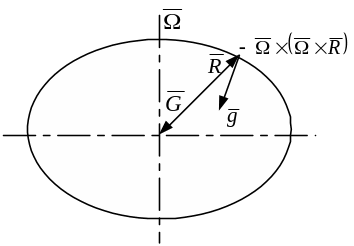
On
fig. 10 flat spheroid is presented. Here we can see correlation
between vector of gravitation field
![]() and vector of gravity power
and vector of gravity power
![]() .
In condition that geopotential
.
In condition that geopotential
![]() ,
Equipotential
surfaces of the gravity field are ellipsoids with the wrong form. One
of the equipotential surfaces, which is most close to average sea
level, is chosen as initial. This surface is identified as geoid.
Geoid has not exact determined mathematical form, which can change
from point to point in dependence on change of density of the
terrestrial cortex. The normal to geoid
in any point is defined by direction of plumb-in line, which is
called as astronomical vertical, cause it gives the coordinate basic
origin when under stellar observations.
,
Equipotential
surfaces of the gravity field are ellipsoids with the wrong form. One
of the equipotential surfaces, which is most close to average sea
level, is chosen as initial. This surface is identified as geoid.
Geoid has not exact determined mathematical form, which can change
from point to point in dependence on change of density of the
terrestrial cortex. The normal to geoid
in any point is defined by direction of plumb-in line, which is
called as astronomical vertical, cause it gives the coordinate basic
origin when under stellar observations.
The geoid form is approximated by ellipsoids, described with sufficient mathematical accuracy and built on base of the geodetic measurements. Under modern requirements to navigation the presentation of geoid as flat sphere, when radius in equator plane on 22 km more than arctic radius, turns out to be rough. So at present rather more accurate reference ellipsoids are used.
In USSR the Krasovsky ellipsoid has found using, equatorial radius of which is 6378245 m, arctic one is 6356863 m, and ellipticity is 0,3352%. Geoid and reference-ellipsoid approximately correspond to each other, however geoid sometimes towers over ellipsoid (in mountains), but sometimes is lowered below level of the ellipsoid (in oceans). The most important influence on accuracy of inertial navigation is caused not by gravity anomalies, but deviations from vertical, with which anomalies are closely bound.
|
|
Fig. 10 Relation between gravitation field vector and gravity force vector |
Fig.
11 Geographical
|
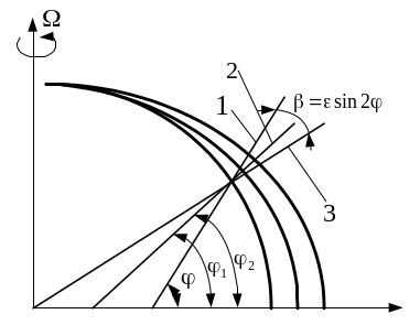
An angle between normal to geoid and normal to reference-ellipsoid is called as deflection of vertical. These deflections in mountain regions can reach up to several tens of the angular seconds. So there is responsible problem to choose the type of reference-ellipsoid, especially using inertial systems in long-range flights, because compensation errors of the Earth gravity can considerably increase. The geocentric 1, gravity 2 and geographical 3 verticals are represented on fig. 11
.