

Text 5 naviagtion system – ins
Navigation across oceans and in areas where few ground-based navigation aids exist is normally achieved by using an Inertial Navigation System (INS), In use an INS is given the aircraft's start position, it then senses all movements the aircraft makes and continuously updates the position of the aircraft. Normally triplicated systems are used to eliminate the possibility of error and ground based radio aids are used, where available, to update the positional accuracy which has a tendency to drift by a mile or two an hour.
Naviagtion system – ndb
Non Directional Beacons (NDB) transmit signals (200-1720KHz) in all directions and are point source navigational aids. Their range is normally around 40 miles. They are generally used is a locator beacon to provide airfields with holding facilities and a non-precision approach. With higher power their range can be around 150Nm when they can act as an en route navigational aid. The use in the en route role is only common in remote areas and areas of low traffic density.
triplicated [triplikeitid]утроенный
Text 6 navigation system – landing aids
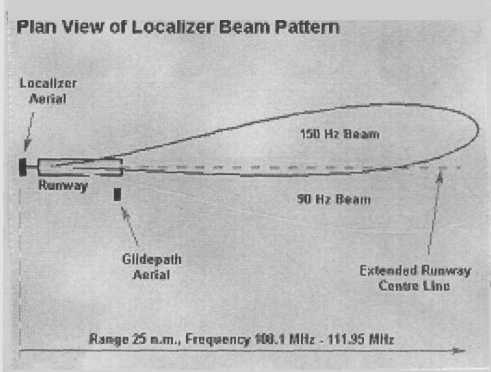
The localizer (VHF 108-112MHz, range 25NM) provides guidance in azimuth and the glidepath (UHF 328 335 MHz, range 10NM) provides guidance in elevation.
In use the pilot establishes the aircraft on the final approach track (defined by the localiser) at distance of around 12 Nm and a height of 3000 ft. At this point the aircraft is below the approach slope defined by the Glidepath. When the pilot intercepts the Glidepath descent is started and the localiser and Glidepath are followed down to the pilots approach minima.
The pilot determines the distance from touchdown by fixed distance marker beacons (75MHz) located on the extended centre-line about 3.5NM (outer marker) and 3500ft (middle marker) from the runway threshold. Each beacon radiates a characteristic and easily identifiable signal. These provide fixed points where distance to go can be checked against the aircraft height, thus confirming the accuracy of the altimeter setting.
guidance [7gaidEns]наведение
TEXT 7
RADIO NAVIGATION AIDS - VOR/DME
Apart from taking their bearings from the stars, how do pilots navigate? The answer, of course, is in the use of radio navigation aids. There are a variety of different types of radio navigation aids but here we shall discuss VOR and DME only.
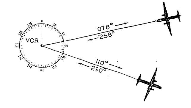
VOR and DME are often located at the same site. They operate on VHF and UHF respectively and, as a consequence, are not affected by static or other interferences. The maximum range of VOR is about 200 nautical miles. By flying VOR the pilot ensures he is flying directly to the station. Also by measuring his radials from more than one VOR station, a pilot can check his position.
The function of DME, which is short for Distance Measuring Equipment, is, as its title describes, to measure distance.
The DME measures, electronically, the time it takes for a signal, transmitted from an aircraft interrogator, to reach the ground base station transponder, and return. This elapsed time is converted to miles and appears on a digital indicator on the flight deck. The indicator actually seems to rapidly count the number of miles between the aircraft and the station giving the pilot a continuous digital reading of how far he is from, or to, a station.
With the many VOR/DME stations along his route, a pilot can make good his desired track; is constantly aware of his distance to or from a DME station; or, by using two VOR radials, establish his exact position.
bearing [7bBEriN]пеленг
measure [7me3E]измерять
elapse [i7lXps]истекать (о времени)
convert [kEn7vE:t]преобразовывать