

2kurs_3sem_ftk (1)
.pdfЗадание для заочников ФТК 2 курс 3 семестр
I. Reading materials Text A. Highway Design. The road in plan.
Highways are designed for the haulage of goods and passengers with a minimum of effort and at low cost. These requirements are known to be satisfied best if the road could be built along the shortest distance, i.e. straight line between two given points. However, the building of a road along the shortest distance is precluded by the topography of the land (mountains, ravines, etc.), water obstacles (marches, lakes, rivers),as well as the necessity to lay the road through certain intermediary points - places adjoining towns, places conveniently located for crossing rivers, railways or other highways.
The necessity to locate the crossing where the river is straight and affords a convenient approach with shallow banks, the desirability of bypassing an inhabited locality and the necessity to avoid the crossing of a ravine dictate the location of the road along the broken line in the plan rather than along the shortest and most direct (airline) route. For the convenience of passage of motor vehicles, it is necessary to inscribe circular arcs of adequate radius at changes in direction.
Such a line, marked, on the land and located along the road centre line called the route. The graphical representation of the line of the route, projected on a horizontal plane and drawn to a given scale is called the plan of the route.
Any deviation of the direction of the route is determined by the deflection angle.
Conditions for the high-speed driving of vehicles are expected to deteriorate on curved sections, especially on bends of email radius. When moving along a curve, the motor vehicle is expected to be subjected to a centrifugal force, the effect of which tends to displace it off the road, and to prejudice the car's stability. Also, the driver's road visibility is impaired; in some cases, the planting at the side of the road have to be cleared, or the faces of cuttings set back in order to provide safe visibility, and the traffic speed is restricted.
However, excessively long straight stretches of road, through monotonous surroundings, are reported to fatigue the driver and the passengers, especially on long Journeys; Periodic insertions of horizontal curves of modest curvature are known to improve driver's attention and promote the safety of traffic.
1.Give English equivalents for the following words and word combinations. (Work in pairs).
1.С минимальной затратой усилий и при низкой стоимости. 2.Прямая линия между двумя данными точками. 3. Топография местности. 4. Места, примыкающие к городам. 5.Удобный подход с пологими берегами. 6. По ломаной, линии в плане. 7. Вписывать круговые дуги соответствующего радиуса. 8. Отмеченная на местности и расположенная по оси дороги. 9. Графическое изображение. 10. Вычерченная в заданном масштабе. 11. Криволинейные участки. 12. Закругления небольшого радиуса.
13.Двигаясь по кривой. 14. Подвергаться центробежной силе, 15. Сместить автомобиль с дороги. 16. Нарушить устойчивость автомобиля на дороге. 17. Ухудшить видимость дороги. 18. Убирать зеленые насаждения.
2 Answer the questions.
1. What information does this text carry? 2. What are highways designed for? 3. How are these requirements satisfied? 4. What precludes the building of a road long the shortest distance? What dictates the location of the road along the broken line of the plan? 5. What is called the route? 6. What is the plan of the route? 7. What is deflection angle? 8. What deteriorates conditions for high-speed driving of vehicles on curved sections and on bends of small radius? 9. What should be done to promote the safety of traffic?
3.Define the functions of the Infinitives in the following sentences. Translate these sentences.
a)1. Cement is known to have a number of advantages over traditional materials for it can be easily laid, compacted and shaped. 2. This type of binder is reported to be very sensitive to weather conditions. 3. Twelve bridges are expected to be constructed on this length of the motorway. 4. The maximum traffic intensity for one lane is assumed to be 250 vehicles per hour. 5. The experts are reported to be studying the materials to be used in road construction.
b)1. This test seems to prove the suitability of this type of pavement. 2. This material proved to be very valuable in road pavements. 3. Cement proved to be the best material in the road construction.
c)1. This road is unlikely to be completed in the nearest future. 2. The road to be built in this destruct is likely to meet all modern requirements.
4.Transfer the sentences from active into passive voice.
1.We must build the road along the shortest distance.
2.We inscribe circular arcs of adequate radius at changes in direction.
3.They restricted the traffic speed.
4.Periodic insertions of horizontal curves improve drivers attention.
5.They located the crossing where the river was straight.
5.Fill in the words and translate the sentences use only 5 words: investigations, available, natural, roads, slopes, earthworks, construction.
1.We expect these local materials to be used in the … of new roads.
2.These methods will enable full … of local materials to be carried out.
3.To enable this test to be carried out successfully it will be necessary to examine the data....
4.Modern mechanized methods employed for… permit a stable roadbed to be built.
5.They have approved the plan which will enable the reconstruction of both primary and secondary … to be completed.
Text B. Elements of road profile.
The section of a road made by a vertical plane along its centre line is termed a profile.
A profile shows the extent of longitudinal gradients of various road sections, and the relation of the level of the carriageway to existing ground level.
The rate of rise or fell of the longitudinal gradient is one of the most important characteristics of a motor road. In dry weather light passenger and freight vehicles should be able to negotiate short stretches of road having a comparatively steep gradient (over 1 in 10).
In the case of combination vehicles, or where the road surface is dirty and slippery, the limiting negotiable gradient is appreciably gentler.
The natural land slopes often exceed permissible gradients and do not enable the effective operation of motorized transport to be realized. In such cases the road gradient-is made less steep than the slope of the ground by cutting into the shoulder of the rise or, alternatively, by forming embankments for the crossing of valleys or marshy ground.
When the road surface is situated below the land surface because the ground has been excavated, the road is said to be in a cutting. Places where the road is higher than natural ground surface, i.e., where an artificially filled bed has been produced, are termed embankments. Because of the building of embankments and cuttings the road levels do not correspond to the ground surface levels.
The difference between the ground elevation and the grade elevation (or formation line), which determines the height of the embankment to be filled in or the depth of the cutting to be excavated is called the working height or depth (or elevation difference).
The graphical representation of the profile is one of the main drawings, on which the construction of the road is based.
The Drawing of the profile has to conform strictly with established rules.
Text C. Road engineering
Since the beginning of the 20th century, as the automobile and truck have offered ever higher levels of mobility, vehicle ownership per head of population has increased. Road needs have been strongly influenced by this popularity and also by the mass movement of people to cities and thence to suburban fringes—a trend that has led to increasing travel needs and road congestion and to low-density cities, which are difficult to service by public transport. Often the building of new roads to alleviate such problems has encouraged further urban sprawl and yet more road travel. Long-term solutions require the provision of alternatives to car and truck transport, controls over land use, and the proper pricing of road travel. To this end, road managers must be concerned not merely with lines on maps but also with the number, type, speed, and loading of individual vehicles, the safety, comfort, and convenience of the raveling public, and the health and welfare of bystanders and adjoining property owners.
Ideally, the development of a major road system is an orderly, continuous process. The process follows several steps: assessing road needs and transport options; planning a system to meet those needs; designing an economically, socially, and environmentally acceptable set of roads; obtaining the required approval and financing; building, operating, and maintaining the system; and providing for future extensions and reconstruction.
Road needs are closely associated with the elative location of centres of population, commerce, industry, and transportation. Traffic between two centres is approximately proportional to their populations and inversely proportional to the distance between them. Estimating traffic on a route thus requires a prediction of future population growth and economic activity, an estimation of their effects on land use and travel needs,
and knowledge of any potential transport alternatives. The key variables defining road needs are the traffic volumes, tonnages, and speeds to be expected throughout the road's life.
Once the traffic demand has been estimated, it is necessary to predict the extent of the road works needed to handle that traffic. A starting point in these calculations is offered by surveys of the origins, destinations, and route choices of present traffic; computer models are then used i estimate future traffic volumes on each proposed route. Estimates of route choice are based on the understanding at most drivers select their estimate of the quickest, shortest, or cheapest route. Consideration in planning is so given to the effect of new traffic on existing streets, ads, and parking provisions.
Where feasible, the next step in planning a road sys-m is to refine the selected route to a narrow corridor, le various alignment options are drawn, considering the cal terrain and conditions. The economic, social, and environmental benefits and costs of these options are discussed with relevant official and community groups until acceptable specific route is determined.
Text D. Road design.
Alignment and profile. After a route has en selected, a three-dimensional road alignment and its associated cross-sectional profiles are produced. In order reduce the amount of earth to be moved, the alignment is adjusted where practical so that the earth to be excavated is in balance with the embankments to be built, imputers allow many options to be explored and realistic
views of the future road to be examined.
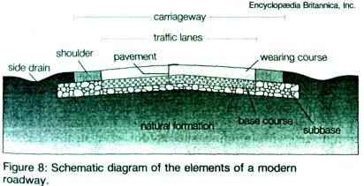
In order fully to understand the design stage, a few standard terms must be defined (see Figure 8). A traffic lane is the portion of pavement allocated to a single line of vehicles; it is indicated on the pavement by painted longitudinal lines or embedded markers. The shoulder is a strip of pavement
outside an outer lane; it is provided for emergency use by traffic and to protect the pavement edges from traffic damage. A set of adjoining lanes and shoulders is called a roadway or carriageway, while the pavement, shoulders, and bordering roadside up to adjacent property lines is known as the right-of-way.
In order to maintain quality and uniformity, design standards are established for each functional road type. The number of traffic lanes is directly determined by the combination of traffic volume and speed, since practical limits on vehicle spacing means that there is a maximum number of vehicles per hour that pass through a traffic lane. The width of lanes and shoulders, which must strike a balance between construction cost and driver comfort, allows the carriageway width to be determined. Standards also specify roadside barriers or give the clear transverse distances needed on either side of the carriageway in order to provide safety in the event that vehicles accidentally leave the carriageway. Thus it is possible to define the total right-of-way width needed for the entire road, although intersections will add further special demands.
Design standards also help to determine the actual alignment of the road by specifying, for each design speed, the minimum radius of horizontal curves, the maximum vertical gradient, the clearance under bridges, and the distance a driver must be able to see the pavement ahead in order to stop or turn aside.
II. Grammar
1. Подготовиться к лексико-грамматическому тесту по текстам:
« Pavement », « Kinds of pavements »
2. Повторить грамматический материал к лексико-грамматическому тесту:
1.Неличные формы глагола: инфинитив, причастие, герундий.
2.Употребление местоимения it и one. Усилительная конструкция it is… that.
3.Основные типы придаточных предложений. Союзное и бессоюзное подчинение
III. Tests.
Text 1. Pavement.
Road traffic is carried by the pavement, which in engineering terms is a horizontal structure supported by in situ natural material. In order to design this structure, existing records must be examined and subsurface explorations conducted. The engineering properties of the local rock and soil are established, particularly with respect to strength, stiffness, durability, susceptibility to moisture, and propensity to shrink and swell over time. The relevant properties are determined either by field tests (typically by measuring deflection under a

loaded plate or the penetration of a rod), by empirical estimates based on the soil type, or by laboratory measurements. The material is tested in its weakest expected condition, usually at its highest probable moisture content. Probable performance under traffic is then determined. Soils unsuitable for the final pavement are identified for removal, suitable replacement materials are earmarked, the maximum slopes of embankments and cuttings are established, the degree of compaction to be achieved during construction is determined, and drainage needs are specified.
In a typical rural pavement, the base course provides the required supplement to the strength, stiffness, and durability of the natural formation. Its thickness ranges from 4 inches (10 centimetres) for very light traffic and a good natural formation to more than 40 inches (100 centimetres) for heavy traffic and a poor natural formation. The subbase is a protective layer and temporary working platform sometimes placed between the base course and the natural formation.
The properties of the base course material are usually determined by laboratory tests, although field tests are sometimes conducted to check that the construction process has achieved the designer's intent. Designers typically consider the possibility of structural failure resulting from a single overload and also from damage accumulating under the passage of many routine loads. Both of these types of failure are almost entirely caused by trucks.
Text 2. Kinds of pavements
Pavements are called either flexible or rigid, according to their relative flexural stiffness. Flexible pavements have base courses of broken stone pieces either compacted into place in the style of McAdam or glued together with bitumen to form asphalt. In order to maintain workability, the stones are usually less than 1.5 inches in size and often less than 1 inch. Initially the bitumen must be heated to temperatures of 300°-400° F (150°-200°C) in order to make it fluid enough to mix with the stone. At the road site a paving machine places the hot mix in layers about twice the thickness of the stone size. The layers are then thoroughly rolled before the mix cools and solidifies. In order to avoid the expense of heating, increasing use has been made of bitumen emulsions or cutbacks, in which the bitumen binder is either treated with an emulsifier or thinned with a lighter petroleum fraction that evaporates after rolling. These treatments allow asphalts to be mixed and placed at ambient temperatures.
The surface layer of a flexible pavement protects the underlying base course from traffic and water while also providing adequate tire friction, generating minimal noise in urban areas, and giving suitable light reflectance for night-time driving. Such surfaces are provided either by a bituminous film coated with stone (called a spray-and- chip seal) or by a thin asphalt layer. The spray-and-chip seal is used over
McAdam-style base courses for light to moderate traffic volumes or to rehabilitate existing asphalt surfaces. It is relatively cheap, effective, and impermeable and lasts for about 10 years. Its main disadvantage is its high noise generation. Maintenance usually involves a further spray coating with bitumen. Asphalt surfacing is used with higher traffic volumes or in urban areas. Surfacing asphalt commonly contains smaller and more wear-resistant stones than the base course and employs relatively more bitumen. It is better able to resist horizontal forces and produces less noise than a spray-and-chip seal.
Rigid pavements are made of portland cement concrete. The concrete slab ranges in thickness from 6 to 14 inches. It is5 laid by a paving machine, often on a supporting layer that prevents the pressure caused by traffic from pumping water and natural formation material to the surface through joints and cracks. Concrete shrinks as it hardens, and this shrinkage is resisted by friction from the underlying layer, causing cracks to appear in the concrete. Cracking is usually controlled by adding steel reinforcement in order to enhance the tensile strength of the pavement and ensure that any cracking is fine and uniformly distributed. Transverse joints are sometimes also used for this purpose. Longitudinal joints are used at the edge of the construction run when the whole carriageway cannot be cast in one pass of the paving machine.
In places where the local natural material is substandard for use as a base course, it can be "stabilized" with relatively small quantities of lime, portland cement, pozzolana, or bitumen. The strength and stiffness of the mix are increased by the surface reactivity of the additive, which also reduces the material's permeability and hence its susceptibility to water. Special machines distribute the stabilizer into the upper 8 to 20 inches of soil.
IV. Topics.
1. Roads of Belarus
Belarus is fifteenth among countries with developed network of motorways by density of public roads per one square kilometer and twelfth by their length per one thousand of inhabitants
BACKGROUND
More than four centuries ago the first documents( statuses) for the state regulation of public roads and traffic rules were introduced in Belarus. In XVIII-XIX the Belarusian roads reached the European level. During the Soviet times a large-scale road construction ensured the creation of optimum network of motorways. Presently, having 207,600 square kilometres of territory and 10.5 million inhabitants, Belarus accounts for 53,500 kilometres of public roads. More than 67% of them are concrete or asphaltic concrete, 1,830 km of roads have four or more traffic lanes. The core of Belarusian motorway network is republican highways 16,382 km long.
The main government document that sets out economic, legal and administrative principles of governing the country's system of motorways is the 1994 Law on Motorways. The Committee for Motorways under the Belarusian Transport Ministry oversees the branch that is financed from the state budget road fund.
Transeuropean Highways
The geographical situation of Belarus has predetermined its role of a transit state. The main Belarusian highway Minsk-Moscow was built before the World War II. In 70s the highway was extended to Brest within the project of large-scale construction timed to 1980 Moscow Olympics.
After the break-up of the Soviet Union, the Belarusian motorways became an essential part of the European transportation network. At the present, the major Belarusian highway is Ml (E30 by European classification). It links West Europe countries wiih Russia, crossing Poland and Belarus (606 km). In 1994 the country started the project of Ml modernization, funded with loans of European financial organizations. By 1998 reconstruction of the first stretch of the highway 234 km long was completed. Upgrading and improvement other parts are in progress.
Ml highway makes also a part of the Crete Corridor 11 that is considered by the European Union a priority transportation route due to the significance of East-West transport flows through it.
Another important Belarusian highway is M8 that is a part of the Crete Corridor IX and links Russia with Ukraine through Belarusian cities of Vitebsk and Gomel. The highway is 456 km long.
The 468 km highway Gomel-Vilnius-Klaipeda plays an important role in the Crete Corridor IXB, linking Russia and Ukraine with the Baltic states.
Management
Belarus' road maintenance system had been finally shaped in 1998. State-run companies (called "Avtodor") distribute government orders among companies of different ownership thus making it possible to use the allocated funds efficiently and exercise control over fulfillment of road maintenance contracts. Magistralavtodor oversees maintenance of M highways which are 4,200 km long. Local motorways are run by six Regional Associations which are subordinated to local governments. The road branch of the country employs more than35.000 people.
2. The Speciality "Highways"
The Government of our Republic pays great attention to the road construction industry. The industry is developing at a rapid rate. The network of highways with hard pavements is increasing annually in our Republic; half of them are highways with advanced pavement. In the State Programme "Roads of Belarus" it is envisaged to secure communication between large economic centres of our country, to extend the construction of rural roads, to improve the quality of construction, maintenance of roads and special attention should be paid to the traffic safety.
The Belarusian National Technical University trains road engineers. The speciality "Construction of Motor Roads and Airfields" was organized in 1958. It is one of the leading specialities at the Department of Transport .Communications.
In the first two years the students of this speciality study many general subjects necessary for a skilled and allround educated engineer. Specialization begins in the third year when the students begin to study designing, construction and maintenance of roads.
Having acquired theoretical knowledge the students have their practical training at the University laboratories, construction sites and different enterprises connected with their future speciality.
Much attention is paid to the scientific and research work of the students of this speciality. They carry out research work according to agreements with different enterprises under the leadership of the leading lecturers
of the Department. Their research work is connected with problems of road construction materials, utilization of waste materials in road construction, the problem of road design in conjunction with road safety, etc. This kind of work helps future engineers to combine theoretical knowledge with practice.
Specialists in construction of motor roads and airfields are in great demand. Graduates of this speciality may deal with designing, construction or maintenance of roads. They may work as designers, constructors or maintenance engineers at designing offices, on construction sites or at different maintenance offices respectively.
Every year about one hundred and fifty road engineers graduate from the University and the main task of the students is to do their best to become highly qualified specialists.
V. Vocabulary |
|
Words and word combinations to be remembered: |
|
l. the road in plan |
дорога в плане |
2. haulage |
перевозки |
3. preclude |
не допускать |
4. ravine |
овраг |
5. intermediary |
промежуточный |
6. afford |
давать возможность |
7. broken line of the plan |
ломаная линия в лане |
8.rather than |
а не |
9. inscribe |
вписывать |
10. adequate |
соответствующий |
11. centre line |
ось |
12. route |
трасса |
13. project |
спроектировать |
14. deviation |
отклонение (изменение) |
15. deflection angle |
угол поворотa |
16. deteriorate |
ухудшаться |
17. curved section |
криволинейный участок |
18. bend |
закругление |
19. to be subject to |
подвергаться |
20. prejudice |
нарушать |
21. visibility |
видимость |
22. face |
откос (здесь) |
23. to set back |
срезать |
24. fatigue |
утомлять |
25. curvature |
кривизна |
Words and word combinations to be remembered: |
|
1. elements of road profile |
элементы профиля дороги |
2. section |
сечение |
3. vertical plane |
вертикальная плоскость |
4. profile |
профиль |
5. longitudinal gradient |
продольны уклон |
6. level |
уровень |
7. existing ground level |
уровень земли |
8. the rate of rise or fall |
степень подъема (спуска) |
9. negotiate |
преодолевать |
10. limiting negotiable gradient |
предельный преодолеваемый уклон |
11. natural land slopes |
естественные склоны |
12. permissible |
допустимый |
13. excavate |
вынуть, выбрать |
14. cut ting |
вышка |
15. artificially filled bed |
отсыпанное полотно |
16. embankment |
насыпь |
17. ground elevation |
отметка земли |
18. grade elevation (formation line) |
отметка земполотна |
19. working height or depth (elevation difference) |
рабочая отметка |
20. conform with |
соответствовать |