

Financing
Financing road building was a Roman government responsibility. Maintenance, however, was generally left to the province. The officials tasked with fund raising were the curatores viarum, in which you can see the English word, curator. They had a number of methods available to them. Private citizens with an interest in the road could contribute to its repair. High officials might distribute largesse to be used for roads. Censors, who were in charge of public morals and public works, were expected to fund repairs with their own money. Beyond those means, taxes were required.
The beauty and grandeur of the roads might tempt us to believe that any Roman citizen could use them for free, but this was not the case. Tolls abounded, especially at bridges. Often they were collected at the city gate. Freight was made heavier still by import and export taxes. These were only the charges for using the roads. Costs of services on the journey went up from there.
Unit 4 Roman Roads in Britain
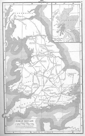
Map of Roman Britain
The Roman roads in Britain were constructed between approximately AD 50 and AD 400, in order to facilitate trade and military traffic between the different regions of Roman Britain (Britannia). There were no proper roads in Britannia prior to the arrival of the Romans. Instead, the native Brythons used trackways which were often located along hilltop ridges, such as the Ridgeway in southern England. Some of these trackways were later adapted by the Romans, but most of the road network was wholly new.
In southern Great Britain, Roman roads fell into disrepair in the Early Middle Ages, during which time they gained their present names. In some places, the origins of the roads were forgotten and they were ascribed to mythical Anglo-Saxon giants and divinities: for instance, Wade's Causeway in North Yorkshire owes its name to Woden, the supreme god of Germanic and Norse mythology.
The roads continued to be used for centuries thereafter. Chaucer's pilgrims in the Canterbury Tales almost certainly used Watling Street to travel from Southwark to Canterbury. However, the roads were mostly destroyed in the 18th and 19th century when toll roads were constructed on top of the Roman originals. Very few Roman roads have survived in anything like their original condition, and even then only for very short stretches - Wade's Causeway is widely regarded as the best-preserved in Britain. Many modern roads continue to use the old Roman alignments. Much of Watling Street, for example, is now under the A2 and A5.
The Roman engineers who constructed Britain’s first roads built them to a standard pattern replicated across the empire. Military roads tended to follow long, straight alignments between major towns and garrisons, while civil routes tended to follow the contours of the land in order to link farms and estates to their markets. The road was carried on an embankment (the agger), sometimes as much as 5 feet (1.5 m) high and 50 feet (15 m) wide, built up from soil excavated from drainage ditches on either side of the road. The road was surfaced with gravel wherever possible, but small broken stones or larger blocks or slabs were used if gravel was in short supply.
Many English place names derive from a position on or near a Roman road, usually denoted by the element -street (also strat-, strait-, streat- and other variants). Thus, for example, Stretham means “homestead or village on a Roman road” and likewise Stretford means “ford on a Roman road”.