

Course of the Royal Road
The course of the road has been reconstructed from the writings of Herodotus, archeological research, and other historical records. It began in the west in Sardis (about 60 miles east of Izmir in present-day Turkey), traveled east through what is now the middle northern section of Turkey to the old Assyrian capital Nineveh (present-day Mosul, Iraq), then traveled south to Babylon (present-day Baghdad, Iraq). From near Babylon, it is believed to have split into two routes, one traveling northwest then west through Ecbatana and on along the Silk Road, the other continuing east through the future Persian capital Susa (in present-day Iran) and then southeast to Persepolis.
History of the Royal Road
Because the road did not follow the shortest nor the easiest route between the important cities of the Persian Empire, archeologists believe the western-most sections of the road may have originally been built by the Assyrian kings, as the road plunges through the heart of their old empire. More eastern segments of the road (in present-day northern Iran) are coincident with the major trade route known as the Silk Road.
However, Darius I made the Royal Road as it is recognized today by improving the road bed and connecting the parts together in a unified whole, primarily as a quick mode of communication using the kingdom's messengers.
The construction of the road as improved by Darius was of such quality that the road continued to be used into Roman times. A bridge at Diyarbakir, Turkey still stands from this period of the road’s use.
Unit 7 Inca Road System
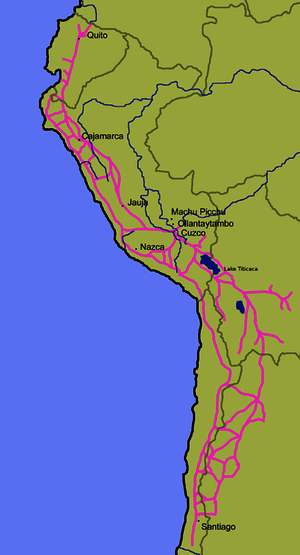
Among the many roads and trails constructed in pre-columbian South America, the Inca road system of Peru was the most extensive. Traversing the Andes Mountains and reaching heights of over 5,000 m (16,500 feet) above sea level, the trails connected the regions of the Inca Empire from the northern provincial capital in Quito (Ecuador) past the modern city of Santiago (Chile) in the south. The Inca road system covered approximately 22,500 km (14,000 mi) and provided access to over three million km² of territory.
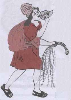
Major highways of the Inca Empire A chasqui playing a conch shell
Chaski
Since the Incas did not make use of the wheel for transportation, and did not have horses until the arrival of the Spanish in Peru in the 16th century, the trails were used almost exclusively by people walking, sometimes accompanied by pack animals, usually the llama.
The trails were used by the Inca people as a means of relaying messages, carried via knotted-cord quipu (A quipu usually consists of colored spun and plied thread from llama or alpaca hair or cotton cords with numeric and other values encoded by knots in a base 10 positional system. Quipus may have just a few strands, but some have up to 2,000 strands), books, and by memory; and for transporting goods. Messages could be carried by chasqui runners covering as much as 240 km (150 mi) per day.
Each chasqui carried a trumpet made of a conch shell or animal’s horn, a quipu in which information was stored, and a rucksack on his back to hold objects to be delivered. Chasquis worked using a relay system which allowed them to convey messages over very long distances within a short period of time.
There were approximately 2,000 inns placed at even intervals along the trails. The inns provided food, shelter and military supplies to the tens of thousands who traveled the roads. There were corrals for llamas and stored provisions such as corn, lima beans, dried potatoes, and llama jerky. Along the roads, local villagers would plant fruit trees that were watered by irrigation ditches. This enabled chasqui runners and other travelers to be refreshed while on their journeys. Inca rope bridges provided access across valleys.
Many of the trails converge on the center of the empire, the Inca capital city of Cusco. Therefore, it was easy for the Spanish conquistadors to locate the city. Traversing the trails on horseback proved to be difficult and treacherous for the Spanish in their attempts to conquer the Inca Empire.