

EG08_print
.pdfMagazine of the European Geography Association for students and young geographers
TheEuropean
Geographer
Water
8th issue
June 2012


 25
25
ISSN: 1605-6566

The European Geographer, 8th Issue
Colophon
The EGEA Magazine is a publication from the European Geography Association for Geography students and young Geographers.
The EGEA Magazine is published twice a year. The magazine is produced for the EGEA community, EGEA partners and all others interested in EGEA, geography and Europe.
Postal address:
EGEA
Faculty of Geosciences - Utrecht University P.O.Box 80.115
NL-3508 TC Utrecht Telephone: +31-30-2539708 E-mail: egea@egea.eu
E-mail EGEA magazine: egea.magazine@egea.eu Website: www.egea.eu
Editors of the eighth issue:
Inge Wiekenkamp (Chief Editor), Tobias Michl (Chief Editor), Ciprian Caraba, Colette Caruana, Cosmin Ceuca, Olga Chernopitskaya, Nicu Ciobotaru, Amanda Finger, Franziska Hübner, Annika Palomäki, Jakub Ondruch, Cristina Onet, Laura Helene Rasmussen, Julian Thesen
Graphic Design:
Cosmin Ceuca, Nicu Ciobotaru, Inge Wiekenkamp
Contributing authors:
Olga Chernopitskaya, Sergio Cuevas, Daria Golub, Franziska Häring, Aino Kirillova Ruben Maes, Tobias Michl, Sille Marie Myreng, Jakub Ondruch, Svetlana Samsonova, Sandra Teuber, Inge Wiekenkamp
Photos:
CENIA, Olga Chernopitskaya, Sergio Cuevas,
Google Earth, Stefan Esch, Aino Kirillova, Andreas
Christoffer Lundegaard, Ruben Maes, Tobias Michl,
Svetlana Samsonova, Sandra Teuber, J. Wenzel, Inge
Wiekenkamp
Coverphoto:
Daniel Metzke
All authors are completely responsible for the content of their articles and references made by them.
The editors would like to thank:
Sanne Heijt – EGEA BoE Secretariat Director 11/12 Faculty of Geosciences, Utrecht University
All authors
EGEA is supported by: ESRI
EUROGEO
Faculty of Geosciences, Utrecht University
Contents
3 Svetlana Samsonova
25 years of EGEA
4 Jakub Ondruch
Editorial: The European Geographer - 8th edition - Water
5 Franziska Häring and Tobias Michl
The role of water in urban development
8 Jakub Ondruch
Development of a cut-off meander in the lowland reaches of the Morava river after spring floods in 2006
11 Inge Wiekenkamp
How sustainable are water facilities in Bogotá? Water use and abuse in Bogotá-city, Colombia
17 Aino Kirillova
The role of water objects in the area of the Udmurt
Republic
19 Daria Golub
Virtual water trade
21 Olga Chernopitskaya
Water consumption in figures and ways to reduce it
23 Olga Chernopitskaya
Interesting facts about water
24 Ruben Maes
Drought, Dams, Development and Degradation: a 4D approach to sustainable water management in tropical highlands
28 Sille Marie Myreng
Notes from a newbie
29 Sergio Cuevas Pérez
The Sunny Weekend 2011
30 Sandra Teuber
The Western Regional Congress 2011
32 Svetlana Samsonova
The Altai Adventure: Unique culture and virgin nature
2

Water - June 2012
25 Years of EGEA
The year 2012 is a very mysterious |
For 25 years, we created a solid base for |
|
and special year. You could tell me |
future development. But many goals still lie |
|
many prophecies and beliefs about |
ahead. I sometimes dream that all European |
|
2012: the end of the world, the Earth’s |
Universities with a Geography department |
|
collision with a black hole, the Mayan |
will be represented in EGEA in the future. |
|
Calendar etc. For me this is all worth noth- |
EGEA needs more people involved in the |
|
ing because in 2012, we celebrate EGEA’s |
Association. We have to improve our hu- |
|
Silver birthday – and that is an occasion |
man recourses, to increase the number and |
|
of the highest importance for all of us! 25 |
quality of EGEA publications and events, to |
|
Years ago students from Utrecht, Warsaw |
get new funds for EGEA and to show EGEA |
|
and Barcelona organized a European net- |
to external world. The more professional |
|
work for geography students and young |
we get, the more prosperous EGEA is. |
|
geographers – EGEA. Now we are silver! |
EGEAns are young and enthusiastic stu- |
|
|
|
|
From the initial 3 founding entities, we |
dents who are ready to work and put efforts |
|
reached an amazing number of 87 enti- |
for their own future, to broaden their hori- |
|
ties, coming |
from 29 countries. EGEA |
zons and to experience the world. It is hard |
got the status of legal youth associa- |
to list all achievements that EGEA reached |
|
tion, its own website and budget; it has |
over the past 25 years. |
|
its own board and working committees. It |
|
|
is hard to count how many events on lo- |
However, one of the things that is worth |
|
cal, national and international level were |
most, is that we have a united communi- |
|
organized in the past 25 years – there |
ty, which we call our EGEA family. EGEA |
|
must have been thousands of events. In |
changes our lives. |
|
these 25 years, many EGEAns found new |
|
|
friends, participated in a number of EGEA |
Wherever in Europe you will go, you will |
|
activities, improved their scientific and |
always know that, because of EGEA, |
|
soft-skills and |
traveled across Europe. |
you can find friends, support and a good |
|
|
piece of advice. You will never be alone! |
Year by year we face new challenges, |
This is one of the big treasures of EGEA, |
|
overcome obstacles and exceed our |
that we should keep and pass to future |
|
expectations. |
|
generations. |
Always remember: “Individually, we are one waterdrop. Together, we are an ocean” (Ryunosuke Satoro). Thank you for believing in EGEA!
Yours
Svetlana Samsonova
EGEA President 2011/2012
Board of EGEA 2011-2012
3
The European Geographer, 8th Issue
Editorial - The European Geographer - 8th issue - Water
Jakub Ondruch,
EGEA Brno
Editor of the European
Geographer
Water, for chemical engineers it is just a molecule, a compound of hydrogen and oxygen, for our planet as a living organism an essential substance for its existence. Vast surfaces of water in our planet are such a significant feature that Earth even was given the name “the Blue Planet”.
The blue liquid is like a magician, who can conjure the presence of organisms up by life-giving rain as easily as take the life away by lethal floods. As a patient sculptor it shapes the surface into various landscapes and landforms. Many of them are admired by mankind thanks to their sophistication, perfection and inconceivability. Just imagine standing at the bank of the Colorado River in the Grand Canyon or at the margin of the Salto Ángel waterfall and try
to enquire yourself “How is that possible?” In the terrestrial wildlife many organisms have to struggle for a sufficient amount of water to survive. Animals do not hesitate to undergo a very long journey just to satisfy their throat.
Plants had to adjust their morphology, physiology to be able to face the lack of the vital liquid. Besides that, water belongs to one of the most important factors determining the diversity and presence of a particular species in general.
One species markedly differs from the rest - human. Through its evolution many ways of water use have been developed. We learnt how to employ water as our helper, how to utilize its power and how to suppress our dependency on the water distribution. We have created business with this fluid. Our society reached a certain stage of development in which new important water issues have arisen, e.g. availability, contamination.
For us, geographers, the theme of water offers numbers of possibili-
ties to be concerned with. It opens the door to pure environmental themed articles as well as to socio-economical ones. EGEA involves various people from every corner of Europe, who have different experience, opinions, ideas, interests obtained thanks to the dissimilar conditions predominating in a particular region.
The contribution of such a diverse group of authors, writing articles from many different points of view, helps us to form our own opinion based on more information, which could be considerably divergent in comparison to those relevant in our home country.
I entered the |
running train recently |
when I joined |
the editorial board and |
have already had the opportunity to observe the whole process of creating the magazine. The results you are holding in hands.
All editors have done a great job and deserve appreciation. But any editor is useless without articles, and thus my thanks belongs also to all authors who sacrificed time to share their experience with us.
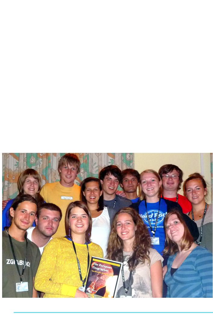
Figure : Editorial Board of the European Geographer at the Annual Congress 2011 in Ebermannstadt (Germany)
4
Water - June 2012
The role of water in urban development
The example of the historical and current development of Augsburg, Germany
Franziska Häring,
Tobias Michl
EGEA Augsburg
Augsburg University
Introduction
Water is one of the most important factors for the founding and the development of a city because it is essential in many aspects of urban life. Many bigger as well as smaller cities in Europe and all over the world are located near water: London is situated on the riverbanks of the Thames, the Danube flows through Vienna, Stockholm is located between Lake Mälaren and the Baltic Sea, Istanbul lies at the shores of the Black Sea and the Bosporus. Why is water so important for urban development?
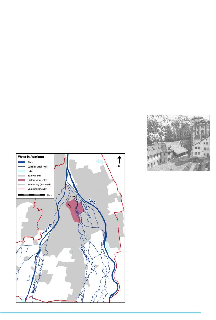
In this article we want to show some aspects of how water has influenced and will maybe further influence the development of the city ofAugsburg (see figure 1).
Historical development of Augsburg
Augsburg, the third largest city of the German federal state Bavaria, is situated in the northern part of the Alpine foreland, about 80 km north of the Alps. The landscape is characterized by fluvial terraces, which are the results of fluvioglacial processes during the Pleistocene. Two of the rivers that were part of the drainage system in the last ice age are the Lech and the Wertach, both nowadays rising in the Alps and flowing together in the north of Augsburg. The space between the two river valleys has not been affected by erosion.
Therefore older gravel sediments are preserved and they now builds up a ridge overlooking the surroundings. This makes the location a strategically favourable position. Due to traditional trade routes passing through this locality, it is also supposed to have attracted settlers throughout all times whereas the oldest artefacts only date from the early Bronze Age (Bakker, 1985b). When the Romans conquered the Alpine foreland around 15 B.C., a castrum was established in the
Wertach valley but was abandoned in 17 A.D. Instead, the urban settlement Augusta Vindelicum was founded on the previously mentioned ridge. The Municipum Aelium Augustum was the capital of the Roman province Raethia from the 1st or 2nd until the 5th century A.D. A settlement like this needs water supply, which was ensured by two independent systems.
The drinking water was delivered from several wells. Service water, e.g. for baths, toilets and production purposes, came to the city via a 35 km long canal which originates from the little river Singold, which transported 86 million litres per day for about 300 years (Augsburger Allgemeine 2011).
Figure 2: “Brunnenmeisterhaus” (house of the foreman of the water works) and water towers near the “Rotes Tor” town gate, both part of the historical water works Source: Pfister, F., 1989
Figure 1: Water in Augsburg
As there are no clear historical testimonies on the decades that followed, there also is a lack of information on water management of that time. The beginning of the technically advanced water supply can be dated back to 1412, when the first water works were built in the southeast of the city. The difficulty was to lift up the water from the river valley to the higher fluvial terrace, which was solved by using Archimedean screws and building water towers (see figure 2).
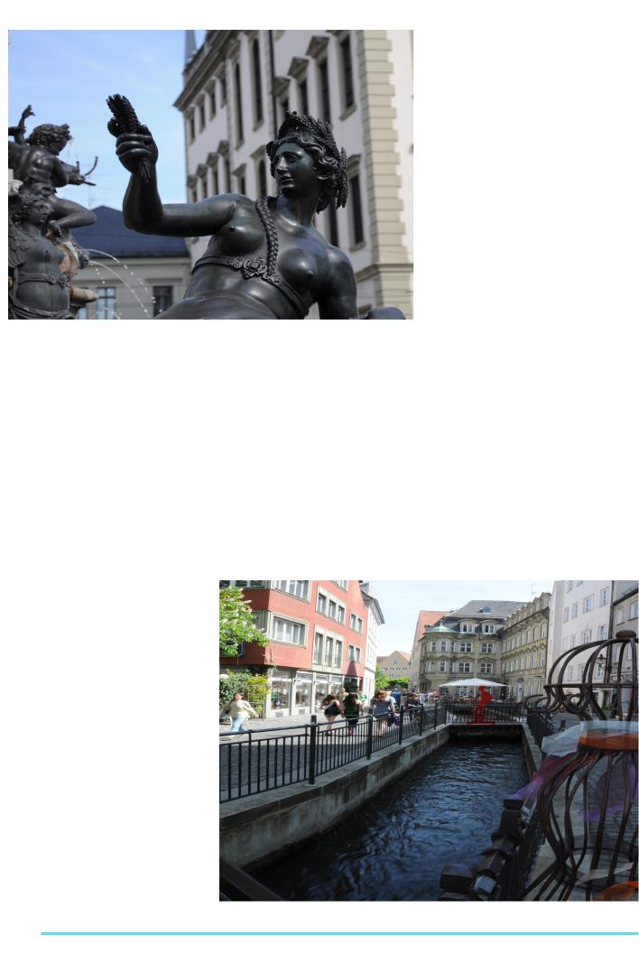
In the following one hundred years some other water works were built which altogether ensured the water supply of the city for several centuries (Stadtwerke Augsburg 1979). Augsburg was a very wealthy city in those days. To show this, three fountains were built between 1588 and 1602 with statues by the famous Dutch sculptor Adriaen de Vries. The Augustus-fountain (see figure 3) on the town hall square shows the importance of the rivers around the city: Lech, Wertach, Singold and Brunnenbach (which was used for centuries
5
The European Geographer, 8th Issue |
|
|
|
|
|
|||
|
|
|
be compared with the history of Geogra- |
|||||
|
|
|
phy, where nature was first seen as the |
|||||
|
|
|
determining factor for mankind and was |
|||||
|
|
|
later replaced by a possibilistic attitude that |
|||||
|
|
|
assumed all natural resources as being |
|||||
|
|
|
adaptable to any human needs or wishes. |
|||||
|
|
|
The importance of water in a city of the |
|||||
|
|
|
|
21st century |
|
|
||
|
|
|
The |
previously |
mentioned |
canals |
from |
|
|
|
|
the Lech were concealed with concrete |
|||||
|
|
|
panels between the 1930s and the 1950s to |
|||||
|
|
|
create more road space in the narrow streets |
|||||
|
|
|
of the historical city centre. Due to the |
|||||
|
|
|
decay in this district and for the 2000-year- |
|||||
|
|
|
anniversary of Augsburg in 1985, a compre- |
|||||
|
|
|
hensive revitalization and redevelopment |
|||||
|
|
|
programme was initiated by the municipal |
|||||
|
|
|
authorities in the middle of the 1970s. An |
|||||
|
|
|
important aspect was to uncover the canals |
|||||
|
|
|
to make water a part of the city again (see |
|||||
Figure 3: Statue of the Wertach, Augustus fountain |
figure |
4), re-establish its historical |
impor- |
|||||
tance and put it in a modern context (Sajons |
||||||||
|
|
|
||||||
for the water supply). The rivers are rep- |
Augsburg and Bavaria in 1596 when |
1989). “Especially on hot summer days, the |
||||||
resented by four fountain figures that |
the Bavarians built a dam to cut off the |
abidance near these creeks makes people |
||||||
are grouped around the Roman em- |
water supply of Augsburg (Kluger 2011). |
feel comfortable as they reduce the heat in |
||||||
peror Augustus, the founder of the city. |
Bigger change did not occur until the |
the narrow streets” (Sajons 1989, p. 108). |
||||||
|
|
beginning of the 19th century when |
This example shows one of the main |
|||||
Water was not only important for house- |
Augsburg was made a province of their |
|||||||
holds but also for the economy. Many |
‘enemy’ Bavaria after the Napoleonic |
functions of water in today’s |
cities: |
|||||
canals were built since the 11th centu- |
Wars and authorities began to regulate |
Water can be essential in providing a good |
||||||
ry from the river Lech to the inner city, |
the river using hydraulic-engineering tech- |
quality of living and also health-related |
||||||
where craftspeople used it as a power |
nology (Stadt Augsburg et al 1991). From |
quality of life. The Lech canals have lost |
||||||
source, to process water and for waste |
the beginning of the 20th century, the |
their direct economical importance, but the |
||||||
disposal. This direct access to water |
river could be used to generate electricity. |
attractiveness of the city is increased both for |
||||||
was the source of the wealth of the |
|
local population and tourists who increase |
||||||
city. These canals still exist today and |
History shows the change of the role |
sales |
of shops, |
restaurants |
and |
cafés. |
||
preserve the remaining structures of |
of water in urban development from a |
Water is not only important in the city |
||||||
the medieval craftsmen district (Schaf- |
formerly determining factor to a resource |
|||||||
fer 1989). Many of the small streets in |
that is modified and intentionally used |
centre but can have the same effects on |
||||||
the historical city centre have names |
according to people’s needs. This can |
the living quality |
in surrounding quarters |
|||||
related to either the canals, e.g. “Vor- |
|
|
|
|
|
|
||
derer Lech”, “Am Brunnenlech” or the |
|
|
|
|
|
|
||
professions of the craftspeople who |
|
|
|
|
|
|
||
were working there, e.g. “Schlosser- |
|
|
|
|
|
|
||
mauer” (metal worker), “Schmiedgasse” |
|
|
|
|
|
|
||
(blacksmith), “Bäckergasse” |
(baker). |
|
|
|
|
|
|
|
The Lech, which is the biggest river of |
|
|
|
|
|
|
||
the three, also has played an important |
|
|
|
|
|
|
||
role for the development of Augsburg |
|
|
|
|
|
|
||
from the Middle Ages until today. It has |
|
|
|
|
|
|
||
been a cultural and language border, de- |
|
|
|
|
|
|
||
termining the development both on the |
|
|
|
|
|
|
||
east and on the west side. Augsburg has |
|
|
|
|
|
|
||
been under the influence of the Swabian |
|
|
|
|
|
|
||
Alemanni for most of the time, whereas |
|
|
|
|
|
|
||
the land east of the river was ruled by the |
|
|
|
|
|
|
||
Bavarian Baiuvarii (Oblinger 2001). The |
|
|
|
|
|
|
||
meandering river relocated its riverbed, |
|
|
|
|
|
|
||
which meant that also the border moved. |
|
|
|
|
|
|
||
To use this to their own advantage, both |
|
|
|
|
|
|
||
sides tried to push the river to the op- |
|
|
|
|
|
|
||
ponents’ side to gain more land, which |
|
|
|
|
|
|
||
is shown by several trials that were held |
|
|
|
|
|
|
||
on these issues (Oblinger 2001). Even |
|
|
|
|
|
|
||
a “war on water” broke out |
between |
Figure 4: Lech canal in the historical city centre |
|
|
|
|||
6
|
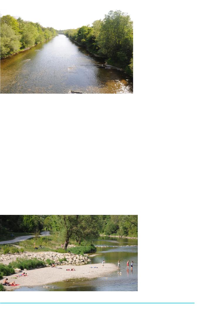
Figure 5: View on the Wertach before the project “Wertach vital” |
|||
and suburbs. We will show this with the |
for flood protection and creating flood- |
|||
example of the Wertach, where some |
plains. Therefore, the riverbanks have been |
|||
major changes occurred in the past ten |
widened, which eases the access to the river. |
|||
years. The river was straightened since |
|
|||
the 1860s to gain new farmland and to |
The more natural environment makes the |
|||
improve flood protection by an increased |
area more attractive to people. This is |
|||
discharge |
(Uffinger |
2011, see |
figure 5). shown by an increasing number of people |
|
|
|
|
|
who use the riverbanks for promenading, |
This second aspect was not too success- |
cycling, relaxing, sunbathing, barbecuing |
|||
ful as shown by two floods that occurred |
and as a playground for children (see figure |
|||
in 1965 and 1999, which both caused big |
6). The flood prevention works quite well |
|||
damage |
in the |
surrounding |
quarters. |
as a high water in August 2005 resulted |
After the Whitsun flood of 1999 the |
in no damage. However, the Wertach re- |
|||
authorities put more effort in the project |
mains a not completely controllable natural |
|||
“Wertach vital”, of which the planning pro- |
force, which is something that has to be |
|||
cess had already started before this event. taken into account for further development.
The goals of this project are flood preven- |
Conclusion |
||
tion, reduction of erosion at the riverbed, |
|||
renaturation of the ecosystem and creation |
|
||
of a local recreation area in the city (Was- |
The role of water as a locational factor in |
||
serwirtschaftsamt Donauwörth |
& |
Stadt |
urban development has changed over |
Augsburg 2007). The project is realized |
time from a determining criterion to an as- |
||
by the Free State of Bavaria and support- |
pect that provides risk as well as potential, |
||
ed by the municipality of Augsburg as well |
which both are not completely manage- |
||
as the European Union. The measures |
able. Nevertheless, water still plays a very |
||
taken are: building ramps to slow down |
important role concerning the quality of life, |
||
the flow velocity, constructing |
new |
dams |
aesthetics and some economic sectors. |
Water - June 2012
References
Augsburger Allgemeine 2011. Der Durst nach Wasser. In Augsburger Allgemeine 23.04.2011. Augsburg.
Bakker, L. 1985a. Die Anfänge der Zivilsiedlung Augusta Vindelicum. In Geschichte der
Stadt Augsburg von der Römerzeit bis zur Gegenwart, 2nd edition, ed. Gottlieb, G. Baer, W. Becker, J. Bellot, J. Filser, K. Fried, P. Reinhard, W. Schimmelpfennig, B., 3441. Stuttgart: Konrad Theiss Verlag.
Bakker, L. 1985b. Zur Topographie der Provinzhauptstadt Augusta Vindelicum. In
Geschichte der Stadt Augsburg von der Römerzeit bis zur Gegenwart, 2nd edition, ed. Gottlieb, G. Baer, W. Becker, J. Bellot, J. Filser, K. Fried, P. Reinhard, W. Schimmelpfennig, B., 4150. Stuttgart: Konrad Theiss
Verlag.
Uffinger, B. 2011. Wertach vital – Auszüge aus einem Bericht des Wasserwirtschaftamt Donauwörth. Available from: http://www.bnaugsburg.de/content.php?id=120 (Accessed 30 May 2011)
Kluger, M. ed. Lechwerke AG 2011. Der Lech.
Augsburg: context verlag.
Oblinger, H. 2001. Das Nördliche Lechtal in Vergangenheit und Gegenwart. In Der nördliche Lech, ed. Naturwissenschaftlicher Verein für Schwaben e.V.. Augsburg: Wißner-Verlag. pp. 11-44.
Pfister, F. 1989. Ansichten der Wohnumgebung in der Altstadt. In Altstadtsanierung in
Augsburg, ed. Schaffer, F. Thieme, K.. Augsburg: Lehrstuhl für Sozialund Wirtschaftsgeographie. pp. 121-130.
Sajons, R. 1989. Praxis der Altstadtsanierung in Augsburg. In Altstadtsanierung in Augsburg, ed. Schaffer, F. Thieme, K.. Augsburg: Lehrstuhl für Sozialund Wirtschaftsgeographie. pp. 109-113.
Schaffer, F. 1989. Praxisbegleitende Untersuchungen zur Altstadtsanierung in Augsburg. In Altstadtsanierung in Augsburg, ed. Schaffer, F. Thieme, K., Augsburg: Lehrstuhl für Sozialund Wirtschaftsgeographie. pp. 131.146.
Stadt Augsburg, Referat Umwelt und Kommunales, Amt für Grünordnung und Naturschutz 1991. Augsburger ökologische Schriften 2, Der Lech, Wandel einer Wildflußlandschaft. Augsburg.
ed. |
Stadtwerke |
Augsburg |
1979. |
Wasser |
für |
Augsburg. |
Augsburg. |
Wasserwirtschaftsamt Donauwörth, Stadt Augsburg 2007. Wertach vital… …natürlich für Augsburg. Donauwörth.
Figure 6 : Results of the renaturation of the Wertach with widened riverbanks and the possibility for local recreation
7
The European Geographer, 8th Issue
Development of a cut-off meander in the lowland reach of the Morava river after spring floods in 2006
Jakub Ondruch,
Masarykova Univerzita, Brno
EGEA Brno
Introduction
(Constantine et al., 2010). On the other hand, cut-off channels with a small diversion angle are supplied with a large amount of both fine-grained and coarsegrainedmaterial,leadingtofastaggradation inside a whole reach (Dunne et al., 2010).
Methods
Meandering belongs to the basic mecha- |
In situ measurements were conducted |
|||
nism of large rivers as well as tiny streams |
||||
evolution |
which forms |
characteristic |
from August, 2010 to March, 2011 when |
|
landscapes. By virtue of lateral erosion |
data about river bed, plugs, banks mor- |
|||
and overbank sedimentation over the |
phology and vegetation cover of newly |
|||
sufficient time period floodplain is |
formed surface was acquired (Fig. 1). |
|||
developed. |
Unconsolidated |
floodplain |
Relative elevations of alluvial plugs were |
|
sediment is favourable for subsequent |
obtained applying a level instrument. |
|||
lateral erosion, supporting meander de- |
|
|||
velopment. Occasionally, |
two |
meanders |
|
|
are drawn to each other narrowing their neck, which could lead to a breakthrough and an abandoned meander genesis.
Cut-off meanders have a positive effect on water quality, flood mitigation, and represent a valuable habitat increasing flood- plainbiodiversity(Gliňska-Lewczuk,2009).
In the Czech Republic, there are only two significant reaches of larger lowland rivers that form meander belts. One of them is located in the Natural Park
Strážnické Pomoraví where the Morava river has undergone substantial development since spring flood in 2006, when the neck cut-off occurred. Neck cut-off is a process of river narrowing where the meander neck width is smaller than the water course width (Gay et al., 1998). Such a type of cut-off is more common on rivers with a low gradient (Hooke, 1995).
Fundamental mechanism of cut-off meanders
lizing a clinometer and of water depth by employing fishing sonar. Afterwards, they were investigated in the inflection points, bends and meander apex.
Data was |
compared with |
similar of |
||
two |
reference meanders |
in order |
||
to |
roughly |
determine |
the |
thickness |
of |
the sediment layer |
accumulated |
||
in abandoned channel after cut-off. Comparison of the slopes of active and abandoned concave banks was enabled by collecting data from 21 segments of both concaves which were subsequently divided into five parts. For each part of the segment the average slope was estimated.
Sedimentation processes inside cut-off meanders are in general conditioned by three groups of factors: (1) the concentration of overbank sediments, (2) the hydraulic connectivity with an active channel, and (3) the sediment restrain ability, given by geometrical characteristics of cut-off channels (Cittero & Piégay, 2009).
The diversion angle (i.e. angle between the active and abandoned channel) belongs to the most important variables affecting the dynamics and the character of sedimentation processes.
In abandoned channels, carved under high angle, alluvial plugs are developed within a short time, leading to an isolation of an oxbow lake and a decrease of coarse-grained material supply
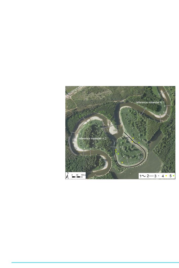
Figure 1: Field measurement settings in the reach of the Morava river in the Stážnické Pomoraví. 1-Longitudinal profile, 2-Cross-sections, 3-Points of concave bank morphology measurements,
4-Sites of vegetation age measurements, 5-Sites of brest-height diameter measurements Ortofoto: CENIA, 2009
The morphology of the river bed was investigated with a measuring rod from an inflatable boat. Every spot of depth determination was recorded with a touristic GPS device with an accuracy of first orders of meters. Because of the latter, imperfection flaws have been made. The use of a precise GPS apparatus with an accuracy of tens of millimetres was tested but due to various impediments, such as a rapid increase of inaccuracy inside homogeneous willow cover or impassable ice layer covering significant part of residual lake when measurement was conducted, obtained data could not be used.
Cross section profiles were constructed from measurements of bank slopes by uti-
Stand density, breast-height diameter and age of vegetation cover was measured in squares sized 5x5 m in order to determinate the beginning of plant succession. Number of cut down trees and their spatial distribution was counted and observed.
Results
Spring flood, which caused the breakthrough, ran over the Natural Park
Strážnické Pomoraví from 27th of March to 10th of April 2006. Within the first three months after incision an upstream alluvial plug was formed obstructing material inflow (Fig. 2). Material transport into the meander proceeded mainly through
8
Water - June 2012
a downstream arm. Diverted water flow entering the downstream part of the meander lowered the ability to sediment transport as penetrated into the abandoned channel resulting downstream sedimentation of material and point bar aggradation.
Two months later, another alluvial plug was developed and rapid morphological changes stopped. Since then, sedimentation rate in the cut-off meander has slowed down significantly and taken place only at higher water levels.
As mentioned above, diversion angle affects sedimentation processes inside the cut-off meander. The meander of the Morava river has a diversion angle of 24°. Despite the small angle both alluvial plugs are developed and the abandoned channel has undergone similar evolution to meander with a high diversion angle.
This has been researched by other authors (e.g. Constantine et. al, 2010), who suggested that more variables and regional dissimilarities have to be taken into account when studying cut-off meander evolution. Neck incision changes the river flow pattern resulting into alteration of erosion-accumulation processes in the active channel (Fig. 3). In a place, where lateral erosion had predominated before cutoff point bar has been formed afterwards.
The opposite has taken place |
at the |
left bank where erosion has |
started. |
The length of the reach was shortened by approximately 800 m. Shortening such a significant part of the river course has impact on decrease of sinuosity, defined as a ratio between real stream distance and straight distance of two inflexion points (Micheli & Larsen, 2010),
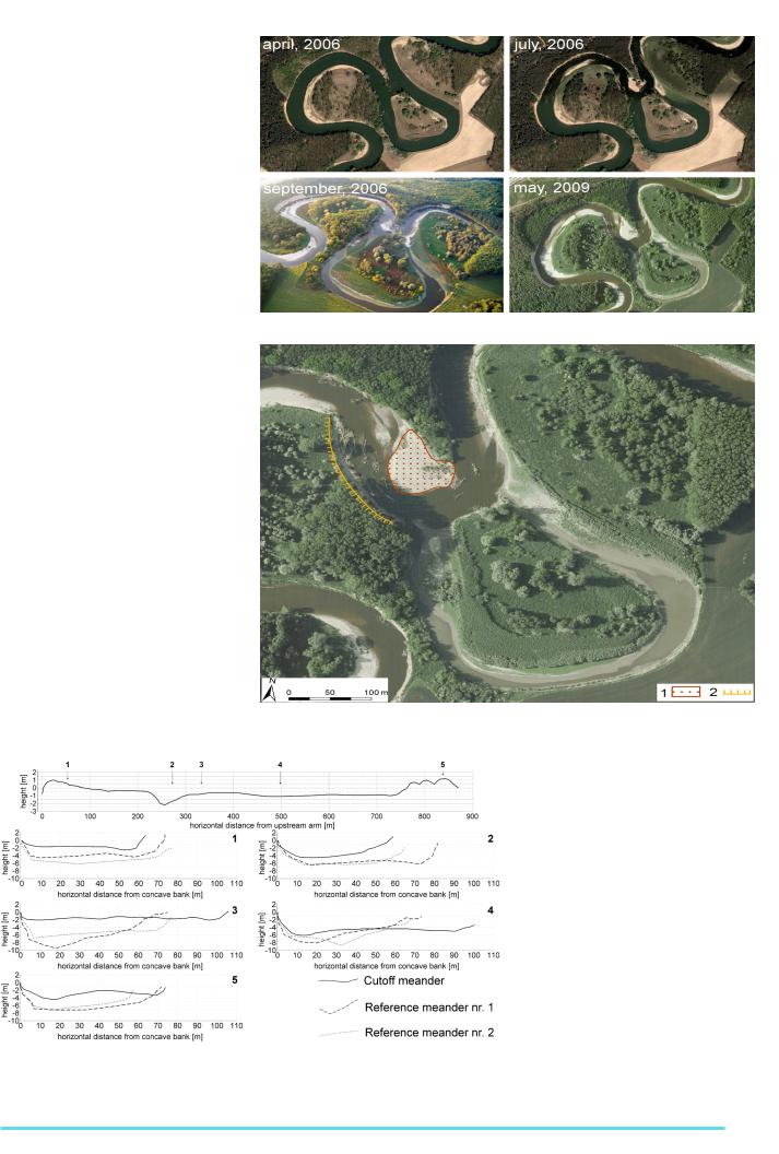
Figure 2: Abandoned channel development since cut-off in lowland reach of Morava river. Source: Google Earth 2006, 2009 and Wenzel, J. 2006.
Figure 3: Erosion-accumulation processes alteration in the active channel of Morava river after cutoff. 1-Newly induced accumulation, 2-Newly induced erosion
Ortofoto: CENIA, 2009.
Fig. 4: Longitudinal and cross-section profiles of the cut-off meander and two reference meanders. (Longitudinal profile: An elevation of 0 m corresponds with a water level in a height of 240 m.)
and increase of gradient at local level. The longitudinal profile (Fig. 4) delineates clearly alluvial plugs. State, when plugs are able to prevent material input at regular water levels, is developed within a period of few months up to ten years (Gagliano & Howard, 1984; Hooke, 1995). Thickness of the sedimented layer of alluvial plugs is estimated to 3 m – 4.7 m. Behind the upstream alluvial plug the deepest pool inside the abandoned channel is found. Cross-section in the same spot suggests thickness of sediments accumulated after spring 2006 from 0.75 m – 2 m but, in fact, a lower value would be more probable. The comparison with reference meander no. 2, which has the same geometry (i.e. straight section in the meander apex leads to the assumption that the pool situated in downstream bend has been originally deeper. The considerable change is
9

The European Geographer, 8th Issue
Fig. 5: Frequency histogram of slopes of concave banks in active (A) and cut-off (B) meanders in Morava river.
apparent in the apex of the meander, where |
cover which vegetates on the most sub- |
||||||||||||||||
point bar has grown substantially. It has |
stantial part of newly originated areas. |
||||||||||||||||
already reached an opposite bank and its |
Stand |
density |
varies |
between |
25 |
||||||||||||
thickness is comparable to alluvial plugs. |
pieces |
per 25 |
m2 |
on |
the |
highest |
|||||||||||
|
|
|
|
|
|
|
|
|
part of downstream alluvial plug to |
||||||||
Research on concave banks was |
approximately |
65 |
pieces |
per |
25 |
m2 |
|||||||||||
conducted in order to find out whether the |
on upstream |
alluvial |
plug |
and |
point |
||||||||||||
slopes of cut-off meander differ from those |
bar. Median of breast-height diameter |
||||||||||||||||
of active channel. Mills & Mills (2001) |
reaches 10 mm – 15 mm in more dense |
||||||||||||||||
determined significant lower slope angles |
cover and 25 mm in less dense stand. |
||||||||||||||||
of cut-off meanders even within a short |
|
|
Conclusion |
|
|
|
|
||||||||||
time after incision. Statistic testing was |
|
|
|
|
|
|
|||||||||||
employed in order to determine signifi- |
The abandoned meander has undergone |
||||||||||||||||
cant difference of slopes in Morava river |
|||||||||||||||||
meanders. Results approve latter state- |
significant development since spring flood |
||||||||||||||||
ments. Almost 70 % of slopes of the con- |
in 2006 when neck cut-off occurred. The |
||||||||||||||||
cave bank in the abandoned channel vary |
most rapid changes happened in the |
||||||||||||||||
between 20° and 40°, subvertical faces are |
same year as abandonment. Develop- |
||||||||||||||||
negligible, and overhanging surface is not |
ment under low diversion angle has not |
||||||||||||||||
present (Fig. 5, A). In contrast, slopes of |
corresponded to general rules stated in |
||||||||||||||||
active channel concave are more diverse, |
literature, suggesting |
regional |
specifics |
||||||||||||||
subvertical faces form substantial part |
must be taken into account. Processes |
||||||||||||||||
(approximately 15 %) and overhanging |
of oxbow lakes and abandoned channels |
||||||||||||||||
surfaces are present with 6 % (Fig. 5, B). |
development are very rare phenomena |
||||||||||||||||
|
|
|
|
|
|
|
|
|
studied in Czech Republic and optimal |
||||||||
Patterns |
of |
vegetative |
succession |
methods for the comprehensive assess- |
|||||||||||||
have |
not been |
studied |
in |
Natural |
ment remain to be developed. For latter |
||||||||||||
Park |
Strážnické |
Pomoraví, |
and |
thus |
reasons, topics, concerned with cut-off |
||||||||||||
we can only reckon with respect to |
meanders, are challenging and vital for |
||||||||||||||||
another study taken place in far upstream |
understanding |
of |
floodplain |
dynamics. |
|||||||||||||
reach of Morava river. Newly formed |
|
Acknowledgments |
|
|
|
||||||||||||
surfaces are initially colonised by |
|
|
|
|
|||||||||||||
invasive |
hydrophytic |
or |
hydrotoler- |
I would like to thank Mgr. Zdeněk |
|||||||||||||
ant |
species |
(e.g. |
Solidago |
gigan- |
|||||||||||||
tea, |
Impatiens |
glandulifera, |
|
Salix |
Máčka, Ph.D. for his time spent on |
||||||||||||
triandra,Alnusglutinosa)(Kovářetal.,2002). |
helping while field research was |
||||||||||||||||
Dendrometric |
measurements |
|
were |
conducted as well as for advices and |
|||||||||||||
employed in order to determine the |
critique. Additionally, I would like to |
||||||||||||||||
beginning of the vegetative succession |
mention valuable advices and help in field |
||||||||||||||||
of newly formed areas. The age of the |
provided by Mgr. Monika Michálková, Ph.D, |
||||||||||||||||
oldest trees was up to four and half years |
Ing.AndrejŠkrinárandMgr.LibušeVodová. |
||||||||||||||||
signifying |
that |
|
vegetative |
coloniza- |
|
|
|
|
|
|
|
|
|
||||
tion started in the same year as cut-off |
|
|
|
|
|
|
|
|
|
||||||||
occurred. |
Woody |
plants leading |
the |
|
|
|
|
|
|
|
|
|
|||||
succession are willows (Salix). Since |
|
|
|
|
|
|
|
|
|
||||||||
2007 poplar´s (Populus) cover on the |
|
|
|
|
|
|
|
|
|
||||||||
upstream alluvial plug has grown. |
|
|
|
|
|
|
|
|
|
||||||||
Willows |
form |
a |
dense |
homogenic |
|
|
|
|
|
|
|
|
|
||||
References
Cittero, A. and Piégay, H., 2009. Overbank sedimentation rates in former channel lakes: characterization and control factors. Sedimentology., 56, 2, p. 461-482.
Constantine, J. A., Dunne, T., Piégay, H. and Mathias Kondolf, G., 2010. Controls on the alluviation of oxbow lakes by bedmaterial load along the Sacramento River,
California. |
Sedimentology. |
57, |
2, |
pp. 389–407. |
|
|
|
Dunne, T., Constantine, J.A, Singer, M.B., 2010. The role of sediment transport and sediment supply in the evolution of river channel and floodplain complexity. Transactions, Japanese Geomorphological Union. 2010, 31, 2, pp. 155-170.
Gagliano, S.M., Howard, P.C., 1984. The neck cutoff oxbow lake cycle along the Lower Mississippi River. River Meandering, pp. 147-158.
Gay. G.R., Gay, H.H., Gay, W.H., Martinson, H.A., Meade, R.H., Moody, J.A., 1998. Evolution of cutoffs across meander necks in Powder River, Montana, USA. Earth Surface Processes and Landforms. 23, 7, pp. 651-662.
Glinska-Lewczuk, |
K., 2009. Water qual- |
||||
ity dynamics |
of |
oxbow lakes |
in |
young |
|
glacial |
landscape |
of NE Poland in re- |
|||
lation |
to their |
hydrological |
connectiv- |
||
ity. Ecological |
Engineering. 35, 1, |
pp. |
25-37. |
||
Hooke, J. M., 1995. River channel adjustment to meander cutoffs on the River
Bollin and River Dane, northwest England. Geomorphology. 14, 3, pp. 235-253.
Kovář, P., Janoušková, P., Koppová, J., Köppl,
P.,Křivánek,M.,2002.Vegetačnísukcesevnivě
řekypětletpozáplavě.Ţiva.88,6,pp.253–257.
Micheli, |
E. R.., |
Larsen, E. W., |
2010. |
River |
channel |
cutoff dynamics, |
Sacra- |
mento River, California, USA. River Research and Application. 27, 3, pp. 328-344.
Mills, H.H., Mills, R.T., 2001. Evolution of undercut slopes on abandoned incised meanders in the Eastern Highland Rim of Tennessee, USA. Geomorphology. 38, 3-4, pp. 317-336.
10