

EG08_print
.pdfWater - June 2012
perts came to our accommodation De Zonnewende. In a training session about visualisation we had to depict the word “human” with different materials (figure 2). This was a fun experience and since there were 6 groups, we managed to write the theme of this year’s WRC in our own lettering.
In the second training session I attended, an actress showed us how to present us in the best possible way. After singing a short song to take away our shyness and after finding out how to be of high or low status, the role play began.
For one hour we became chiefs and employees, we were shy and nervous and then confident and proud. We walked tall and low and had a lot to laugh about. In the other training sessions people did yoga to cope with stress, had to conceptualise their future or did other interesting things.
In the afternoon we had a drum session (figure 3) in the forest where we made a lot of noise, followed by the “EGEA’s got talent show” which proved that EGEA indeed has got some talent. The day ended with the Dutch night where there was a lot of orange!
Figure 3: Drum session, Source: Esch, 2011
After another short night, the workshop excursions took place. My workshop went to Deltares, an independent research institute which develops solutions for water and flood management. We also visited Dordrecht where you can take a flood management walking tour (figure 4).
The evening started with the final workshop discussion and ended with the traditional BDC and a last party with all the new people we had met.
The congress was a success and besides all the fun every participant had the chance to learn new things and leave with a lot of new impressions.
Figure 4: Dordrecht, Source: Teuber, 2011
31
The European Geographer, 8th Issue
The Altai Adventure: Unique culture and virgin nature
Altai Mountains, Siberia (Russia) 16th July – 7th August 2010
Svetlana Samsonova,
EGEA Moscow
Introduction
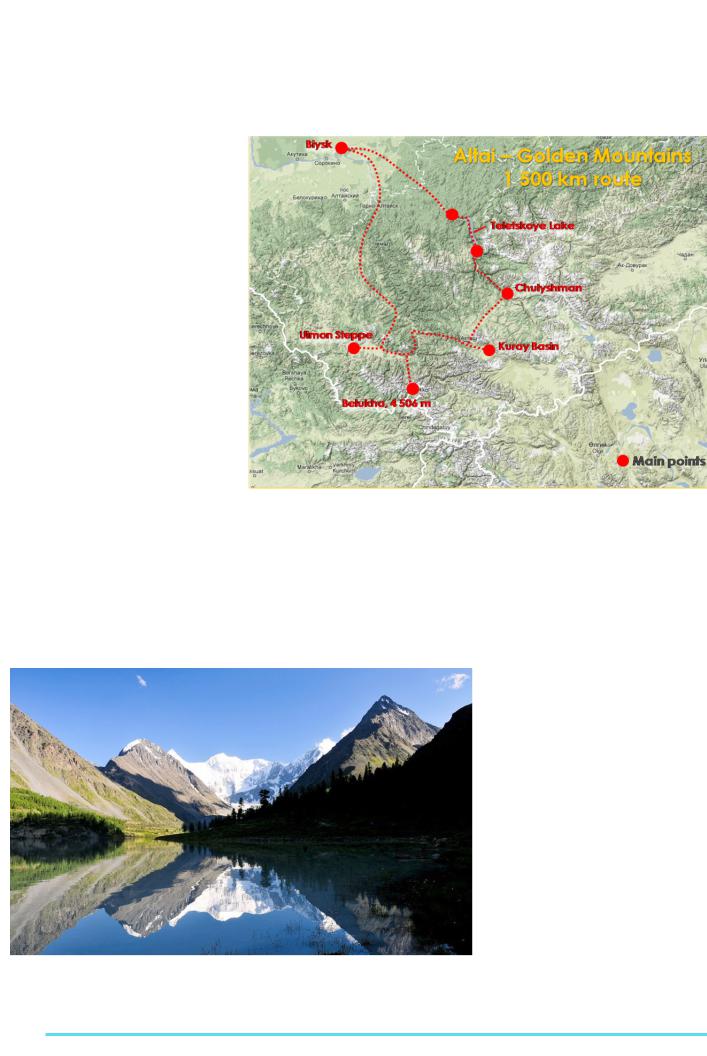
From 16th July to 7th August 2010 EGEA Moscow and EGEA Izhevsk organized the Altai Adventure, a 3 weeks hiking tour in the wild region of Siberia. On the expedition, 19 participants from 9 countries took part. We passed around 200 km by foot in 23 days at different altitude levels (4002700 m), in different landscape zones.
About the Altai Mountains |
|
|
|
The Altai Mountains are a mountain range |
|
|
|
in the Central Asia and are located where |
|
|
|
Russia, China, Mongolia and Kazakhstan |
|
|
|
come together. Here is the original locus |
|
|
|
of the speakers of the Turkic language |
|
|
|
and other members of the Altaic language |
|
|
|
group. The Altai Mountains are described |
|
|
|
as “Golden Mountains” (“Altai” means |
|
|
|
“gold” in Turkic) (Wikipedia, 2010. Altai |
Figure 1: Altai expedition route |
||
Mountains). |
|||
area we can distinguish steppe, forest- |
1) At the plain territory (Altai Krai): steppe, |
||
|
|||
The Altai Mountains are located at a junc- |
steppe, forest, high mountains and nival |
forest-steppe and forest landscapes; |
|
tion of a few biogeographical provinces. |
zones. |
2) At the Low mountain region (Altai Re- |
|
The contrasting habitats (because of the |
|
public): forest-steppe and forest land- |
|
contrast in relief) explain its high biologi- |
During our expedition we crossed the Al- |
scapes; |
|
cal and landscape diversity. The Altai flora |
tai region from the north to the south (see |
3) At the High mountain region (Altai Re- |
|
comprises 1840 species, of which 11 % are |
figure 1) and had a unique chance to ob- |
public): forest landscapes, tundra, alpine |
|
endemic (Maria Shahgedanova, 2003). |
serve a great variety of landscapes with a |
and subalpine meadows (see figure 2). |
|
Vertical zonation is clearly exhibited in the |
characteristical environment: |
The Objectives of the Altai Adventure |
|
distribution of the Altai vegetation: In this |
|
||
|
|
For the Altai Adventure organizing team, |
|
|
|
there were several reasons to organize |
|
|
|
the Altai Adventure: |
|
|
|
- To promote the distant Altai region |
|
|
|
The Altai Mountains are situated in the |
|
|
|
middle of Eurasia, in the developing re- |
|
|
|
gion of Russia. The example of the Altai |
|
|
|
Mountains is a good chance to show the |
|
|
|
diversity and beauty of virgin mountain |
|
|
|
area and to focus on the Altai Mountains |
|
|
|
as an analogue of Alps before settlement. |
|
|
|
- To show the possibility of the coexistence |
|
|
|
of an unique ancient culture and virgin na- |
|
|
|
ture and to explain how people can take |
|
|
|
natural features into account when adapt- |
|
|
|
ing their life to it. |
|
Figure 2: Belukha Mountain – Source: Andreas Christoffer Lundegaard (EGEA Copenhagen) |
The Altai region has a great history - peo- |
||
Located in the Katun Mountains, it is the highest peak of the Altai in Russia. It is part of the UNESCO World |
|||
ple settled there in the Stone Age, about |
|||
Heritage Sites. Belukha is a twin-peaked mountain massif that rises along the border of Russia and Kazakhstan. |
|||
There are several small glaciers on the mountain. Of the two peaks, the eastern peak (4,506 m) is higher than |
1.5 million years ago. More than million |
||
the western peak (4,440 m)
32
years this region was settled and used by humans, but the virgin nature of the region is still vital. Local people have their own traditional land use, which preserves the natural environment.
- To strengthen the relation and communication between the participants
Due to the facts that the participants had to cope with each other for 23 days (camping and hiking) and that rocky hiking is a risky activity where the participants have to be able to rely on the team, this event was a good possibility to strengthen the relation and communication in the team.
The Results and Outcome of the
Expedition
- Participants got information about Altai region
During Altai expedition, we had some excursions and discussions about history and geographical features of Altai region. We focused on some landscape specialties (diversity, glaciers degradation, glacial and tectonic lakes), historical facts (settlement history of the region, petroglyphs) and population aspects (language family, nationalities, etc.).
We studied:
a)The different types of traditional land use in the Altai region;
b)The diversity of Altai landscapes;
c)The dynamics of glaciers; the glacier area changes in Katun ridge;
d)The different types of lakes;
e)The History of settlement and development of the Altai region.
Water - June 2012
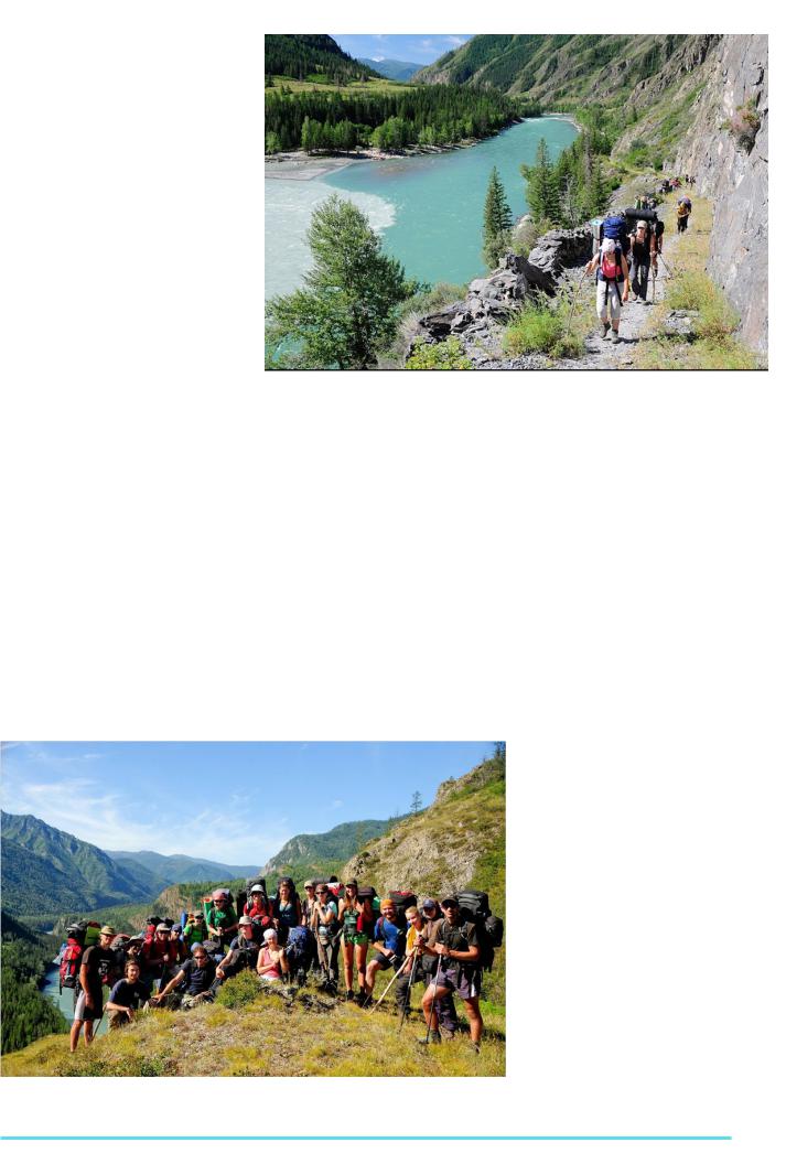
Figure 3: On the way – Source: Andreas Christoffer Lundegaard (EGEA Copenhagen) Argut river empties into the turquoise Katun
- Participants strengthened and improved their physical capabilities
After 20 days of heavy hiking across mountains (from 10 to 30 km per day across ragged terrain with almost 25-30 kg at a back) participants were getting stronger and stronger day after day (see figure 3).
- Intercultural communication
Participants from 9 countries were involved in the Altai Adventure (Austria, Slovakia, Latvia, Denmark, Slovenia, Italy, Germany, Finland and Russia). We lived together in tents for 23 days, talked a lot and discussed a lot – from political and historical issues to daily routine.
Acknowledgements
I would like to express my thanks to all the organizers and participants of this great event (see figure 4): Aino Kirillova, Yury Zyablov, Sergey Zworygin (organizers, EGEA Izhevsk), Andrea Giunti,
StanislavRuman,MarekKrajčuška,Daniela
Adamcova, Jana Butorova, Michal Ignaták (EGEA Bratislava), Andreas Christoffer Lundegaard (EGEA Copenhagen), Liisa Kallajoki, Eva-Maria Tillder (EGEA
Helsinki), Lea Ružič (EGEA Ljubljana), Sandra Juzane (EGEA Riga), Nils Ellwanger (EGEA Utrecht), Susanne Hanger, Verena Steidl (EGEA Wien). It would have been hard to get through the expedition and to fulfill our program successfully without the support of all members of the Altai Team!
References
1.Shahgedanova, M. 2003. The Physical Geography of Northern Eurorasia. Oxford University press: p.65.
2.Wikipedia, 2010. Altai Mountains. Viewed: 12th October, 2011: http://en.wikipedia.org/ wiki/Altai_Mountains
Figure 4: Altai Team – Source: Andreas Christoffer Lundegaard (EGEA Copenhagen)
33
The European Geographer, 8th Issue
Editorial Board of the
European Geographer
What is the European Geographer?
The European Geographer is a magazine for EGEAns who want to share their scientific work with other EGEAns and publish them on the EGEA website. It is also for those who want to widen their scientific and European horizons (and which geographer doesn't want to?) by reading the articles and exchanging opinions. It is also possible to write articles about congresses and other EGEA events in the European Geographer.
What does the Editorial Board do?
∞collecting articles for the latest issue
∞editing (i.e. checking and correcting) articles (including grammar & spelling mistakes, citation & references, structure, content, pictures)
∞put together and layout the magazine
∞organization tasks (including managing the budget, printing & distributing issues, advertisements of sponsors, etc.)
∞promoting the European Geographer within EGEA
What skills should you have?
What skills should you have?
-English skills (very important)
-organization skills
Check out our EGEA page http://www.egea.eu/entity/European Geographer.
If you have any questions contact us: egea.magazine@egea.eu
Facebook: http://www.facebook.com/EuropeanGeographer
34
Water - June 2012
35


 25
25

The European Geographer
Magazine of the European Geography Association for students and young geographers
8th issue June 2012
|
ISSN: 1605-6566 |
|
https://www.facebook.com/EuropeanGeographer |
© EGEA Association, Utrecht |
|
All rights reserved |
||
|