

Ключи к почвенной таксономии 2014
.pdfHorizons and Characteristics Diagnostic for the Higher Categories |
21 |
material. The material above the stone line is most likely transported, and the material below may be of different origin.
5. Inverse distribution of rock fragments.—A lithologic discontinuity is often indicated by an erratic distribution of rock fragments. The percentage of rock fragments decreases with increasing depth. This line of evidence is useful in areas of soils that have relatively unweathered rock fragments.
6. Rock fragment weathering rinds.—Horizons containing rock fragments with no rinds that overlie horizons containing rocks with rinds suggest that the upper material is in part depositional and not related to the lower part in time and perhaps in lithology.
7. Shape of rock fragments.—A soil with horizons containing angular rock fragments overlying horizons containing well rounded rock fragments may indicate a discontinuity. This line of evidence represents different mechanisms of transport (colluvial vs. alluvial) or even different transport distances.
8. Soil color.—Abrupt changes in color that are not the result of pedogenic processes can be used as indicators of discontinuity.
9. Micromorphological features.—Marked differences in the size and shape of resistant minerals in one horizon and not in another are indicators of differences in materials.
Use of Laboratory Data
Discontinuities are not always readily apparent in the field. In these cases laboratory data are necessary. Even with laboratory data, detecting discontinuities may be difficult. The decision is a qualitative or perhaps a partly quantitative
judgment. General concepts of lithology as a function of depth might include:
1. Laboratory data—visual scan.—The array of laboratory data is assessed in an attempt to determine if a fielddesignated discontinuity is corroborated and if any data show evidence of a discontinuity not observed in the field. One must sort changes in lithology from changes caused by pedogenic processes. In most cases the quantities of sand and coarser fractions are not altered significantly by soil-forming processes.
Therefore, an abrupt change in sand size or sand mineralogy is a clue to lithologic change. Gross soil mineralogy and the resistant mineral suite are other clues.
2. Data on a clay-free basis.—A common manipulation in assessing lithologic change is computation of sand and silt separates on a carbonate-free, clay-free basis (percent fraction, e.g., fine sand and very fine sand, divided by percent sand plus silt, times 100). Clay distribution is subject to pedogenic change and may either mask inherited lithologic differences or produce differences that are not inherited from lithology. The numerical array computed on a clay-free basis can be inspected visually or plotted as a function of depth.
Another aid used to assess lithologic changes is computation of the ratios of one sand separate to another. The ratios can
be computed and examined as a numerical array, or they can be plotted. The ratios work well if sufficient quantities of the two fractions are available. Low quantities magnify changes in ratios, especially if the denominator is low.
n Value
The n value (Pons and Zonneveld, 1965) characterizes the relation between the percentage of water in a soil under field conditions and its percentages of inorganic clay and humus.
The n value is helpful in predicting whether a soil can be grazed by livestock or can support other loads and in predicting what degree of subsidence would occur after drainage.
For mineral soil materials that are not thixotropic, the n value can be calculated by the following formula:
n = (A- 0.2R)/(L + 3H)
In this formula, A is the percentage of water in the soil in field condition, calculated on a dry-soil basis; R is the percentage of silt plus sand; L is the percentage of clay; and
H is the percentage of organic matter (percent organic carbon multiplied by 1.724).
Few data for calculations of the n value are available in the United States, but the critical n value of 0.7 can be
approximated closely in the field by a simple test of squeezing a soil sample in the palm of a hand. If the soil flows between the fingers with difficulty, the n value is between 0.7 and 1.0 (slightly fluid manner of failure class); if the soil flows easily between the fingers, the n value is 1 or more (moderately fluid or very fluid manner of failure class); and if no soil material flows through the fingers during full compression, the sample has an n value less than 0.7 (nonfluid manner of failure class).
Petroferric Contact
A petroferric (Gr. petra, rock, and L. ferrum, iron; implying ironstone) contact is a boundary between soil and a continuous layer of indurated material in which iron is an important cement and organic matter is either absent or present only in traces. The indurated layer must be continuous within the limits of each pedon, but it may be fractured if the average lateral distance between fractures is 10 cm or more. The fact that this ironstone layer contains little or no organic matter distinguishes it from a placic horizon and an indurated spodic horizon (ortstein), both of which contain organic matter.
Several features can aid in making the distinction between a lithic contact and a petroferric contact. First, a petroferric contact is roughly horizontal. Second, the material directly below a petroferric contact contains a high amount of iron
(normally 30 percent or more Fe2O3). Third, the ironstone sheets below a petroferric contact are thin; their thickness ranges
from a few centimeters to very few meters. Sandstone, on the other hand, may be thin or very thick, may be level-bedded or tilted, and may contain only a small percentage of Fe2O3. In the Tropics, the ironstone is generally more or less vesicular.
D
I
A

22 |
Keys to Soil Taxonomy |
Plinthite
Plinthite (Gr. plinthos, brick) is an iron-rich, humus-poor mixture of clay with quartz and other minerals. It commonly occurs as dark red redox concentrations that usually form platy, polygonal, or reticulate patterns. Plinthite changes irreversibly to an ironstone hardpan or to irregular aggregates on exposure to repeated wetting and drying, especially if it is also exposed to heat from the sun. The lower boundary of a zone in which plinthite occurs generally is diffuse or gradual, but it may be abrupt at a lithologic discontinuity.
Plinthite may occur as a constituent of a number of horizons, such as an epipedon, a cambic horizon, an argillic horizon, an oxic horizon, or a C horizon. It is one form of the material that has been called laterite. It normally forms in a horizon below the surface, but it may form at the surface in a seep area at the base of a slope.
From a genetic viewpoint, plinthite forms by segregation of iron. In many places iron probably has been added from other horizons or from the higher adjacent soils. Generally, plinthite forms in a horizon that is saturated with water for
some time during the year. Initially, iron is normally segregated in the form of soft, more or less clayey, red or dark red redox concentrations. These concentrations are not considered plinthite unless there has been enough segregation of iron to permit their irreversible hardening on exposure to repeated wetting and drying.
Plinthite is firm or very firm when the soil moisture content is near field capacity and hard when the moisture content is below the wilting point. Plinthite occurs as discrete bodies larger than 2 mm that can be separated from the matrix. A moist aggregate of plinthite will withstand moderate rolling between thumb and forefinger and is less than strongly cemented. Moist or air-dried plinthite will not slake when submerged in water even with gentle agitation. Plinthite does not harden irreversibly as a result of a single cycle of drying and rewetting. After a single drying, it will remoisten and then can be dispersed in large part if one shakes it in water with a dispersing agent.
In a moist soil, plinthite is soft enough to be cut with a spade. After irreversible hardening, it is no longer considered plinthite but is called ironstone. Indurated ironstone materials can be broken or shattered with a spade but cannot be dispersed if one shakes them in water with a dispersing agent.
A small amount of plinthite in the soil does not form a continuous phase; that is, the individual redox concentrations or aggregates are not connected with each other. If a large amount of plinthite is present, it may form a continuous phase. Individual aggregates of plinthite in a continuous phase are interconnected, and the spacing of cracks or zones that roots can enter is 10 cm or more.
If a continuous layer becomes indurated, it is a massive ironstone layer that has irregular, somewhat tubular inclusions of yellowish, grayish, or white, clayey material. If the layer is exposed, these inclusions may be washed out, leaving an ironstone that has many coarse, tubular pores.
Much that has been called laterite is included in the meaning of plinthite. Doughy and concretionary laterite that has not hardened is an example. Hardened laterite, whether it is vesicular or pisolitic, is not included in the definition of plinthite.
Resistant Minerals
Several references are made to resistant minerals in this taxonomy. Obviously, the stability of a mineral in the soil is a partial function of the soil moisture regime. Where resistant
minerals are referred to in the definitions of diagnostic horizons and of various taxa, a humid climate, past or present, is always assumed.
Resistant minerals are durable minerals in the 0.02 to
2.0 mm fraction. Examples are quartz, zircon, tourmaline, beryl, anatase, rutile, iron oxides and oxyhydroxides, 1:1 dioctahedral phyllosilicates (kandites), gibbsite, and hydroxyaluminum interlayered 2:1 minerals (Burt and Soil Survey Staff, 2014).
Slickensides
Slickensides are polished and grooved surfaces and generally have dimensions exceeding 5 cm. They are produced when one soil mass slides past another. Some slickensides occur at the lower boundary of a slip surface where a mass of soil moves downward on a relatively steep slope. Slickensides result directly from the swelling of clay minerals and shear failure. They are very common in swelling clays that undergo marked changes in moisture content.
Spodic Materials
Spodic materials form in an illuvial horizon that normally underlies a histic, ochric, or umbric epipedon or an albic horizon. In most undisturbed areas, spodic materials underlie an albic horizon. They may occur within an umbric epipedon or an Ap horizon.
A horizon consisting of spodic materials normally has an optical density of oxalate extract (ODOE) value of 0.25 or more, and that value is commonly at least 2 times as high as the
ODOE value in an overlying eluvial horizon. This increase in ODOE value indicates an accumulation of translocated organic materials in an illuvial horizon. Soils with spodic materials show evidence that organic materials and aluminum, with or without iron, have been moved from an eluvial horizon to an illuvial horizon.
Definition of Spodic Materials
Spodic materials are mineral soil materials that do not have all of the properties of an argillic or kandic horizon; are dominated by active amorphous materials that are illuvial and
are composed of organic matter and aluminum, with or without iron; and have both of the following:

Horizons and Characteristics Diagnostic for the Higher Categories |
23 |
1. ApH value in water (1:1) of 5.9 or less and an organiccarbon content of 0.6 percent or more; and
2. One or both of the following:
a. An overlying albic horizon that extends horizontally through 50 percent or more of each pedon and, directly under the albic horizon, colors, moist (crushed and smoothed sample), as follows:
(1) Hue of 5YR or redder; or
(2) Hue of 7.5YR, color value of 5 or less, and chroma of 4 or less; or
(3) Hue of 10YR or neutral and a color value and chroma of 2 or less; or
(4) A color of 10YR 3/1; or
b. With or without an albic horizon and one of the colors listed above or hue of 7.5YR, color value, moist, of 5 or less, and chroma of 5 or 6 (crushed and smoothed sample), and one or more of the following morphological or chemical properties:
(1) Cementation by organic matter and aluminum, with or without iron, in 50 percent or more of each pedon and a very firm or firmer rupture-resistance class in the cemented part; or
(2) 10 percent or more cracked coatings on sand grains; or
(3) Al plus 1/2 Fe percentages (by ammonium oxalate) totaling 0.50 or more, and half that amount or less in an overlying umbric (or subhorizon of an umbric) epipedon, ochric epipedon, or albic horizon; or
(4) An optical density of oxalate extract (ODOE) value of 0.25 or more, and a value half as high or lower in an overlying umbric (or subhorizon of an umbric) epipedon, ochric epipedon, or albic horizon.
Volcanic Glass
Volcanic glass is defined herein as optically isotropic translucent glass or pumice of any color. It includes glass, pumice, glass-coated crystalline minerals, glass aggregates, and glassy materials.
Volcanic glass is typically a dominant component in relatively unweathered tephra. Weathering and mineral transformation of volcanic glass can produce short-range-order minerals, such as allophane, imogolite, and ferrihydrite.
Volcanic glass content is the percent (by grain count) of glass, glass-coated mineral grains, glass aggregates, and glassy materials in the 0.02 to 2.0 mm fraction. Typically, the content is determined for one particle-size fraction (i.e., coarse silt, very fine sand, or fine sand) and used as an estimate of glass content in the 0.02 to 2.0 mm fraction.
Volcanic glass content is a criterion in classification of andic soil properties, subgroups with the formative element “vitr(i),” families with “ashy” substitutes for particle-size class, and the glassy mineralogy class.
Weatherable Minerals
Several references are made to weatherable minerals in this taxonomy. Obviously, the stability (i.e., ability to remain unaltered) of a mineral in a soil is a partial function of the soil moisture regime. Where weatherable minerals are referred to in the definitions of diagnostic horizons and of various taxa in this taxonomy, a humid climate, either present or past, is always assumed. Examples of the minerals that are included in
the meaning of weatherable minerals are all 2:1 phyllosilicates, chlorite, sepiolite, palygorskite, allophane, 1:1 trioctahedral phyllosilicates (serpentines), feldspars, feldspathoids, ferromagnesian minerals, volcanic glass, zeolites, dolomite, and apatite in the 0.02 to 2.0 mm fraction.
Obviously, this definition of the term “weatherable minerals” is restrictive. The intent is to include, in the definitions of diagnostic horizons and various taxa, only those weatherable minerals that are unstable in a humid climate compared to other minerals, such as quartz and 1:1 lattice clays, but that are more resistant to weathering than calcite. Calcite, carbonate aggregates, anhydrite, gypsum, and halite are not considered weatherable minerals because they are mobile in the soil.
Mobile minerals appear to be recharged in some otherwise strongly weathered soils.
Characteristics Diagnostic for Organic Soils
Following is a description of the characteristics that are used only with organic soils.
Kinds of Organic Soil Materials
Three different kinds of organic soil materials are distinguished in this taxonomy, based on the degree of decomposition of the plant materials from which the organic materials are derived. The three kinds are (1) fibric, (2) hemic, and (3) sapric. Because of the importance of fiber content in the definitions of these materials, fibers are defined before the kinds of organic soil materials.
Fibers
Fibers are pieces of plant tissue in organic soil materials (excluding live roots) that:
1. Are large enough to be retained on a 100-mesh sieve
(openings 0.15 mm across) when the materials are screened; and
D
I
A
24 |
Keys to Soil Taxonomy |
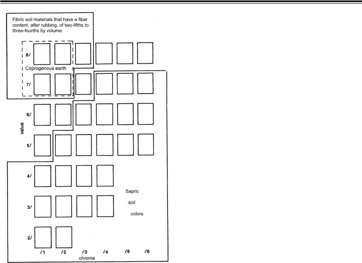
Figure 2.—Value and chroma of pyrophosphate solution of fibric and sapric soil materials.
2. Show evidence of the cellular structure of the plants from which they are derived; and
3. Either are 20 mm or less in their smallest dimension or are decomposed enough to be crushed and shredded with the fingers.
Pieces of wood that are larger than 20 mm in cross section and are so undecomposed that they cannot be crushed
and shredded with the fingers, such as large branches, logs, and stumps, are not considered fibers but are considered
wood fragments (comparable to rock fragments in mineral soils). Wood fragments may be in the soil or on the soil surface.
Fibric Soil Materials
Fibric soil materials are organic soil materials that either:
1. Contain three-fourths or more (by volume) fibers after rubbing, excluding wood fragments (defined above); or
2. Contain two-fifths or more (by volume) fibers after rubbing, excluding coarse fragments, and yield color values and chromas of 7/1, 7/2, 8/1, 8/2, or 8/3 (fig. 2) on white chromatographic or filter paper that is inserted into a paste made of the soil materials in a saturated sodium-pyrophosphate solution.
Hemic Soil Materials
Hemic (Gr. hemi, half; implying intermediate decomposition) soil materials are intermediate in their degree of decomposition between the less decomposed fibric and more decomposed sapric materials. Their morphological features give intermediate values for fiber content, bulk density, and water content.
Hemic soil materials are partly altered both physically and biochemically.
Sapric Soil Materials
Sapric (Gr. sapros, rotten) soil materials are the most highly decomposed of the three kinds of organic soil materials. They have the smallest amount of plant fiber, the highest bulk density, and the lowest water content on a dry-weight basis at saturation.
Sapric soil materials are commonly very dark gray to black. They are relatively stable; i.e., they change very little physically and chemically with time in comparison to other organic soil materials.
Sapric materials have the following characteristics:
1. The fiber content, after rubbing, is less than one-sixth (by volume), excluding wood fragments (defined above); and
2. The color of the sodium-pyrophosphate extract on white chromatographic or filter paper is below or to the right of a line drawn to exclude blocks 5/1, 6/2, and 7/3 (fig. 2). If few or no fibers can be detected and the color of the pyrophosphate extract is to the left of or above this line, the possibility that the material is limnic must be considered.
Humilluvic Material
Humilluvic material, i.e., illuvial humus, accumulates in the lower parts of some organic soils that are acid and have been drained and cultivated. The humilluvic material has a C14 age that is not older than the overlying organic materials. It has very high solubility in sodium pyrophosphate and rewets very slowly after drying. Most commonly, it accumulates near a contact with a sandy mineral horizon.
To be recognized as a differentia in classification, the humilluvic material must constitute one-half or more (by volume) of a layer 2 cm or more thick.
Kinds of Limnic Materials
The presence or absence of limnic deposits is taken into account in the higher categories of Histosols but not Histels.

Horizons and Characteristics Diagnostic for the Higher Categories |
25 |
The nature of such deposits is considered in the lower categories of Histosols. Limnic materials include both organic and inorganic materials that were either (1) deposited in water by precipitation or through the action of aquatic organisms, such as algae or diatoms, or (2) derived from underwater and floating aquatic plants and subsequently modified by aquatic animals. They include coprogenous earth (sedimentary peat), diatomaceous earth, and marl.
Coprogenous Earth
A layer of coprogenous earth (sedimentary peat) is a limnic layer that:
1. Contains many fecal pellets with diameters between a few hundredths and a few tenths of a millimeter; and
2. Has a color value of 4 or less, moist; and
3. Either forms a slightly viscous water suspension and is nonplastic or slightly plastic but not sticky, or shrinks upon drying, forming clods that are difficult to rewet and often tend to crack along horizontal planes; and
4. Either yields a saturated sodium-pyrophosphate extract on white chromatographic or filter paper that has a color value of 7 or more and chroma of 2 or less (fig. 2) or
has a cation-exchange capacity of less than 240 cmol(+) per kg organic matter (measured by loss on ignition), or both.
Diatomaceous Earth
A layer of diatomaceous earth is a limnic layer that:
1. If not previously dried, has a matrix color value of 3, 4, or 5, which changes irreversibly on drying as a result of the irreversible shrinkage of organic-matter coatings on diatoms (identifiable by microscopic, 440 X, examination of dry samples); and
2. Either yields a saturated sodium-pyrophosphate extract on white chromatographic or filter paper that has a color value of 8 or more and chroma of 2 or less or has a cation-exchange capacity of less than 240 cmol(+) per kg organic matter
(measured by loss on ignition), or both.
Marl
A layer of marl is a limnic layer that:
1. Has a color value of 5 or more, moist; and
2. Reacts with dilute HCl to evolve CO2.
The color of marl usually does not change irreversibly on drying because a layer of marl contains too little organic matter, even before it has been shrunk by drying, to coat the carbonate particles.
Thickness of Organic Soil Materials
(Control Section of Histosols and Histels)
The thickness of organic materials over limnic materials, mineral materials, water, or permafrost is used to define
Histosols and Histels.
For practical reasons, an arbitrary control section has been established for the classification of Histosols and Histels.
Depending on the kinds of soil material in the surface layers, the control section has a thickness of either 130 cm or 160 cm from the soil surface if there is no densic, lithic, or paralithic contact, thick layer of water, or permafrost within the respective limit. The thicker control section is used if the surface layers
to a depth of 60 cm either contain three-fourths or more fibers derived from Sphagnum, Hypnum, or other mosses or have
a bulk density of less than 0.1 g/cm3. Layers of water, which may be between a few centimeters and many meters thick in these soils, are considered to be the lower boundary of the control section only if the water extends below a depth of 130 or 160 cm, respectively.Adensic, lithic, or paralithic contact, if shallower than 130 or 160 cm, constitutes the lower boundary of the control section. In some soils the lower boundary is 25 cm below the upper limit of permafrost. An unconsolidated mineral substratum shallower than those limits does not change the lower boundary of the control section.
The control section of Histosols and Histels is divided somewhat arbitrarily into three tiers—surface, subsurface, and bottom tiers.
Surface Tier
The surface tier of a Histosol or Histel extends from the soil surface to a depth of 60 cm if either (1) the materials within that depth are fibric and three-fourths or more of the fiber volume is derived from Sphagnum or other mosses or (2) the materials have a bulk density of less than 0.1 g/cm3. Otherwise, the surface tier extends from the soil surface to a depth of 30 cm.
Some organic soils have a mineral surface layer less than 40 cm thick as a result of flooding, volcanic eruptions, additions of mineral materials to increase soil strength or reduce the hazard of frost, or other causes. If such a mineral layer is less than 30 cm thick, it constitutes the upper part of the surface tier; if it is 30 to 40 cm thick, it constitutes the whole surface tier and part of the subsurface tier.
Subsurface Tier
The subsurface tier is normally 60 cm thick. If the control section ends at a shallower depth (at a densic, lithic, or paralithic contact or a water layer or in permafrost), however, the subsurface tier extends from the lower boundary of the surface tier to the lower boundary of the control section. It includes any unconsolidated mineral layers that may be present within those depths.
D
I
A

26 |
Keys to Soil Taxonomy |
Bottom Tier
The bottom tier is 40 cm thick unless the control section has its lower boundary at a shallower depth (at a densic, lithic, or paralithic contact or a water layer or in permafrost).
Thus, if the organic materials are thick, there are two possible thicknesses of the control section, depending on the presence or absence and the thickness of a surface mantle of fibric moss or other organic material that has a low bulk density (less than 0.1 g/cm3). If the fibric moss extends to a depth of 60 cm and is the dominant material within this depth (three-fourths or more of the volume), the control section is 160 cm thick. If the fibric moss is thin or absent, the control section extends to a depth of 130 cm.
Horizons and Characteristics Diagnostic for Both Mineral and Organic Soils
Following are descriptions of the horizons and characteristics that are diagnostic for both mineral and organic soils.
Aquic Conditions
Soils with aquic (L. aqua, water) conditions are those that currently undergo continuous or periodic saturation and reduction. The presence of these conditions is indicated by redoximorphic features, except in Histosols and Histels, and can be verified by measuring saturation and reduction, except
in artificially drained soils.Artificial drainage is defined here as the removal of free water from soils having aquic conditions by surface mounding, ditches, or subsurface tiles or the prevention of surface or ground water from reaching the soils by dams, levees, surface pumps, or other means. In these soils water table levels and/or their duration are changed significantly in connection with specific types of land use. Upon removal of the drainage practices, aquic conditions would return. In the keys, artificially drained soils are included with soils that have aquic conditions.
Elements of aquic conditions are as follows:
1. Saturation is characterized by zero or positive pressure in the soil water and can generally be determined by observing free water in an unlined auger hole. Problems may arise, however, in clayey soils with peds, where an unlined auger hole may fill with water flowing along faces of peds while the soil matrix is and remains unsaturated (bypass flow). Such free water may incorrectly suggest the presence of a water table, while the actual water table occurs at greater depth. Use of wellsealed piezometers or tensiometers is therefore recommended for measuring saturation. Problems may still occur, however,
if water runs into piezometer slits near the bottom of the piezometer hole or if tensiometers with slowly reacting manometers are used. The first problem can be overcome by using piezometers with smaller slits and the second by using
transducer tensiometry, which reacts faster than manometers. Soils are considered wet if they have pressure heads greater than -1 kPa. Only macropores, such as cracks between peds or channels, are then filled with air, while the soil matrix is usually still saturated. Obviously, exact measurements of the wet
state can be obtained only with tensiometers. For operational purposes, the use of piezometers is recommended as a standard method.
The duration of saturation required for creating aquic conditions varies, depending on the soil environment, and is not specified.
Three types of saturation are defined:
a. Endosaturation.—The soil is saturated with water in all layers from the upper boundary of saturation to a depth of 200 cm or more from the mineral soil surface.
b. Episaturation.—The soil is saturated with water in one or more layers within 200 cm of the mineral soil surface and also has one or more unsaturated layers, with an upper
boundary above a depth of 200 cm, below the saturated layer. The zone of saturation, i.e., the water table, is perched on top of a relatively impermeable layer.
c. Anthric saturation.—This term refers to a special kind of aquic condition that occurs in soils that are cultivated and irrigated (flood irrigation). Soils with anthraquic conditions must meet the requirements for aquic conditions and in addition have both of the following:
(1) A tilled surface layer and a directly underlying slowly permeable layer that has, for 3 months or more in normal years, both:
(a) Saturation and reduction; and
(b) Chroma of 2 or less in the matrix; and
(2) A subsurface horizon with one or more of the following:
(a) Redox depletions with a color value of 4 or more, moist, and chroma of 2 or less in macropores; or
(b) Redox concentrations of iron and/or manganese; or
(c) 2 times or more the amount of iron (extractable by dithionite-citrate) than is contained in the tilled surface layer.
2. The degree of reduction in a soil can be characterized by the direct measurement of redox potentials. Direct measurements should take into account chemical equilibria as expressed by stability diagrams in standard soil textbooks. Reduction and oxidation processes are also a function of soil pH. Obtaining accurate measurements of the degree of
reduction in a soil is difficult. In the context of this taxonomy, however, only a degree of reduction that results in reduced iron is considered, because it produces the visible redoximorphic

Horizons and Characteristics Diagnostic for the Higher Categories |
27 |
features that are identified in the keys.Asimple field test is available to determine if reduced iron ions are present. A freshly broken surface of a field-wet soil sample is treated with alpha,alpha-dipyridyl in neutral, 1N ammonium acetate solution. The appearance of a strong red color on the freshly broken surface indicates the presence of reduced iron ions (i.e., Fe2+).Apositive reaction to the alpha,alpha-dipyridyl field test for ferrous iron (Childs, 1981) may be used to
confirm the existence of reducing conditions and is especially useful in situations where, despite saturation, normal morphological indicators of such conditions are either absent or obscured (as by the dark colors characteristic of melanic great groups). A negative reaction, however, does not imply that reducing conditions are always absent. It may only mean that the level of free iron in the soil is below the sensitivity limit of the test or that the soil is in an oxidized phase at the time of testing. For soils with very low levels of iron, the use of a field test such as Indicator of Reduction in Soils (IRIS) tubes painted with ferric iron may be warranted in order to document reducing conditions. Use of alpha,alpha-dipyridyl in a 10 percent solution of aceticacid is not recommended because the acid is likely to change soil conditions, for example, by dissolving CaCO3.
The duration of reduction required for creating aquic conditions is not specified.
3. Redoximorphic features associated with wetness result from alternating periods of reduction and oxidation of iron and manganese compounds in the soil. Reduction occurs during saturation with water, and oxidation occurs when the soil is not saturated. The reduced iron and manganese ions are mobile and may be transported by water as it moves through the soil. Certain redox patterns occur as a function of the patterns in which the ion-carrying water moves through the soil and as
a function of the location of aerated zones in the soil. Redox patterns are also affected by the fact that manganese is reduced more rapidly than iron, while iron oxidizes more rapidly upon aeration. Characteristic color patterns are created by these processes. The reduced iron and manganese ions may be removed from a soil if vertical or lateral fluxes of water occur, in which case there is no iron or manganese precipitation in that soil. Wherever the iron and manganese are oxidized and precipitated, they form either soft masses or hard concretions or nodules. Movement of iron and manganese as a result of redox processes in a soil may result in redoximorphic features that are defined as follows:
a. Redox concentrations.—These are zones of apparent accumulation of Fe-Mn oxides, including:
(1) Nodules and concretions, which are cemented bodies that can be removed from the soil intact. Concretions
are distinguished from nodules on the basis of internal organization. A concretion typically has concentric layers that are visible to the naked eye. Nodules do not have visible organized internal structure. Boundaries
commonly are diffuse if formed in situ and sharp after pedoturbation. Sharp boundaries may be relict features in some soils; and
(2) Masses, which are noncemented concentrations of substances within the soil matrix; and
(3) Pore linings, i.e., zones of accumulation along pores that may be either coatings on pore surfaces or impregnations from the matrix adjacent to the pores.
b. Redox depletions.—These are zones of low chroma
(chromas less than those in the matrix) where either FeMn oxides alone or both Fe-Mn oxides and clay have been stripped out, including:
(1) Iron depletions, i.e., zones that contain low amounts of Fe and Mn oxides but have a clay content similar to that of the adjacent matrix (often referred to as albans or neoalbans); and
(2) Clay depletions, i.e., zones that contain low amounts of Fe, Mn, and clay (often referred to as silt coatings or skeletans).
c. Reduced matrix.—This is a soil matrix that has low chroma in situ but undergoes a change in hue or chroma within 30 minutes after the soil material has been exposed to air.
d. In soils that have no visible redoximorphic features, a reaction to an alpha,alpha-dipyridyl solution satisfies the requirement for redoximorphic features.
Field experience indicates that it is not possible to define a specific set of redoximorphic features that is uniquely characteristic of all of the taxa in one particular category.
Therefore, color patterns that are unique to specific taxa are referenced in the keys.
Anthraquic conditions are a variant of episaturation and are associated with controlled flooding (for such crops as wetland rice and cranberries), which causes reduction processes in the saturated, puddled surface soil and oxidation of reduced and mobilized iron and manganese in the unsaturated subsoil.
Cryoturbation
Cryoturbation (frost churning) is the mixing of the soil matrix within the pedon that results in irregular or broken horizons, involutions, accumulation of organic matter on the permafrost table, oriented rock fragments, and silt caps on rock fragments.
Densic Contact
Adensic (L. densus, thick) contact is a contact between soil and densic materials (defined below). It has no cracks, or the spacing of cracks that roots can enter is 10 cm or more.
D
I
A

28 |
Keys to Soil Taxonomy |
Densic Materials
Densic materials are relatively unaltered materials (do not meet the requirements for any other named diagnostic horizons or any other diagnostic soil characteristic) that have a noncemented rupture-resistance class. The bulk density or the organization is such that roots cannot enter, except in
cracks. These are mostly earthy materials, such as till, volcanic mudflows, and some mechanically compacted materials, for example, mine spoils. Some noncemented rocks can be densic materials if they are dense or resistant enough to keep roots from entering, except in cracks.
Densic materials are noncemented and thus differ from paralithic materials and the material below a lithic contact, both of which are cemented.
Densic materials have, at their upper boundary, a densic contact if they have no cracks or if the spacing of cracks that roots can enter is 10 cm or more. These materials can be used to differentiate soil series if the materials are within the series control section.
Gelic Materials
Gelic materials are mineral or organic soil materials that show evidence of cryoturbation (frost churning) and/or ice segregation in the active layer (seasonal thaw layer) and/or the upper part of the permafrost. Cryoturbation is manifested by irregular and broken horizons, involutions, accumulation of organic matter on top of and within the permafrost, oriented rock fragments, and silt-enriched layers. The characteristic structures associated with gelic materials include platy, blocky, or granular macrostructures; the structural results of sorting; and orbiculic, conglomeric, banded, or vesicular microfabrics. Ice segregation is manifested by ice lenses, vein ice, segregated ice crystals, and ice wedges. Cryopedogenic processes that lead to gelic materials are driven by the physical volume change of water to ice, moisture migration along a thermal gradient in the frozen system, or thermal contraction of the frozen material by continued rapid cooling.
Glacic Layer
A glacic layer is massive ice or ground ice in the form of ice lenses or wedges. The layer is 30 cm or more thick and contains
75 percent or more visible ice.
Lithic Contact
A lithic contact is the boundary between soil and a coherent underlying material. Except in Ruptic-Lithic subgroups, the underlying material must be virtually continuous within the limits of a pedon. Cracks that can be penetrated by roots
are few, and their horizontal spacing is 10 cm or more. The underlying material must be sufficiently coherent when moist to make hand-digging with a spade impractical, although the material may be chipped or scraped with a spade. The material
below a lithic contact must be in a strongly cemented or more cemented rupture-resistance class. Commonly, the material is indurated. The underlying material considered here does not include diagnostic soil horizons, such as a duripan or a petrocalcic horizon.
A lithic contact is diagnostic at the subgroup level if it is within 125 cm of the mineral soil surface in Oxisols and within
50 cm of the mineral soil surface in all other mineral soils. In Gelisols composed mainly of organic soil materials, the lithic contact is diagnostic at the subgroup level if it is within 50 cm of the soil surface in Folistels or within 100 cm of the soil surface in Fibristels, Hemistels, and Sapristels. In Histosols the lithic contact must be at the lower boundary of the control section to be recognized at the subgroup level.
Paralithic Contact
Aparalithic (lithic-like) contact is a contact between soil and paralithic materials (defined below) where the paralithic materials have no cracks or the spacing of cracks that roots can enter is 10 cm or more.
Paralithic Materials
Paralithic materials are relatively unaltered materials (do not meet the requirements for any other named diagnostic horizons or any other diagnostic soil characteristic) that have an extremely weakly cemented to moderately cemented rupture-
resistance class. Cementation, bulk density, and the organization are such that roots cannot enter, except in cracks. Paralithic materials have, at their upper boundary, a paralithic contact if they have no cracks or if the spacing of cracks that roots can enter is 10 cm or more. Commonly, these materials are partially weathered bedrock or weakly consolidated bedrock, such as sandstone, siltstone, or shale. Paralithic materials can be used to differentiate soil series if the materials are within the series control section. Fragments of paralithic materials 2.0 mm or more in diameter are referred to as pararock fragments.
Permafrost
Permafrost is defined as a thermal condition in which a material (including soil material) remains below 0 oC for 2 or more years in succession. Those gelic materials having permafrost contain the unfrozen soil solution that drives cryopedogenic processes. Permafrost may be impregnated by ice or, in the case of insufficient interstitial water, may be dry.
The frozen layer has a variety of ice lenses, vein ice, segregated ice crystals, and ice wedges. The permafrost table is in dynamic equilibrium with the environment.
Soil Moisture Regimes
The term “soil moisture regime” refers to the presence or absence either of ground water or of water held at a tension of less than 1500 kPa in the soil or in specific horizons during

Horizons and Characteristics Diagnostic for the Higher Categories |
29 |
periods of the year. Water held at a tension of 1500 kPa or more is not available to keep most mesophytic plants alive. The availability of water is also affected by dissolved salts. If a soil is saturated with water that is too salty to be available to
most plants, it is considered salty rather than dry. Consequently, a horizon is considered dry when the moisture tension is
1500 kPa or more and is considered moist if water is held at a tension of less than 1500 kPa but more than zero. A soil may be continuously moist in some or all horizons either throughout the year or for some part of the year. It may be either moist
in winter and dry in summer or the reverse. In the Northern Hemisphere, summer refers to June, July, and August and winter refers to December, January, and February.
Normal Years
In the discussions that follow and throughout the keys, the term “normal years” is used.Anormal year is defined as a year that has:
1. Annual precipitation that is plus or minus one standard deviation of the long-term (30 years or more) mean annual precipitation; and
2. Mean monthly precipitation that is plus or minus one standard deviation of the long-term monthly precipitation for 8 of the 12 months.
For the most part, normal years can be calculated from the mean annual precipitation; however, when catastrophic events occur during a year, the standard deviations of the monthly means should also be calculated. The term “normal years” replaces the terms “most years” and “6 out of 10 years,” which were used in the previous edition of Soil Taxonomy (Soil
Survey Staff, 1975). When precipitation data are evaluated to determine if the criterion for the presence of aquic conditions, or number of days that the moisture control section is moist, or number of days that some part of the soil is saturated has been met, it is permissible to include data from periods with below normal rainfall. Similarly, when precipitation data are evaluated to determine if the criterion for the number of days that the moisture control section is dry has been met, it is permissible to include data from periods with above normal rainfall. It is assumed that if the criteria are met during these periods, they will also be met during normal years.
Soil Moisture Control Section
The intent in defining the soil moisture control section is to facilitate estimation of soil moisture regimes from climatic data. The upper boundary of this control section is the depth to which a dry (tension of more than 1500 kPa, but not air-dry) soil will be moistened by 2.5 cm of water within 24 hours. The lower boundary is the depth to which a dry soil will be moistened by
7.5 cm of water within 48 hours. These depths do not include the depth of moistening along any cracks or animal burrows that are open to the surface.
If 7.5 cm of water moistens the soil to a densic, lithic, paralithic, or petroferric contact or to a petrocalcic or petrogypsic horizon or a duripan, the contact or the upper boundary of the cemented horizon constitutes the lower boundary of the soil moisture control section. If a soil is moistened to one of these contacts or horizons by 2.5 cm of water, the soil moisture control section is the boundary of the contact itself. The control section of such a soil is considered moist if the contact or upper boundary of the cemented horizon has a thin film of water. If that upper boundary is dry, the control section is considered dry.
The moisture control section of a soil extends approximately
(1)from 10 to 30 cm below the soil surface if the particle-size class of the soil is fine-loamy, coarse-silty, fine-silty, or clayey;
(2)from 20 to 60 cm if the particle-size class is coarse-loamy; and (3) from 30 to 90 cm if the particle-size class is sandy. If the soil contains rock and pararock fragments that do not absorb and release water, the limits of the moisture control section
are deeper. The limits of the soil moisture control section are affected not only by the particle-size class but also by
differences in soil structure or pore-size distribution or by other factors that influence the movement and retention of water in the soil.
Classes of Soil Moisture Regimes
The soil moisture regimes are defined in terms of the level of ground water and in terms of the seasonal presence or absence of water held at a tension of less than 1500 kPa in the moisture control section. It is assumed in the definitions that the soil supports whatever vegetation it is capable of supporting, i.e., crops, grass, or native vegetation, and that the amount of stored moisture is not being increased by irrigation or fallowing. These cultural practices affect the soil moisture conditions as long as they are continued.
Aquic soil moisture regime.—The aquic (L. aqua, water) soil moisture regime is a reducing regime in a soil that is virtually free of dissolved oxygen because it is saturated by water. Some soils are saturated with water at times while dissolved oxygen is present, either because the water is moving or because the environment is unfavorable for micro-organisms
(e.g., if the temperature is less than 1 oC); such a regime is not considered aquic.
It is not known how long a soil must be saturated before it is said to have an aquic soil moisture regime, but the duration must be at least a few days, because it is implicit in the concept that dissolved oxygen is virtually absent. Because dissolved oxygen is removed from ground water by respiration of micro-
organisms, roots, and soil fauna, it is also implicit in the concept that the soil temperature is above biologic zero for some time while the soil is saturated. Biologic zero is defined as 5 oC in this taxonomy. In some of the very cold regions of the world, however, biological activity occurs at temperatures below 5 oC.
Very commonly, the level of ground water fluctuates with the seasons; it is highest in the rainy season or in fall, winter, or
D
I
A

30 |
Keys to Soil Taxonomy |
spring if cold weather virtually stops evapotranspiration. There are soils, however, in which the ground water is always at or very close to the surface. Examples are soils in tidal marshes or in closed, landlocked depressions fed by perennial streams.
Such soils are considered to have a peraquic soil moisture regime.
Aridic and torric (L. aridus, dry, and L. torridus, hot and dry) soil moisture regimes.—These terms are used for the same moisture regime but in different categories of the taxonomy.
In the aridic (torric) soil moisture regime, the moisture control section is, in normal years:
1. Dry in all parts for more than half of the cumulative days per year when the soil temperature at a depth of 50 cm below the soil surface is above 5 oC; and
2. Moist in some or all parts for less than 90 consecutive days when the soil temperature at a depth of 50 cm below the soil surface is above 8 oC.
Soils that have an aridic (torric) soil moisture regime normally occur in areas of arid climates. A few are in areas of semiarid climates and either have physical properties that keep them dry, such as a crusty surface that virtually precludes the infiltration of water, or are on steep slopes where runoff is high.
There is little or no leaching in this soil moisture regime, and soluble salts accumulate in the soils if there is a source.
The limits set for soil temperature exclude from these soil moisture regimes soils in the very cold and dry polar regions and in areas at high elevations. Such soils are considered to have anhydrous conditions (defined earlier).
Udic soil moisture regime.—The udic (L. udus, humid) soil moisture regime is one in which the soil moisture control section is not dry in any part for as long as 90 cumulative days in normal years. If the mean annual soil temperature is lower than 22 oC and if the mean winter and mean summer soil temperatures at a depth of 50 cm below the soil surface differ by 6 oC or more, the soil moisture control section, in normal years, is dry in all parts for less than 45 consecutive days in the 4 months following the summer solstice. In addition, the udic soil moisture regime requires, except for short periods, a threephase system, solid-liquid-gas, in part or all of the soil moisture control section when the soil temperature is above 5 oC.
The udic soil moisture regime is common to the soils of humid climates that have well distributed rainfall; have enough rain in summer so that the amount of stored moisture plus rainfall is approximately equal to, or exceeds, the amount of evapotranspiration; or have adequate winter rains to recharge the soils and cool, foggy summers, as in coastal areas. Water moves downward through the soils at some time in normal years.
In climates where precipitation exceeds evapotranspiration in all months of normal years, the moisture tension rarely reaches 100 kPa in the soil moisture control section, although there are
occasional brief periods when some stored moisture is used. The water moves through the soil in all months when it is not frozen. Such an extremely wet soil moisture regime is called perudic
(L. per, throughout in time, and L. udus, humid). In the names of most taxa, the formative element “ud” is used to indicate either a udic or a perudic regime; the formative element “per” is used in selected taxa.
Ustic soil moisture regime.—The ustic (L. ustus, burnt; implying dryness) soil moisture regime is intermediate between the aridic regime and the udic regime. Its concept is one of moisture that is limited but is present at a time when conditions are suitable for plant growth. The concept of the ustic soil moisture regime is not applied to soils that have permafrost
(defined above).
If the mean annual soil temperature is 22 oC or higher or if the mean summer and winter soil temperatures differ by less than 6 oC at a depth of 50 cm below the soil surface, the soil moisture control section in areas of the ustic soil moisture regime is dry in some or all parts for 90 or more cumulative days in normal years. It is moist, however, in some part either for more than 180 cumulative days per year or for 90 or more consecutive days.
If the mean annual soil temperature is lower than 22 oC and if the mean summer and winter soil temperatures differ by
6 oC or more at a depth of 50 cm below the soil surface, the soil moisture control section in areas of the ustic soil moisture regime is dry in some or all parts for 90 or more cumulative days in normal years, but it is not dry in all parts for more than half of the cumulative days when the soil temperature at a depth of 50 cm is higher than 5 oC. If in normal years the moisture control section is moist in all parts for 45 or more consecutive days in the 4 months following the winter solstice, the moisture control section is dry in all parts for less than 45 consecutive days in the 4 months following the summer solstice.
In tropical and subtropical regions that have a monsoon climate with either one or two dry seasons, summer and winter seasons have little meaning. In those regions the soil moisture regime is ustic if there is at least one rainy season of 3 months or more. In temperate regions of subhumid or semiarid climates, the rainy seasons are usually spring and summer or spring and fall, but never winter. Native plants are mostly annuals or plants that have a dormant period while the soil is dry.
Xeric soil moisture regime.—The xeric (Gr. xeros, dry) soil moisture regime is the typical moisture regime in areas of
Mediterranean climates, where winters are moist and cool and summers are warm and dry. The moisture, which falls during the winter, when potential evapotranspiration is at a minimum, is particularly effective for leaching. In areas of a xeric soil moisture regime, the soil moisture control section, in normal years, is dry in all parts for 45 or more consecutive days in the 4 months following the summer solstice and moist in all parts for 45 or more consecutive days in the 4 months following the winter solstice. Also, in normal years, the moisture control section is moist in some part for more than half of the