

Ключи к почвенной таксономии 2014
.pdfHorizons and Characteristics Diagnostic for the Higher Categories |
11 |
(b) The lower boundary of the deepest of an argillic, cambic, natric, oxic, or spodic horizon; or
b. 10 cm if the epipedon has a texture class finer than loamy fine sand (when mixed) and it is directly above a densic, lithic, or paralithic contact, a petrocalcic horizon, or a duripan; or
c. 18 to 25 cm and the thickness is one-third or more of the total thickness between the mineral soil surface and:
(1) The upper boundary of the shallowest of any identifiable secondary carbonates or a calcic horizon, petrocalcic horizon, duripan, or fragipan; and/or
(2) The lower boundary of the deepest of an argillic, cambic, natric, oxic, or spodic horizon; or
d. 18 cm if none of the above conditions apply; and
7. Some part of the epipedon is moist for 90 days or more
(cumulative) in normal years during times when the soil temperature at a depth of 50 cm below the soil surface is 5 oC or higher, if the soil is not irrigated; and
8. The n value (defined below) is less than 0.7; and
9. The umbric epipedon does not have the artifacts, spade marks, and locally raised landforms that are characteristics of the plaggen epipedon.
Diagnostic Subsurface Horizons
The horizons described in this section form below the surface of the soil, although in some areas they form directly below a layer of leaf litter. They are composed of mineral soil material. They may be exposed at the surface by truncation of the soil. Some of these horizons are designated as B horizons by many, but not all, pedologists and others are generally designated as parts of A or E horizons.
Agric Horizon
The agric horizon is an illuvial horizon that has formed under cultivation and contains significant amounts of illuvial silt, clay, and humus.
Required Characteristics
The agric horizon is directly below an Ap horizon and has a thickness of 10 cm or more, and either:
1. 5 percent or more (by volume) wormholes, including coatings that are 2 mm or more thick and have a color value of 4 or less, moist, and chroma of 2 or less; or
2. 5 percent or more (by volume) lamellae that have a thickness of 5 mm or more and have a color value of 4 or less, moist, and chroma of 2 or less.
Albic Horizon
The albic horizon is an eluvial horizon, 1 cm or more thick, that has 85 percent or more (by volume) albic materials
(defined below). It generally occurs below anAhorizon but may be at the mineral soil surface. Under the albic horizon there generally is an argillic, cambic, kandic, natric, or spodic horizon or a fragipan (defined below). The albic horizon may lie between a spodic horizon and either a fragipan or an argillic horizon, or it may be between an argillic or kandic horizon and a fragipan. It may lie between a mollic epipedon and an argillic or natric horizon or between a cambic horizon and an argillic, kandic, or natric horizon or a fragipan. The albic horizon may separate horizons that, if they were together, would meet the requirements for a mollic epipedon. It may separate lamellae that together meet the requirements for an argillic horizon.
These lamellae are not considered to be part of the albic horizon.
Anhydritic Horizon
The anhydritic horizon is a horizon in which anhydrite has accumulated through neoformation or transformation to a
significant extent. It typically occurs as a subsurface horizon. It commonly occurs in conjunction with a salic horizon (defined below).
Required Characteristics
The anhydritic horizon meets all of the following requirements:
1. Is 15 cm or more thick; and
2. Is 5 percent or more (by weight) anhydrite; and
3. Has hue of 5Y, chroma (moist and dry) of 1 or 2, and value of 7 or 8; and
4. Has a product of thickness, in cm, multiplied by the anhydrite content (percent by weight) of 150 or more (thus, a horizon 30 cm thick that is 5 percent anhydrite qualifies as an anhydritic horizon); and
5. Has anhydrite as the predominant calcium sulfate mineral with gypsum either absent or present only in minor amounts.
Argillic Horizon
An argillic horizon is normally a subsurface horizon with a significantly higher percentage of phyllosilicate clay than the overlying soil material. It shows evidence of clay illuviation.
The argillic horizon forms below the soil surface, but it may be exposed at the surface later by erosion.
Required Characteristics
1. All argillic horizons must meet both of the following requirements:
D
I
A

12 |
Keys to Soil Taxonomy |
a. One of the following:
(1) If the argillic horizon meets the particle-size class criteria for coarse-loamy, fine-loamy, coarse-silty, finesilty, fine, or very-fine or is loamy or clayey, including skeletal counterparts, it must be at least 7.5 cm thick or at least one-tenth as thick as the sum of the thickness of all overlying horizons, whichever is greater; or
(2) If the argillic horizon meets the sandy or sandyskeletal particle-size criteria, it must be at least 15 cm thick; or
(3) If the argillic horizon is composed entirely of lamellae, the combined thickness of the lamellae that are 0.5 cm or more thick must be 15 cm or more; and
b. Evidence of clay illuviation in at least one of the following forms:
(1) Oriented clay bridging the sand grains; or
(2) Clay films lining pores; or
(3) Clay films on both vertical and horizontal surfaces of peds; or
(4) Thin sections with oriented clay bodies that are more than 1 percent of the section; or
(5) If the coefficient of linear extensibility is 0.04 or higher and the soil has distinct wet and dry seasons, then the ratio of fine clay to total clay in the illuvial horizon is greater by 1.2 times or more than the ratio in the eluvial horizon; and
2. If an eluvial horizon remains and there is no lithologic discontinuity between it and the illuvial horizon and no plow layer directly above the illuvial layer, then the illuvial horizon must contain more total clay than the eluvial horizon within a vertical distance of 30 cm or less, as follows:
a. If any part of the eluvial horizon has less than 15 percent total clay in the fine-earth fraction, the argillic horizon must contain at least 3 percent (absolute) more clay (10 percent versus 13 percent, for example); or
b. If the eluvial horizon has 15 to 40 percent total clay in the fine-earth fraction, the argillic horizon must have at least
1.2 times more clay than the eluvial horizon; or
c. If the eluvial horizon has 40 percent or more total clay in the fine-earth fraction, the argillic horizon must contain at least 8 percent (absolute) more clay (42 percent versus 50 percent, for example).
Calcic Horizon
The calcic horizon is an illuvial horizon in which secondary calcium carbonate or other carbonates have accumulated to a significant extent.
Required Characteristics
The calcic horizon:
1. Is 15 cm or more thick; and
2. Has one or more of the following:
a. 15 percent or more (by weight, fine-earth fraction) CaCO3 equivalent, and its CaCO3 equivalent is 5 percent or more (absolute) higher than that of an underlying horizon; or
b. 15 percent or more (by weight, fine-earth fraction) CaCO3 equivalent and 5 percent or more (by volume) identifiable secondary carbonates; or
c. 5 percent or more (by weight, fine-earth fraction) calcium carbonate equivalent and:
(1) Has less than 18 percent clay in the fine-earth fraction; and
(2) Meets the criteria for a sandy, sandy-skeletal, coarseloamy, or loamy-skeletal particle-size class† (defined in chapter 17); and
(3) Has 5 percent or more (by volume) identifiable secondary carbonates or a calcium carbonate equivalent (by weight, fine-earth fraction) that is 5 percent or more
(absolute) higher than that of an underlying horizon; and
3. Is not cemented or indurated in any part by carbonates, with or without other cementing agents, or is cemented in some part and the cemented part satisfies one of the following:
a. It is characterized by so much lateral discontinuity that roots can penetrate through noncemented zones or along vertical fractures with a horizontal spacing of less than 10 cm; or
b. The cemented layer is less than 1 cm thick and consists of a laminar cap underlain by a lithic or paralithic contact; or
c. The cemented layer is less than 10 cm thick.
Cambic Horizon
A cambic horizon is the result of physical alterations, chemical transformations, or removals or of a combination of two or more of these processes.
Required Characteristics
The cambic horizon is an altered horizon 15 cm or more thick. If it is composed of lamellae, the combined thickness of the lamellae must be 15 cm or more. In addition, the cambic horizon must meet all of the following:
† Particle-size classes are used in this required characteristic as a convenient proxy for many possible combinations of USDAtexture class and texture modifier and do not imply that the soil meeting this option for the diagnostic horizon also meets the particle-size class criteria in the family classification.

Horizons and Characteristics Diagnostic for the Higher Categories |
13 |
1. Has a texture class of very fine sand, loamy very fine sand, or finer; and
2. Shows evidence of alteration in one of the following forms:
a. Aquic conditions within 50 cm of the soil surface or artificial drainage and all of the following:
(1) Soil structure or the absence of rock structure, including fine stratifications (5 mm or less thick), in more than one-half of the volume; and
(2) Colors that do not change on exposure to air; and
(3) Dominant color, moist, on faces of peds or in the matrix as follows:
(a) Value of 3 or less and neutral colors with no hue (N) and zero chroma; or
(b) Value of 4 or more and chroma of 1 or less; or
(c) Any value, chroma of 2 or less, and redox concentrations; or
b. Does not have the combination of aquic conditions within 50 cm of the soil surface or artificial drainage and colors, moist, as defined in item 2-a-(3) above, and has soil structure or the absence of rock structure, including fine stratifications (5 mm or less thick), in more than one-half of the volume and one or more of the following properties:
(1) Higher chroma, higher value, redder hue, or higher clay content than the underlying horizon or an overlying horizon; or
(2) Evidence of the removal of carbonates or gypsum; and
3. Has properties that do not meet the requirements for an anthropic, histic, folistic, melanic, mollic, plaggen, or umbric epipedon, a duripan or fragipan, or an argillic, calcic, gypsic, natric, oxic, petrocalcic, petrogypsic, placic, salic, spodic, or sulfuric horizon; and
4. Is not part of an Ap horizon and does not have a brittle manner of failure in more than 60 percent of the matrix.
Duripan
Aduripan is a silica-cemented subsurface horizon with or without auxiliary cementing agents. It can occur in conjunction with a petrocalcic horizon.
Required Characteristics
A duripan must meet all of the following requirements:
1. The pan is cemented or indurated in more than 50 percent of the volume of some horizon; and
2. The pan shows evidence of the accumulation of opal or other forms of silica, such as laminar caps, coatings, lenses,
partly filled interstices, bridges between sand-sized grains, or coatings on rock and pararock fragments; and
3. Less than 50 percent of the volume of air-dry fragments slakes in 1N HCl even during prolonged soaking, but more than 50 percent slakes in concentrated KOH or NaOH or in alternating acid and alkali; and
4. Because of lateral continuity, roots can penetrate the pan only along vertical fractures with a horizontal spacing of 10 cm or more.
Fragipan
Required Characteristics
To be identified as a fragipan, a layer must have all of the following characteristics:
1. The layer is 15 cm or more thick; and
2. The layer shows evidence of pedogenesis within the horizon or, at a minimum, on the faces of structural units; and
3. The layer has very coarse prismatic, columnar, or blocky structure of any grade, has weak structure of any size, or is massive. Separations between structural units that allow roots to enter have an average spacing of 10 cm or more on the horizontal dimensions; and
4. Air-dry fragments of the natural soil fabric, 5 to 10 cm in diameter, from more than 50 percent of the layer slake when they are submerged in water; and
5. The layer has, in 60 percent or more of the volume, a firm or firmer rupture-resistance class, a brittle manner of failure at or near field capacity, and virtually no roots; and
6. The layer is not effervescent (in dilute HCl).
Glossic Horizon
The glossic (Gr. glossa, tongue) horizon develops as a result of the degradation of an argillic, kandic, or natric horizon from which clay and free iron oxides are removed.
Required Characteristics
The glossic horizon is 5 cm or more thick and consists of:
1. An eluvial part (albic materials, defined below), which constitutes 15 to 85 percent (by volume) of the glossic horizon; and
2. An illuvial part, i.e., remnants (pieces) of an argillic, kandic, or natric horizon (defined below).
Gypsic Horizon
The gypsic horizon is a horizon in which gypsum has accumulated or been transformed to a significant extent. It
D
I
A

14 |
Keys to Soil Taxonomy |
typically occurs as a subsurface horizon, but it may occur at the surface in some soils.
Required Characteristics
A gypsic horizon meets all of the following requirements:
1. Is 15 cm or more thick; and
2. Is not cemented by gypsum, with or without other cementing agents; is cemented and the cemented parts are less than 5 mm thick; or is cemented but, because of lateral
discontinuity, roots can penetrate along vertical fractures with a horizontal spacing of less than 10 cm; and
3. Is 5 percent or more (by weight) gypsum and has 1 percent or more (by volume) visible secondary gypsum that has either accumulated or been transformed; and
4. Has a product of thickness, in cm, multiplied by the gypsum content (percent by weight) of 150 or more. Thus, a horizon 30 cm thick that is 5 percent gypsum qualifies as a gypsic horizon if it is 1 percent or more (by volume) visible gypsum and any cementation is as described in 2 above.
Kandic Horizon
Required Characteristics
The kandic horizon:
1. Is a vertically continuous subsurface horizon that underlies a coarser textured surface horizon. The minimum thickness of the surface horizon is 18 cm after mixing or 5 cm if the textural transition to the kandic horizon is abrupt and there is no densic, lithic, paralithic, or petroferric contact (defined below) within
50 cm of the mineral soil surface; and 2. Has its upper boundary:
a. At the point where the clay percentage in the fine-earth fraction is increasing with depth within a vertical distance of 15 cm and is either:
(1) 4 percent or more (absolute) higher than that in the overlying horizon if that horizon has less than 20 percent total clay in the fine-earth fraction; or
(2) 20 percent or more (relative) higher than that in the overlying horizon if that horizon has 20 to 40 percent total clay in the fine-earth fraction; or
(3) 8 percent or more (absolute) higher than that in the overlying horizon if that horizon has more than 40 percent total clay in the fine-earth fraction; and
b. At a depth:
(1) Between 100 cm and 200 cm from the mineral soil surface if the upper 100 cm has a texture class (fine-earth fraction) of coarse sand, sand, fine sand, loamy coarse sand, loamy sand, or loamy fine sand throughout; or
(2) Within 100 cm from the mineral soil surface if the clay content in the fine-earth fraction of the overlying horizon is 20 percent or more; or
(3) Within 125 cm from the mineral soil surface for all other soils; and
3. Has a thickness of either:
a. |
30 cm or more; or |
b. |
15 cm or more if there is a densic, lithic, paralithic, or |
petroferric contact within 50 cm of the mineral soil surface and the kandic horizon constitutes 60 percent or more of the vertical distance between a depth of 18 cm and the contact; and
4. Has a texture class of loamy very fine sand or finer; and
5. Has an apparent CEC of 16 cmol(+) or less per kg clay (by 1N NH4OAc pH 7) and an apparent ECEC of 12 cmol(+) or less per kg clay (sum of bases extracted with 1N NH4OAc pH 7 plus 1N KCl-extractableAl) in 50 percent or more of its thickness between the point where the clay increase requirements are met and either a depth of 100 cm below that point or a densic, lithic, paralithic, or petroferric contact if shallower. (The percentage of clay is either measured by the pipette method or estimated to be 2.5 times [percent water retained at 1500 kPa tension minus percent organic carbon], whichever is higher, but no more than 100); and
6. Has a regular decrease in organic-carbon content with increasing depth, no fine stratification, and no overlying layers more than 30 cm thick that have fine stratification and/or an organic-carbon content that decreases irregularly with increasing depth.
Natric Horizon
A natric horizon is an illuvial horizon that is normally present in the subsurface and has a significantly higher percentage of silicate clay than the overlying horizons. It shows evidence of clay illuviation that has been accelerated by the dispersive properties of sodium.
Required Characteristics
The natric horizon:
1. Meets one of the following thickness requirements:
a. If the horizon meets the particle-size class criteria for coarse-loamy, fine-loamy, coarse-silty, fine-silty, fine, or very-fine or is loamy or clayey, including skeletal
counterparts, it must be at least 7.5 cm thick or at least onetenth as thick as the sum of the thickness of all overlying horizons, whichever is greater; or
b. If the horizon meets sandy or sandy-skeletal particle-size class criteria, it must be at least 15 cm thick; or

Horizons and Characteristics Diagnostic for the Higher Categories |
15 |
c. If the horizon is composed entirely of lamellae, the combined thickness of the lamellae that are 0.5 cm or more thick must be 15 cm or more; and
2. Has evidence of clay illuviation in at least one of the following forms:
a. |
Oriented clay bridging the sand grains; or |
b. |
Clay films lining pores; or |
c. |
Clay films on both vertical and horizontal surfaces of |
peds; or |
|
d. |
Thin sections with oriented clay bodies that are more |
than 1 percent of the section; or |
|
e. |
If the coefficient of linear extensibility is 0.04 or higher |
and the soil has distinct wet and dry seasons, then the ratio of fine clay to total clay in the illuvial horizon is greater by 1.2 times or more than the ratio in the eluvial horizon; and
3. If an eluvial horizon remains and there is no lithologic discontinuity between it and the illuvial horizon and no plow layer directly above the illuvial horizon, then the illuvial horizon must contain more total clay than the eluvial horizon within a vertical distance of 30 cm or less, as follows:
a. If any part of the eluvial horizon has less than 15 percent total clay in the fine-earth fraction, the illuvial horizon must contain at least 3 percent (absolute) more clay (10 percent versus 13 percent, for example); or
b. If the eluvial horizon has 15 to 40 percent total clay in the fine-earth fraction, the illuvial horizon must have at least
1.2 times more clay than the eluvial horizon; or
c. If the eluvial horizon has 40 percent or more total clay in the fine-earth fraction, the illuvial horizon must contain at least 8 percent (absolute) more clay (42 percent versus 50 percent, for example); and
4. Has either:
a. Columnar or prismatic structure in some part (generally the upper part), which may part to blocky structure; or
b. Both blocky structure and eluvial materials, which contain uncoated silt or sand grains and extend more than 2.5 cm into the horizon; and
5. Has either:
a. An exchangeable sodium percentage (ESP) of 15 percent or more (or a sodium adsorption ratio [SAR] of 13 or more) in one or more horizons within 40 cm of its upper boundary; or
b. More exchangeable magnesium plus sodium than calcium plus extractable acidity (at pH 8.2) in one or more horizons within 40 cm of its upper boundary and the ESP
is 15 or more (or the SAR is 13 or more) in one or more horizons within 200 cm of the mineral soil surface.
Ortstein
Required Characteristics
Ortstein has all of the following:
1. Consists of spodic materials (defined below); and
2. Is in a layer that is 50 percent or more cemented; and 3. Is 25 mm or more thick.
Continuous ortstein is 90 percent or more cemented and has lateral continuity. Because of this continuity, roots can penetrate only along vertical fractures with a horizontal spacing of 10 cm or more.
Oxic Horizon
Required Characteristics
The oxic horizon is a subsurface horizon that does not have andic soil properties (defined below) and has all of the following characteristics:
1. A thickness of 30 cm or more; and
2. Atexture class of sandy loam or finer in the fine-earth fraction; and
3. Less than 10 percent weatherable minerals in the 0.05 to 0.2 mm fraction; and
4. Rock structure in less than 5 percent of its volume, unless the lithorelicts with weatherable minerals are coated with sesquioxides; and
5. Within a vertical distance of 15 cm or more from the upper boundary (i.e, diffuse), a clay increase, with increasing depth, of:
a. Less than 4 percent (absolute) in its fine-earth fraction if the fine-earth fraction of the overlying horizon contains less than 20 percent clay; or
b. Less than 20 percent (relative) in its fine-earth fraction if the fine-earth fraction of the overlying horizon contains 20 to
40 percent clay; or
c. Less than 8 percent (absolute) in its fine-earth fraction if the fine-earth fraction of the overlying horizon contains 40 percent or more clay); and
6. An apparent CEC of 16 cmol(+) or less per kg clay (by 1N NH4OAc pH 7) and an apparent ECEC of 12 cmol(+) or less per kg clay (sum of bases extracted with 1N NH4OAc pH 7 plus 1N KCl-extractableAl). (The percentage of clay is either measured
D
I
A

16 |
Keys to Soil Taxonomy |
by the pipette method or estimated to be 3 times [percent water retained at 1500 kPa tension minus percent organic carbon], whichever value is higher, but no more than 100.)
Petrocalcic Horizon
The petrocalcic horizon is an illuvial horizon in which secondary calcium carbonate or other carbonates have accumulated to the extent that the horizon is cemented or indurated.
Required Characteristics
Apetrocalcic horizon must meet the following requirements:
1. The horizon is cemented or indurated by carbonates, with or without silica or other cementing agents; and
2. Because of lateral continuity, roots can penetrate only along vertical fractures with a horizontal spacing of 10 cm or more; and
3. The horizon has a thickness of:
a. |
10 cm or more; or |
b. |
1 cm or more if it consists of a laminar cap directly |
underlain by bedrock.
Petrogypsic Horizon
The petrogypsic horizon is a horizon in which visible secondary gypsum has accumulated or has been transformed. The horizon is cemented (i.e., extremely weakly cemented through indurated cementation classes), and the cementation is both laterally continuous and root limiting, even when the soil is moist. The horizon typically occurs as a subsurface horizon, but it may occur at the surface in some soils.
Required Characteristics
A petrogypsic horizon meets all of the following requirements:
1. Is cemented or indurated by gypsum, with or without other cementing agents; and
2. Because of lateral continuity, can be penetrated by roots only along vertical fractures with a horizontal spacing of 10 cm or more; and
3. Is 5 mm or more thick; and
4. Is 40 percent or more (by weight) gypsum.
Placic Horizon
The placic (Gr. base of plax, flat stone; meaning a thin cemented pan) horizon is a thin, black to dark reddish pan
that is cemented by iron (or iron and manganese) and organic matter.
Required Characteristics
Aplacic horizon must meet the following requirements:
1. The horizon is cemented or indurated with iron or iron and manganese and organic matter, with or without other cementing agents; and
2. Because of lateral continuity, roots can penetrate only along vertical fractures with a horizontal spacing of 10 cm or more; and
3. The horizon has a minimum thickness of 1 mm and, where associated with spodic materials (defined below), is less than 25 mm thick.
Salic Horizon
A salic horizon is a horizon of accumulation of salts that are more soluble than gypsum in cold water.
Required Characteristics
Asalic horizon is 15 cm or more thick and has, for 90 consecutive days or more in normal years:
1. An electrical conductivity (EC) equal to or greater than 30 dS/m in the water extracted from a saturated paste; and
2. Aproduct of the EC, in dS/m, and thickness, in cm, equal to 900 or more.
Sombric Horizon
A sombric (F. sombre, dark) horizon is a subsurface horizon in mineral soils that has formed under free drainage. It contains illuvial humus that is neither associated with aluminum, as is the humus in the spodic horizon, nor dispersed by sodium, as is common in the natric horizon. Consequently, the sombric horizon does not have the high cation-exchange capacity in its clay that characterizes a spodic horizon and does not have the high base saturation of a natric horizon. It does not underlie an albic horizon.
Sombric horizons are thought to be restricted to the cool, moist soils of high plateaus and mountains in tropical or subtropical regions. Because of strong leaching, their base saturation is low (less than 50 percent by NH4OAc).
The sombric horizon has a lower color value or chroma, or both, than the overlying horizon and commonly contains
more organic matter. It may have formed in an argillic, cambic, or oxic horizon. If peds are present, the dark colors are most pronounced on surfaces of peds.
In the field a sombric horizon is easily mistaken for a buried
A horizon. It can be distinguished from some buried epipedons by lateral tracing. In thin sections the organic matter of a

Horizons and Characteristics Diagnostic for the Higher Categories |
17 |
sombric horizon appears more concentrated on peds and in pores than uniformly dispersed throughout the matrix.
Spodic Horizon
A spodic horizon is an illuvial layer with 85 percent or more spodic materials (defined below).
Required Characteristics
A spodic horizon is normally a subsurface horizon underlying an O,A,Ap, or E horizon. It may, however, meet the definition of an umbric epipedon.
A spodic horizon must have 85 percent or more spodic materials in a layer 2.5 cm or more thick that is not part of any Ap horizon.
Diagnostic Soil Characteristics for Mineral Soils
Diagnostic soil characteristics are features of the soil that are used in various places in the keys or in the definitions of diagnostic horizons.
Abrupt Textural Change
An abrupt textural change is a specific kind of change that may occur between an epipedon composed of mineral soil material or an eluvial horizon and an underlying argillic, glossic, kandic, or natric horizon. It is characterized by a
considerable increase in clay content within a very short vertical distance in the zone of contact.
In soils that have an abrupt textural change, there normally is no transitional horizon between a mineral epipedon or
an eluvial horizon and an argillic, glossic, kandic, or natric horizon, or the transitional horizon is too thin to be sampled.
Some soils, however, have a glossic horizon or interfingering of albic materials (defined below) into parts of an argillic, kandic, or natric horizon. The upper boundary of such a horizon is irregular or even discontinuous. Sampling this mixture as
a single horizon might create the impression of a relatively thick transitional horizon, whereas the thickness of the actual transition at the contact may be no more than 1 mm.
Required Characteristics
An abrupt textural change meets both of the following requirements:
1. The noncarbonate clay content in the fine-earth fraction of the argillic, glossic, kandic, or natric horizon is at least 8 percent (by weight); and
2. The noncarbonate clay content in the fine-earth fraction of the argillic, glossic, kandic, or natric horizon must either:
a. Double within a vertical distance of 7.5 cm or less if the clay content, in the fine-earth fraction of the epipedon
composed of mineral soil material or the eluvial horizon, is less than 20 percent (e.g., an increase from 4 to 8 percent); or
b. Increase by 20 percent or more (absolute) within a vertical distance of 7.5 cm or less (e.g., an increase from
22 to 42 percent) and the clay content in some part of the horizon is 2 times or more the amount contained in the overlying epipedon composed of mineral soil material or the eluvial horizon.
Albic Materials
Albic (L. albus, white) materials are soil materials with a color that is largely determined by the color of primary sand and silt particles rather than by the color of their coatings.
This definition implies that clay and/or free iron oxides have been removed from the materials or that the oxides have been segregated to such an extent that the color of the materials is largely determined by the color of the primary particles.
Required Characteristics
Albic materials have one of the following colors: 1. Chroma of 2 or less; and either
a. |
Acolor value of 3, moist, and 6 or more, dry; or |
b. |
A color value of 4 or more, moist, and 5 or more, dry; or |
2. Chroma of 3 or less; and either |
|
a. |
Acolor value of 6 or more, moist; or |
b. |
Acolor value of 7 or more, dry; or |
3. Chroma that is controlled by the color of uncoated grains of silt or sand, hue of 5YR or redder, and the color values listed in item 1-a or 1-b above.
Relatively unaltered layers of light colored sand, volcanic ash, or other materials deposited by wind or water are not considered albic materials, although they may have the same color and apparent morphology. These deposits are parent materials that are not characterized by the removal of clay and/or free iron and do not overlie an illuvial horizon or other soil horizon, except for a buried soil. Light-colored krotovinas or filled root channels should be considered albic materials only if they have no fine stratifications or lamellae, if any sealing along the krotovina walls has been destroyed, and if these intrusions have been leached of free iron oxides and/or clay after deposition.
Andic Soil Properties
Andic soil properties commonly form during weathering of tephra or other parent materials containing a significant content of volcanic glass. Soils that are in cool, humid climates and have abundant organic carbon, however, may develop andic soil properties without the influence of volcanic glass.Asuite of
D
I
A
18 |
Keys to Soil Taxonomy |
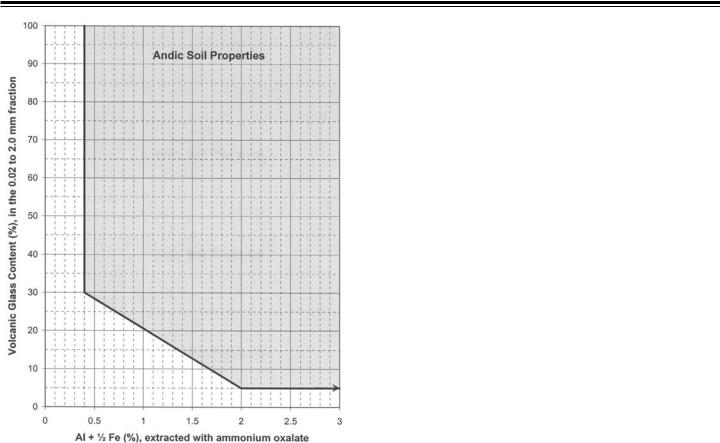
Figure 1.—Soils that are plotted in the shaded area meet the andic soil properties criteria c, d, and e under item 3 of the required characteristics. To qualify as soils with andic properties, the soils
must also meet the listed requirements for organic-carbon content, phosphate retention, and particle-size distribution.
glass and glass-coated minerals rich in silica is termed volcanic glass in this taxonomy. These minerals are relatively soluble and undergo fairly rapid transformation when the soils are moist. Andic soil properties represent a stage in transition where weathering and transformation of primary alumino-silicates
(e.g., volcanic glass) have proceeded only to the point of the formation of short-range-order materials, such as allophane, imogolite, and ferrihydrite, or of metal-humus complexes. The concept of andic soil properties includes moderately weathered soil material, rich in short-range-order materials or metalhumus complexes, or both, with or without volcanic glass
(required characteristic 2) and weakly weathered soil, less rich in short-range-order materials with volcanic glass (required characteristic 3).
Relative amounts of allophane, imogolite, ferrihydrite, or metal-humus complexes in the colloidal fraction are inferred from laboratory analyses of aluminum, iron, and silica extracted by ammonium oxalate, and from phosphate retention. Soil scientists may use smeariness or pH in 1N sodium fluoride (NaF) as field indicators of andic soil properties. Volcanic glass content is the percent volcanic glass (by grain count) in
the coarse silt and sand (0.02 to 2.0 mm) fraction. Most soil materials with andic soil properties consist of mineral soil materials, but some are organic soil materials with less than 25 percent organic carbon.
Required Characteristics
Soil materials with andic soil properties must have a fineearth fraction that meets the following requirements:
1. Less than 25 percent organic carbon (by weight) and one or both of the following:
2. All of the following:
a. |
Bulk density, measured at 33 kPa water retention, of |
0.90 g/cm3 or less; and |
|
b. |
Phosphate retention of 85 percent or more; and |
c. Al plus ½ Fe content (by ammonium oxalate) equal to
2.0 percent or more; or 3. All of the following:
a. |
30 percent or more of the fine-earth fraction is 0.02 to |
2.0 mm in size; and |
|
b. |
Phosphate retention of 25 percent or more; and |
c. Al plus ½ Fe content (by ammonium oxalate) equal to
0.4 percent or more; and
d. |
Volcanic glass content of 5 percent or more; and |
e. |
[(Al plus ½ Fe content, percent) times (15.625)] + |
[volcanic glass content, percent] = 36.25 or more.
The shaded area in figure 1 illustrates criteria 3c, 3d, and 3e.
Anhydrous Conditions
Anhydrous (Gr. anydros, waterless) conditions refer to the moisture condition of soils in very cold deserts and other areas with permafrost (often dry permafrost). These soils typically have low precipitation (usually less than 50 mm
water equivalent per year) and a moisture content of less than 3 percent by weight. Anhydrous soil conditions are similar to the aridic (torric) soil moisture regimes (defined below), except that the soil temperature at 50 cm is less than 5 oC throughout the year in the soil layers with these conditions.
Required Characteristics
Soils with anhydrous conditions have a mean annual soil temperature of 0 oC or colder. The layer from 10 to 70 cm below the soil surface has a soil temperature of less than 5 oC throughout the year and this layer:
1. Includes no ice-impregnated permafrost; and
2. Is dry (water held at 1500 kPa or more) in one-half or more of the soil for one-half or more of the time the layer has a soil temperature above 0 oC; or

Horizons and Characteristics Diagnostic for the Higher Categories |
19 |
3. Has a rupture-resistance class of loose to slightly hard throughout when the soil temperature is 0 oC or colder, except where a cemented pedogenic horizon occurs.
Coefficient of Linear Extensibility (COLE)
The coefficient of linear extensibility (COLE) is the ratio of the difference between the moist length and dry length of a clod to its dry length. It is (Lm - Ld)/Ld, where Lm is the length at 33 kPa tension and Ld is the length when dry. COLE can be calculated from the differences in bulk density of the clod when moist and when dry.An estimate of COLE can be calculated in the field by measuring the distance between two pins in a clod of undisturbed soil at field capacity and again after the clod has dried. COLE does not apply if the shrinkage is irreversible.
Durinodes
Durinodes (L. durus, hard, and nodus, knot) are weakly cemented to indurated nodules or concretions with a diameter of 1 cm or more. The cement is SiO2, presumably opal and microcrystalline forms of silica. Durinodes break down in hot concentrated KOH after treatment with HCl to remove
carbonates but do not break down with concentrated HCl alone. Dry durinodes do not slake appreciably in water, but prolonged soaking can result in spalling of very thin platelets. Durinodes are firm or firmer and brittle when wet, both before and after treatment with acid. Some durinodes are roughly concentric when viewed in cross section, and concentric stringers of opal are visible under a hand lens.
Fragic Soil Properties
Fragic soil properties are the essential properties of a fragipan. They have neither the layer thickness nor volume requirements for the fragipan. Fragic soil properties are in subsurface horizons, although they can be at or near the surface in truncated soils. Aggregates with fragic soil properties have a firm or firmer rupture-resistance class and a brittle manner of failure when soil water is at or near field capacity.Air-dry fragments of the natural fabric, 5 to 10 cm in diameter, slake when they are submerged in water. Aggregates with fragic soil
properties show evidence of pedogenesis, including one or more of the following: oriented clay within the matrix or on faces of peds, redoximorphic features within the matrix or on faces of peds, strong or moderate soil structure, and coatings of albic materials or uncoated silt and sand grains on faces of peds or in seams. Peds with these properties are considered to have fragic soil properties regardless of whether or not the density and brittleness are pedogenic.
Soil aggregates with fragic soil properties must:
1. Show evidence of pedogenesis within the aggregates or, at a minimum, on the faces of the aggregates; and
2. Slake when air-dry fragments of the natural fabric, 5 to 10 cm in diameter, are submerged in water; and
3. Have a firm or firmer rupture-resistance class and a brittle manner of failure when soil water is at or near field capacity; and
4. Restrict the entry of roots into the matrix when soil water is at or near field capacity.
Free Carbonates
The term “free carbonates” is used in the definitions of a number of taxa, is used as a criterion for the isotic mineralogy class, and is mentioned in the discussion of chemical analyses in the appendix. It refers to soil carbonates that are uncoated or unbound and that effervesce visibly or audibly when treated with cold, dilute HCl. The term “free carbonates” is nearly synonymous with the term “calcareous.” Soils that have free carbonates generally have calcium carbonate as a common mineral, although sodium and magnesium carbonates are also included in this concept. Soils or horizons with free carbonates may have inherited the carbonate compounds from parent materials without any translocation or transformation processes acting on them. There is no implication of pedogenesis in the concept of free carbonates, as there is in identifiable secondary carbonates (defined below), although most forms of secondary carbonates are freely effervescent.
Identifiable Secondary Carbonates
The term “identifiable secondary carbonates” is used in the definitions of a number of taxa. It refers to translocated
authigenic calcium carbonate that has been precipitated in place from the soil solution rather than inherited from a soil parent material, such as calcareous loess or limestone residuum.
Identifiable secondary carbonates either may disrupt the soil structure or fabric, forming masses, nodules, concretions, or spheroidal aggregates (white eyes) that are soft and powdery when dry, or may be present as coatings in pores, on structural faces, or on the undersides of rock or pararock fragments. If present as coatings, the secondary carbonates cover a significant part of the surfaces. Commonly, they coat all of the surfaces
to a thickness of 1 mm or more. If little calcium carbonate is present in the soil, however, the surfaces may be only partially coated. The coatings must be thick enough to be visible when moist. Some horizons are entirely engulfed by carbonates. The color of these horizons is largely determined by the carbonates. The carbonates in these horizons are within the concept of identifiable secondary carbonates.
The filaments commonly seen in a dry calcareous horizon are within the meaning of identifiable secondary carbonates if the filaments are thick enough to be visible when the soil is moist.
Filaments commonly branch on structural faces.
Interfingering of Albic Materials
The term “interfingering of albic materials” refers to albic materials that penetrate 5 cm or more into an underlying
D
I
A

20 |
Keys to Soil Taxonomy |
argillic, kandic, or natric horizon along vertical and, to a lesser degree, horizontal faces of peds. There need not be a continuous overlying albic horizon. The albic materials constitute less
than 15 percent of the layer that they penetrate, but they form continuous skeletans (ped coatings of clean silt or sand defined by Brewer, 1976) 1 mm or more thick on the vertical faces of peds, which means a total width of 2 mm or more between abutting peds. Because quartz is such a common constituent of silt and sand, these skeletans are usually light gray when moist
and nearly white when dry, but their color is determined in large part by the color of the sand or silt fraction.
Required Characteristics
Interfingering of albic materials is recognized if albic materials:
1. Penetrate 5 cm or more into an underlying argillic, kandic, or natric horizon; and
2. Are 2 mm or more thick between vertical faces of abutting peds; and
3. Constitute less than 15 percent (by volume) of the layer that they penetrate.
Lamellae
Lamellae (lamella, if singular) are illuvial horizons less than 7.5 cm thick. Each lamella contains an accumulation of oriented silicate clay on or bridging sand and silt grains (and rock fragments if any are present). A lamella has more silicate clay than the overlying eluvial horizon.
Required Characteristics
Alamella is an illuvial horizon less than 7.5 cm thick formed in unconsolidated regolith more than 50 cm thick. Each lamella contains an accumulation of oriented silicate clay on or bridging the sand and silt grains (and rock fragments if any are present).
Each lamella is required to have more silicate clay than the overlying eluvial horizon.
Lamellae occur in a vertical series of two or more, and each lamella must have an overlying eluvial horizon. (An eluvial horizon is not required above the uppermost lamella if the soil is truncated.)
Lamellae may meet the requirements for either a cambic or an argillic horizon. A combination of two or more lamellae 15 cm or more thick is a cambic horizon if the texture class is very fine sand, loamy very fine sand, or finer.Acombination of two or more lamellae meets the requirements for an argillic horizon if there is 15 cm or more cumulative thickness of lamellae that are 0.5 cm or more thick and that have a clay content of either:
1. 3 percent or more (absolute) higher than in the overlying eluvial horizon (e.g., 13 percent versus 10 percent) if any part of the eluvial horizon has less than 15 percent clay in the fine-earth fraction; or
2. 20 percent or more (relative) higher than in the overlying eluvial horizon (e.g., 24 percent versus 20 percent) if all parts of the eluvial horizon have more than 15 percent clay in the fineearth fraction.
Linear Extensibility (LE)
Linear extensibility (LE) helps to predict the potential of a soil to shrink and swell. The LE of a soil layer is the product of the thickness, in cm, multiplied by the COLE of the layer in question. The LE of a soil is the sum of these products for all soil horizons. Linear extensibility is a criterion for most
Vertic subgroups in this taxonomy and is calculated as summed products from the mineral soil surface to a depth of 100 cm or to a root-limiting layer (defined in chapter 17).
Lithologic Discontinuities
Lithologic discontinuities are significant changes in particlesize distribution or mineralogy that represent differences in lithology within a soil. A lithologic discontinuity can also denote an age difference. For information on using horizon designations for lithologic discontinuities, see the Soil Survey Manual (Soil Survey Division Staff, 1993) and chapter 18 of this document.
Not everyone agrees on the degree of change required for a lithologic discontinuity. No attempt is made to quantify lithologic discontinuities. The discussion below is meant to serve as a guideline.
Several lines of field evidence can be used to evaluate lithologic discontinuities. In addition to mineralogical and textural differences that may require laboratory studies, certain observations can be made in the field. These include but are not limited to the following:
1. Abrupt textural contacts.—An abrupt change in particle-size distribution, which is not solely a change in clay content resulting from pedogenesis, can often be observed.
2. Contrasting sand sizes.—Significant changes in sand size can be detected. For example, if material containing mostly medium sand or finer sand abruptly overlies material containing mostly coarse sand and very coarse sand, one can assume that there are two different materials. Although the materials may be of the same mineralogy, the contrasting sand sizes result from differences in energy at the time of deposition by water and/or wind.
3. Bedrock lithology vs. rock fragment lithology in the soil.—If a soil with rock fragments overlies a lithic contact, one would expect the rock fragments to have a lithology similar to that of the material below the lithic contact. If many of the rock fragments do not have the same lithology as the underlying bedrock, the soil is not derived completely from the underlying bedrock.
4. Stone lines.—The occurrence of a horizontal line of rock fragments in the vertical sequence of a soil indicates that the soil may have developed in more than one kind of parent