

9432_cons_en
.pdfChapter 7. Approach control |
7-5 |
|
|
STEPHENVILLE APPROACH
G-DCAB
G-DCAB STEPHENVILLE
APPROACH
G-DCAB ESTIMATING STEPHENVILLE
NDB AT 18 FL 70
G-AB CLEARED NDB APPROACH RUNWAY 24
DESCEND TO 3 000 FEET QNH 1011 TRANSITION LEVEL 50,
NO DELAY EXPECTED
CLEARED NDB APPROACH RUNWAY 24 LEAVING FL 70
DESCENDING TO 3 000 FEET QNH 1011 TRANSITION LEVEL 50,
G-AB
G-AB OVER STEPHENVILLE NDB 3 000 FEET FIELD
IN SIGHT, REQUEST VISUAL APPROACH
G-AB CLEARED VISUAL APPROACH RUNWAY 24 NUMBER 1
CONTACT TOWER 118.7
CLEARED VISUAL APPROACH RUNWAY 24, 118.7 G-AB
7.3.3 Normally a holding procedure should be published. However, when the pilot requires a detailed description of the holding procedure based on a facility, the following phraseology should be used:
FASTAIR 345 HOLD AT
NORTH CROSS FL 100
FASTAIR 345 REQUEST HOLDING
INSTRUCTIONS
FASTAIR 345 HOLD AT NORTH CROSS
NDB FL 100 INBOUND TRACK 250 DEGREES
LEFT HAND PATTERN OUTBOUND TIME 1 MINUTE
– – – – – – – – –
FASTAIR 345 REQUEST HOLDING PROCEDURE
FASTAIR 345 HOLD ON THE 265 RADIAL OF
MARLO VOR BETWEEN 25 MILES AND 30 MILES
DME FL 100 INBOUND TRACK 085 RIGHT HAND
PATTERN EXPECTED APPROACH TIME 1032
7-6 |
Manual of Radiotelephony |
|
|
Note.— It may assist controllers to know that the above information should be passed in the following order:
1)Fix
2)Level
3)Inbound track
4)Right or left turns
5)Time of leg (if necessary)
7.4VFR ARRIVALS
Depending on the procedures in use, the pilot of an arriving VFR flight may be required to establish contact with the approach control unit and request instructions before entering its area of jurisdiction. Where there is an ATIS broadcast, the pilot should acknowledge if it has been received; where no ATIS broadcast is provided, the approach controller will pass the aerodrome data.
STEPHENVILLE APPROACH
G-ABCD
G-ABCD STEPHENVILLE
APPROACH
G-ABCD C172 VFR FROM WALDEN TO
STEPHENVILLE 2 500 FEET CONTROL ZONE BOUNDARY 52
STEPHENVILLE 02 INFORMATION GOLF
G-CD CLEARED TO STEPHENVILLE VFR QNH 1012
TRAFFIC SOUTHBOUND CHEROKEE 2 000 FEET VFR
ESTIMATING CONTROL ZONE BOUNDARY 53
CLEARED TO STEPHENVILLE VFR
QNH 1012 TRAFFIC IN SIGHT G-CD
G-CD REPORT AERODROME IN SIGHT
WILCO G-CD
G-CD AERODROME IN SIGHT
G-CD CONTACT TOWER 118.7
118.7 G-CD
Note.— The phraseology for joining the aerodrome traffic circuit is detailed in Chapter 4.
Chapter 7. Approach control |
7-7 |
|
|
7.5VECTORS TO FINAL APPROACH
7.5.1Vectors are given to arriving flights to position them onto a pilot-interpreted final approach aid, or to a point from which a radar-assisted approach can be made, or to a point from which a visual approach can be made. In the following example, an identified aircraft inbound to Georgetown is given radar vectors to the ILS.
GEORGETOWN ARRIVAL FASTAIR
345 HEAVY FL 60 APPROACHING NORTH CROSS INFORMATION GOLF
FASTAIR 345 RADAR
CONTACT VECTORING FOR
ILS APPROACH RUNWAY 27
QNH 1008
ILS APPROACH RUNWAY 27 QNH 1008 FASTAIR 345
FASTAIR 345 LEAVE NORTH CROSS NDB HEADING 110
LEAVING NORTH CROSS NDB HEADING 110 FASTAIR 345
FASTAIR 345 REPORT SPEED
FASTAIR 345 SPEED 250 KNOTS
FASTAIR 345 REDUCE TO MINIMUM CLEAN SPEED
REDUCING TO 210 KNOTS FASTAIR 345
FASTAIR 345 DESCEND TO 2 500 FEET QNH 1008,
TRANSITION LEVEL 50 NUMBER 4 IN TRAFFIC
LEAVING FL 60 DESCENDING TO 2 500 FEET QNH 1008,
TRANSITION LEVEL 50
FASTAIR 345
FASTAIR 345 POSITION 10 MILES NORTH EAST OF
GEORGETOWN
ROGER FASTAIR 345
FASTAIR 345 TURN RIGHT HEADING 180
FOR BASE
LEG
RIGHT HEADING 180 FASTAIR 345
7-8 |
Manual of Radiotelephony |
|
|
FASTAIR 345 12 MILES FROM TOUCHDOWN REDUCE
TO MINIMUM APPROACH SPEED, TURN RIGHT
HEADING 230 CLEARED FOR ILS APPROACH
RUNWAY 27 REPORT ESTABLISHED
REDUCING TO MINIMUM APPROACH SPEED RIGHT HEADING 230 CLEARED FOR ILS APPROACH
RUNWAY 27 WILCO FASTAIR 345
FASTAIR 345 ESTABLISHED
FASTAIR 345 NO ATC SPEED RESTRICTIONS,
CONTACT TOWER 118.9
118.9 FASTAIR 345
Note.— The radar controller should advise the aircraft of its position at least once prior to turning onto final approach.
7.5.2 In the example above, the approach speed of the aircraft is reduced in order to ensure adequate separation from the preceding aircraft. Speed adjustment can often reduce the need for radar vectoring in establishing an approach sequence. Where speed adjustment would be insufficient to ensure correct spacing, it may be necessary to issue additional vectors.
FASTAIR 345 MAKE A THREE
SIXTY TURN LEFT
FOR DELAY
THREE SIXTY TURN LEFT
FASTAIR 345
or
FASTAIR 345 CONTINUE PRESENT HEADING
TAKING YOU THROUGH THE LOCALIZER FOR SPACING
CONTINUING PRESENT HEADING FASTAIR 345
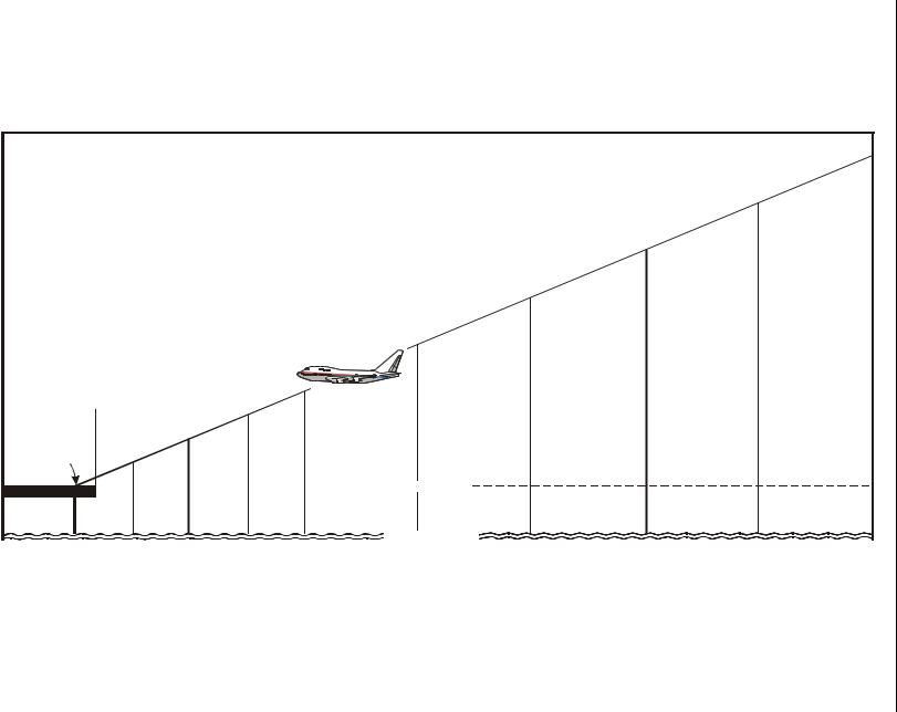
7.6SURVEILLANCE RADAR APPROACH
On a surveillance radar approach (SRA), the pilot is given distances from touchdown, advisory altitude or height information and azimuth instructions so as to be able to carry out an approach. In the following example, it is presupposed that the aircraft has been vectored to intercept the final approach track at 8 NM from touchdown at 2 200 ft QNH and that the touchdown elevation is 300 ft. Advisory altitudes relate to a 3 degree glide path.

Chapter 7. Approach control |
7-9 |
|
|
WICKEN APPROACH
FASTAIR 345 HEAVY
FASTAIR 345 WICKEN APPROACH THIS WILL BE A SURVEILLANCE RADAR APPROACH RUNWAY 27 TERMINATING AT 1 MILE FROM TOUCHDOWN OBSTACLE CLEARANCE ALTITUDE 600 FEET MAINTAIN 2 200 FEET CHECK YOUR MINIMA
MAINTAINING 2 200 FEET RUNWAY 27 FASTAIR 345
FASTAIR 345 TURN RIGHT HEADING 275 FOR FINAL REPORT RUNWAY IN SIGHT
(see Note 3)
RIGHT HEADING 275 FASTAIR 345
FASTAIR 345 6 MILES FROM
TOUCHDOWN COMMENCE DESCENT NOW TO
MAINTAIN A 3 DEGREE GLIDE PATH
FASTAIR 345 DESCENDING
FASTAIR 345 CHECK GEAR DOWN AND LOCKED
FASTAIR 345
FASTAIR 345 5½ MILES FROM TOUCHDOWN
ALTITUDE SHOULD BE 2 000 FEET
FASTAIR 345
FASTAIR 345 GOING RIGHT OF TRACK TURN LEFT
FIVE DEGREES HEADING 270
HEADING 270 FASTAIR 345
FASTAIR 345 5 MILES FROM TOUCHDOWN
ALTITUDE SHOULD BE 1 900 FEET
FASTAIR 345
FASTAIR 345 CLOSING SLOWLY FROM THE RIGHT 4½ MILES FROM TOUCHDOWN ALTITUDE SHOULD BE 1 700 FEET
FASTAIR 345

7-10 |
Manual of Radiotelephony |
|
|
FASTAIR 345 RUNWAY 27 CLEARED TO LAND WIND CALM
RUNWAY 27 CLEARED TO LAND FASTAIR 345
FASTAIR 345 4 MILES FROM TOUCHDOWN
ALTITUDE SHOULD BE 1 600 FEET DO NOT
ACKNOWLEDGE FURTHER TRANSMISSIONS
FASTAIR 345 3½ MILES FROM TOUCHDOWN
ALTITUDE SHOULD BE 1 400 FEET
FASTAIR 345 ON TRACK TURN RIGHT THREE DEGREES
HEADING 272 3 MILES FROM TOUCHDOWN
ALTITUDE SHOULD BE 1 300 FEET
FASTAIR 345 2½ MILES FROM TOUCHDOWN
ALTITUDE SHOULD BE 1 100 FEET
FASTAIR 345 2 MILES FROM TOUCHDOWN
ALTITUDE SHOULD BE 900 FEET
FASTAIR 345 ON TRACK HEADING IS GOOD
1½ MILES FROM TOUCHDOWN ALTITUDE SHOULD BE 800 FEET
FASTAIR 345 RUNWAY IN SIGHT
FASTAIR 345 ON TRACK 1 MILE FROM TOUCHDOWN, APPROACH COMPLETED AFTER LANDING CONTACT TOWER ON 118.7
Note 1.— Where an SRA procedure terminates at 2 miles from touchdown, the distance from touchdown and advisory altitude checks are normally passed at 1 mile intervals. Where the SRA terminates at less than 2 miles from touchdown, such checks are given each half mile.
Note 2.— Aircraft replies are expected to all transmissions. However, when the SRA terminates at less than 2 miles from touchdown, the controller’s transmissions should not be interrupted for intervals of more than 5 seconds once the aircraft is within 4 miles from touchdown and aircraft replies are then not expected.
Note 3.— When the pilot reports runway in sight during an SRA and there is reasonable assurance that a landing will be effected, the SRA may be terminated.
Note 4.— An example of pre-computed levels for a 3 degree glide path, where the elevation of the touchdown point is 300 ft AMSL, appears in Figure 2.
|
.2 Figure |
is point touchdown the of elevation the where |
levels of Example approach: radar Surveillance |
AMSL ft 300 |
degree 3 a for |
|
path, glide |
|
|
|
|
|
|
|
|
|
|
|
|
) |
|
|
|
|
|
|
|
|
|
|
|
|
H |
|
|
|
|
|
|
|
|
|
|
|
|
N |
|
|
|
|
|
|
|
|
|
|
|
|
(Q |
|
|
|
|
|
|
|
|
|
|
|
s |
|
|
|
|
||
|
|
|
|
|
e |
|
|
|
|
) |
|||
|
|
|
|
d |
|
|
|
|
|
|
|||
|
|
|
u |
|
|
|
|
|
|
|
E |
||
|
|
it |
|
|
|
|
|
|
|
F |
|
||
|
lt |
|
|
|
|
|
|
|
|
|
|||
|
A |
|
|
|
|
|
|
|
|
(Q |
|
|
|
|
|
|
|
|
|
|
|
ts |
|
|
|
||
|
|
|
|
|
|
h |
|
|
|
|
|||
670 m/2 200 ft |
|
|
|
ig |
|
|
|
|
|
|
|||
|
|
e |
|
|
|
|
|
|
|
|
|||
H |
|
|
|
|
|
|
|
|
|
|
|||
|
580 m/1 900 ft |
|
|
|
|||||||||
570 m/1 900 ft
480 m/1 600 ft
|
|
|
|
|
470 m/1 600 ft |
|
|
|
|
|
|
|
|
|
380 m/1 300 ft |
|
|
|
|
|
|
|
380 m/1 300 ft |
|
|
|
|
|
|
|
|
290 m/1 000 ft |
|
|
|
Reference datum at 15 m |
|
280 m/900 ft |
|
|
|
|
||
(50 ft) above threshold |
|
240 m/800 ft |
190 m/600 ft |
|
|
|
||
|
|
|
|
|
|
|
||
|
190 m/600 ft |
140 m/500 ft |
|
|
|
|
||
|
|
|
|
|
|
|
||
Touchdown |
|
100 m/300 ft |
|
|
|
|
|
|
|
|
|
|
|
|
|
|
|
91 m/300 ft |
|
|
|
|
TOUCHDOWN LEVEL |
|
|
|
|
|
|
|
|
|
|
|
|
0 |
|
|
|
|
MEAN SEA LEVEL |
|
|
|
1/2 |
1 |
1 1/2 |
2 |
3 |
4 |
5 |
6 |
|
|
|
|
|
DISTANCE FROM TOUCHDOWN IN NAUTICAL MILES |
|
|
||
control Approach .7 Chapter
11-7
7-12 |
Manual of Radiotelephony |
|
|
7.7PRECISION RADAR APPROACH
7.7.1In a precision radar approach, the controller, in addition to providing heading instructions during the continuous talkdown, provides information on altitudes relative to the glide slope, together with instructions on corrective action in the event that the aircraft is too high or too low. In the following example, based on a 3 degree glide slope to runway 27 at Georgetown, it is presupposed that the aircraft has been radar vectored into precision approach radar (PAR) coverage and has been identified to the PAR controller by radar transfer.
FASTAIR 345 GEORGETOWN
PRECISION REPORT HEADING
AND ALTITUDE
HEADING 240 AT 3 000 FEET
FASTAIR 345
FASTAIR 345 THIS WILL BE A PRECISION RADAR
APPROACH RUNWAY 27, OBSTACLE CLEARANCE
ALTITUDE 400 FEET
POSITION 6 MILES EAST OF GEORGETOWN TURN RIGHT
HEADING 260 DESCEND TO 2 500 FEET QNH 1014
PRECISION APPROACH RUNWAY 27, HEADING 260 DESCENDING TO
2 500 FEET QNH 1014 FASTAIR 345
FASTAIR 345 CLOSING FROM THE RIGHT TURN
RIGHT HEADING 270
RIGHT HEADING 270 FASTAIR 345
FASTAIR 345 ON TRACK APPROACHING GLIDE PATH
HEADING
IS GOOD
FASTAIR 345
FASTAIR 345 REPORT RUNWAY IN SIGHT
FASTAIR 345
FASTAIR 345 DO NOT ACKNOWLEDGE FURTHER TRANSMISSIONS, ON TRACK APPROACHING GLIDE PATH . . . CHECK YOUR MINIMA . . . COMMENCE DESCENT NOW AT 500 FEET PER MINUTE . . . I SAY AGAIN 500 FEET PER MINUTE . . . CHECK
GEAR DOWN AND LOCKED . . . ON GLIDE PATH 5 MILES FROM TOUCHDOWN . . . SLIGHTLY LEFT OF TRACK, TURN RIGHT 5 DEGREES NEW HEADING 275 I SAY AGAIN 275 . . .

Chapter 7. Approach control |
7-13 |
||
|
|
|
|
|
4 MILES FROM TOUCHDOWN SLIGHTLY BELOW |
|
|
|
|
|
|
|
GLIDE PATH . . . 100 FEET |
|
|
|
TOO LOW ADJUST RATE OF DESCENT . . . STILL 50 FEET |
|
|
|
TOO LOW, TURN LEFT 3 DEGREES HEADING 272 ON |
|
|
|
TRACK 3 MILES FROM TOUCHDOWN . . . COMING |
|
|
|
BACK TO THE GLIDE PATH . . . ON GLIDE PATH 2½ MILES |
|
|
|
FROM TOUCHDOWN RESUME NORMAL RATE OF |
|
|
|
DESCENT . . . FASTAIR 345 CLEARED TO LAND . . . ON |
|
|
|
GLIDE PATH . . . HEADING 272 IS GOOD SLIGHTLY ABOVE |
|
|
|
GLIDE PATH . . . 2 MILES FROM TOUCHDOWN . . . COMING |
|
|
|
BACK TO THE GLIDE PATH . . . ON GLIDE PATH 1¾ MILES |
|
|
|
FROM TOUCHDOWN . . . TURN LEFT 2 DEGREES NEW |
|
|
|
HEADING 270 . . . 1½ MILES FROM TOUCHDOWN |
|
|
|
. . . ON GLIDE PATH 1¼ MILES FROM TOUCHDOWN RATE |
|
|
|
OF DESCENT IS GOOD ON GLIDE PATH 1 MILE FROM |
FASTAIR 345 RUNWAY IN SIGHT |
|
|
TOUCHDOWN |
|
|
|
. . . ¾ OF A MILE FROM TOUCHDOWN ON GLIDE |
|
|
|
PATH . . . ½ MILE FROM TOUCHDOWN ON GLIDE |
|
|
|
PATH . . . |
|
|
|
¼ MILE FROM TOUCHDOWN APPROACH COMPLETED |
|
|
|
AFTER LANDING CONTACT TOWER ON 118.7 |
|
|
|
|
|
|
7.7.2 When the radar returns on the elevation element of the PAR indicating that the pilot may be making a missed approach, the radar controller shall, when there is sufficient time to obtain a reply from the pilot, pass the aircraft’s height above the glide path and ask the pilot if a missed approach is intended.
. . . SLIGHTLY ABOVE GLIDE PATH 3 MILES FROM TOUCHDOWN . . . STILL ABOVE GLIDE PATH 2½ MILES FROM TOUCHDOWN — GOING FURTHER ABOVE GLIDE PATH 2 MILES FROM TOUCHDOWN ARE YOU GOING AROUND
7.7.3 In similar circumstances, but when there is not sufficient time to obtain a reply from the pilot, the controller should continue the precision approach emphasizing the aircraft’s displacement. If it becomes apparent that the pilot is making a missed approach, either before or after the normal termination point, the radar controller shall pass missed approach instructions.
___________________
Chapter 8
AREA CONTROL
8.1AREA CONTROL UNITS
8.1.1Area control units vary in size from simple one-person procedural units to large sophisticated centres which may contain departure, arrival and terminal control sections equipped with radar. RTF phraseology given below would be suitable for any of the above air traffic services.
8.1.2Much of the phraseology used in area control is of a general nature and is detailed in Chapter 3. However, many instructions used in area control (particularly where radar is not available) are related to specific conditions in order to maintain aircraft separation.
8.1.3The following examples provide a cross-section of phraseology used in area control. They may be varied, or added to, by combining their component parts according to the requirements of the prevailing traffic situation.
FASTAIR 345 REQUEST DESCENT
FASTAIR 345 MAINTAIN FL 350
EXPECT DESCENT
AFTER BITOR
MAINTAINING FL 350 FASTAIR 345
– – – – – – – – –
FASTAIR 345 MAINTAIN FL 350
UNTIL ADVISED
MAINTAINING FL 350 FASTAIR 345
– – – – – – – – –
FASTAIR 345 DESCEND TO FL 130 CROSS WICKEN VOR
FL 170 OR ABOVE
LEAVING FL 350 DESCENDING TO FL 130 CROSS WICKEN VOR
FL 170 OR ABOVE FASTAIR 345
– – – – – – – – –
8-1