

A Dictionary of Archaeology
.pdfAntequera Group of passage graves of the 3rd millennium BC near the town of Antequera, about 40 km north of Malaga, Spain. Some of the finest monuments of their type in Iberia, the most interesting architecturally is the Cueva de Romeral, the circular mound (90 m diam.) of which covers a dry-stone passage roofed with megaliths and two round dry-stone chambers. The larger chamber (4.5 m diam.) is connected to the smaller one, which contains a supposed ‘altar’ slab, by a short secondary passage. Both chambers have domed corbelled roofs – topped with a slab – and the tomb is thus sometimes described as a ‘THOLOS’-type construction, after the (otherwise unrelated) beehive-shaped tombs of the Aegean. Underneath the mound (c.50 m diam.) of the Cueva de la Menga a short passage leads to an exceptionally large, oval (6.5 m wide) megalithic chamber roofed with huge capstones supported by three pillars. An orthostat in the passage is decorated with anthropomorphic figures and a star-like design. The long (originally c.30 m) passage of the Cueva de la Viera, under a mound of 60 m diameter, is lined and roofed with megaliths; the passage, the chamber, and an additional space beyond the small slab-built chamber are all entered via porthole slabs.
C. de Mergelina: ‘La necrópolis tartesia de Antequera’,
Actas y memórias de la Sociedad Español de Antropología, Etnografía y Prehistoria 1 (1922), 37–90; R. Joussaume: Dolmens for the Dead, trans. A. and C. Chippendale (London, 1988), 188–94.
RJA
antiquarianism Term used to refer to the study of the ancient world before archaeology emerged as a discipline. Antiquarianism first appeared in the 15th century as a historical branch of Renaissance humanism. Perhaps the earliest writer to be specifically described as an ‘antiquario’ was the Italian epigrapher Felice Feliciano (1433–80), but there were many other European scholars in the early 15th century who were studying ‘antiquities’ (although the word ‘antiquity’ was not used in its modern sense until Andrea Fulvio’s
Antiquitates urbis of 1527).
Most of the early antiquaries were more historians than proto-archaeologists or prehistorians, although the archetypal antiquary was increasingly distinguished from the historian by his supposed obsession with ancient objects, particularly in the form of the so-called ‘cabinet of curiosities’ (typically consisting of coins, medals and flint arrowheads); these were often disparaged by contemporaries in comparison with collections of sculpture or paintings. The overriding link
ANURADHAPURA 65
between the antiquary and the early archaeologist was therefore the concern with physical antiquities as opposed to ancient texts. The key difference is that antiquaries tended to be interested in antiquities alone rather than their archaeological and cultural contexts.
The best-known of the 17th-century antiquaries was John Aubrey (1626–97), whose studies of Stonehenge and Avebury, published in his Monumenta Britannica (c.1675), led him to identify them as the temples of the druids (see Hunter 1975). However, the scholar who probably brought the world of antiquarianism closest to the brink of early archaeology was William Stukeley (1687–1785), whose theodolite surveys and perspective drawings of STONEHENGE and AVEBURY, as well as his recognition of prehistoric field systems, lead Piggott to describe him as a ‘field archaeologist’.
T.D. Kendrick: British Antiquity (London, 1950); M. Hunter: John Aubrey and the realm of learning (London, 1975); S. Piggott: William Stukeley (London, 1985); J.M. Levine: Humanism and history (Cornell, 1987); S. Piggott:
Ancient Britons and the antiquarian imagination: ideas from the Renaissance to the Regency (London, 1989); B.G. Trigger: A history of archaeological thought (Cambridge, 1989), 27–72.
IS
Antrea Find-site of early Mesolithic objects near the hamlet of Antrea-Korpilahti, 15 km east of Viborg. The site is now in Russia, about 20 km southeast of the Russo-Finish border, and it was first reported by Pälsi in 1920. The finds included a fishing net, which consisted of double-threaded cord, made from the bast of willow bark, with 18 oblong pine-bark floats and sink stones. The stone implements included adzes and a chisel with its working edge hollowed by polishing to a gouge-like form. Among the bone and antler implements was a knife handle made from a pointed piece of elk shin-bone; a hollow chisel made from a tubular bone; a short stout point; a knife-like tool with traces of engraved lines. Samples of the net and the bark float presented uncalibrated dates of 9230 ± 210 BP (Hel-269) and 9310 ± 140 BP (Hel-1301).
S. Pälsi: ‘Ein steinzeitlicher Moorfund’, SMA 28 (1920), 1–19; V. Luho: ‘Die Suomusjärvi-Kultur’, SMA 66 (1967), 1–120; D.L. Clarke: The earlier Stone Age settlement in Scandinavia (Cambridge, 1975).
PD
Anuradhapura Ancient capital of Sri Lanka (c.AD 200–1000), located on the Aruvi river, 170 km northeast of Colombo. The walled core (citadel area) of the city and its surrounding Buddhist monasteries extended over an area of about
66 ANURADHAPURA
40 sq. km. Architectural remains include palaces, stupas and a rock-cut temple.
J. Uduwara: Illustrated guide to the Museum of Archaeology, Anuradhapura (Anuradhapura, 1962); S.U. Deraniyagala: ‘The citadel of Anuradhapura 1969: excavations in the Gedige area’, Ancient Ceylon 2 (1972), 48–169; C. Wikramgange: Abhayagiri Vihara Project, Anuradhapura: first report of excavations (Colombo, 1984).
CS
A
B
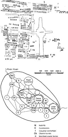
Figure 4 An-yang (A) Plan of typical royal burials (M1129, M1400 and M1422) at Hsi-pei-kang, An-yang, with long ramps leading down to the tombs, and numerous single and multiple burials arranged alongside; (B) structural model of the An-yang urban network during the Shang period, based on archaeological foci. Source: Chang Kwang-chih: Shang China (New Haven and London, 1980), p. 130.
An-yang (Anyang: ‘ruins of Yin’) Area of settlement and funerary sites in the province of Ho-nan, China, which was both the last capital of the SHANG dynasty (c.1400–1122 BC, see CHINA 2) and the first major region of China to be subjected to intensive modern excavation. The earliest excavations took place between 1928 and 1937, in and around the village of Hsiao-t’un and in the major ‘royal’ tomb area at Hsi-pei-kang (also known by the names of nearby villages such as Wu-kuan-ts’un-pei-ti and Hou- chia-chuang). The work was directed by Li Chi and scholars of the Academia Sinica, Peking, and included the recovery of some 17,000 inscribed ORACLE BONES and turtle plastrons from the storage pit, YH 127, during the winter of 1936–7; they were carefully lifted out of the ground as a solid mass of material, thus allowing a precise record of each fragment’s original placement to be made during the cleaning process. A similar find of some 5000 inscribed oracle bones in 1972 at the Hsiao-t’un Nan-ti site has added to the considerable volume of these invaluable primary documents (see CHINA 3).
The principal tombs at Hsi-pei-kang are mainly of a characteristic cross-shape with ramps leading from the original ground level to the floor of the tomb pit (figure 4A). The occupant (presumably royal) was laid in a wooden chamber built to a height of about 3 m together with a large quantity of grave goods of which only a small number remains because of robbery in recent and earlier times. Outside the chamber, and along the ramps, further goods were placed and sacrificial victims (human as well as animal) were interred.
Nearby in this funerary area, and possibly related to the royal tombs, are many small burials (single and multiple – some with skulls only, others with bodies only), horse-burials, pits with elephants and other animals, and chariots. Settlement sites include appreciably large foundations of many layers of rammed earth (hang-t’u) in the Hsiao-t’un Locus North sector which have been classed as ‘palace foundations’. Sufficient evidence remained to show that wooden structures comprising posts resting on stone supports, with wattle-and-daub walls, and thatched roofs had been built on these. Elsewhere the dwelling remains of the general populace consisted mainly of semi-subterranean structures of round shape which appear to have differed little from the pit-houses of the late Neolithic period. Workshop areas were evident and the various industrial activities in which much of the populace was engaged seem to have been concentrated in areas of specialized manufacturing: large quantities of stone knives were found in one sector, bone arrowheads in another, shell and jade
working remains in another. In at least two areas, a few ingots of copper and tin, hundreds of clay moulds and crucible fragments demonstrated the extent of bronze manufacturing.
Excavations have continued at the site and in its vicinity since the 1950s; finds of considerable importance have been reported, among which the Fu Hao tomb ranks supreme. The finds include numerous bronze vessels and other bronze artefacts: helmets, chariot fittings, weapons, ornaments, etc., together with stone sculptures, carved ivory and bone, jade, lacquer, sacrificial burials of chariots and horses, all illustrating many aspects of Shang culture and daily life. It has thus been possible to reconstruct from the archaeological loci and associated evidence a model of the urban network which constituted the Shang capital (figure 4B).
Cheng Te-k’un: Archaeology in China II: Shang China
(Cambridge, 1960); D.N. Keightley: Sources of Shang history: the oracle-bone inscriptions of Bronze Age China
(Berkeley, 1978); Chang Kwang-chih: Shang China (New Haven and London, 1980); D.N. Keightley, ed.: The origins of Chinese civilization (Berkeley, 1983); Chang Kwang-chih: The archaeology of ancient China, 4th edn (New Haven and London, 1986); Chang Kwang-chih, ed.:
Studies of Shang civilization (New Haven, 1986).
NB
apadana Persian term for the reception hall in the palaces of the Achaemenid rulers (c.538–331
BC), such as those at PASARGADAE, PERSEPOLIS and
SUSA. It usually consisted of a vast rectangular building with its roof supported by dozens of columns, often built on a terrace and surrounded by columned porticoes. The Persepolis apadana had porticoes on three sides and towers at each corner; its 36 stone columns were each almost 20 m in height and were surmounted by impressive capitals in the form of bulls. The architectural antecedents of the apadana are perhaps to be found in the square columned halls at pre-Achaemenid sites such as HASANLU, and perhaps even in Urartian structures, such as the palace building at ALTINTEPE.
E.F. Schmidt: Persepolis I (Chicago, 1953), 70–90; R. Ghirshman: ‘L’apadana de Suse’, IA 3 (1963), 148–60; H. Frankfort: The art and architecture of the ancient Orient, 4th edn (Harmondsworth, 1970), 351–5.
IS
Apis Rock (Nasera) Inselberg incorporating a large rock-shelter, located on the high eastern side of the Serengeti plain in northern Tanzania. Apis Rock was first investigated by Louis Leakey in 1932, who identified a sequence running through ‘Developed Levalloisian’, ‘Proto-Stillbay’ and
‘STILLBAY’ proper to ‘MAGOSIAN’ and ‘WILTON’,
AQUATIC CIVILIZATION (OR ‘AQUALITHIC’) 67
the last being microlithic (Leakey 1936). The site was more thoroughly excavated by Michael Mehlman in 1975–6; his excavation of nine metres of deposits yielded vast quantities of lithic artefacts and animal bones, as well as pottery in the upper layers, thus providing confirmation of a long (if punctuated) sequence encompassing much of what is informally called the African Middle and Late Stone Age, and spanning the Upper Pleistocene and Holocene. Much of Leakey’s nomenclature – together with the theories concerning the evolution of cultures to which it is related – is now redundant; and some of the ‘intermediate’ categories, such as ‘Magosian’, may result from the mixing of deposits (as at MAGOSI itself).
L.S.B. Leakey: Stone Age Africa (Oxford, 1936), 59–67; M.J. Mehlman: ‘Excavations at Nasera Rock’, Azania 12 (1977), 111–18.
JS
Apollo 11 Cave Large cave-site in the Huns Mountains, south-west Namibia, which presents evidence for some of the earliest art in Africa. Four distinct levels of MSA (Middle Stone Age) assemblages include one showing affinities with the
industry, radiocarbon-dated to uncal >48,000 BP, and including worked ostrich eggshell and a pebble with faint traces of red paint. Above the MSA (Middle Stone Age) level there is an early LSA (Later Stone Age) level (uncal 19,760–12,510 BP) which may be a local (and early) expression of the ALBANY INDUSTRY, with ostrich eggshell beads, bone beads, bone tools and ostrich eggshell containers. Later levels contain typical Holocene microlithic assemblages (WILTON INDUSTRY) with an early commencing date of uncal 10,420 BP. The cave is most notable for a group of seven painted tablets of stone recovered as a group from an horizon dating to between uncal 25,500 and 27,500 BP, associated with MSA artefacts. The paintings include an animal thought to be a feline, but with human hind legs, suggesting a direct link with therianthropic paintings of Holocene age.
E. Wendt: ‘“Art Mobilier” from Apollo 11 Cave, South West Africa: Africa’s oldest dated works of art’, SAAB, 31 (1976), 5–11.
RI
Aqar Quf see KASSITES
Aquatic civilization (or ‘aqualithic’) Term coined by John Sutton to describe ‘communities whose livelihood and outlook on life revolved around lakes and rivers’. The aqualithic sites occupied a belt or arc in ‘Middle Africa’ (much of it now
68 AQUATIC CIVILIZATION (OR ‘AQUALITHIC’)
very dry) from Senegal in the west to Kenya in the east, in the period of 10,000–4000 BP. The culture was characterized archaeologically by bone harpoons and by independently invented pottery decorated with wavy and dotted wavy line motifs, of the type first recognized by A.J. Arkell at Khartoum (see EARLY KHARTOUM). Created by a Negroid population probably bearing some relation to the present-day speakers of J.H. Greenberg’s Nilo–Saharan language family, it was a ‘nonNeolithic’ culture, i.e. not associated with either agriculture or domestication, but with a potterybased ‘new gastronomy’ constituting a ‘soup, porridge, and fish-stew revolution’. According to Sutton, the success of the aquatic lifestyle may have hampered the spread of the ‘Neolithic’ in Africa, but nonetheless under its impact the aquatic cultural complex began to break up from around 7000 BP onwards. What followed were no more than late ‘regional revivals’ such as that characterized by KANSYORE ware in Kenya. ‘In the long run the aquatic way of life was unable to compete with the food-producing one’.
Subsequent modifications to, or criticisms of, Sutton’s model relate to its chronology, archaeological content and philosophical basis: (1) A.B. Smith points out that, following the appearance of domestic cattle, sheep and/or goats in the Sahara at about 7000 BP, the region was dominated by pastoralists, and it is difficult to be certain that these were the same people as the preceding lake dwellers. Kansyore ware in Kenya (if indeed it can be connected to that in the rest of the area) also turns out not to be so late after all, according to Peter Robertshaw. Hence Sutton’s ‘lacustrine tradition’ may be confined to the early Holocene. (2) The cultural unity of the area, which is supposed to belong to the Neolithic of Sudanese Tradition, has been much exaggerated, according to T.R. Hays. There may have been a Khartoum ‘horizon-style’ in the pottery, but otherwise there is little to link the disparate settlements of the Sahara in the early Holocene. (3) B.W. Andah takes issue with the ‘non-Neolithic’ emphasis of Sutton’s work, since he believes it distracts attention from the possibilities and processes of indigenous African development of agriculture, and in his view tends to portray the early Holocene inhabitants of the area as mere passive reactors to their environment.
J.E.G. Sutton: ‘The aquatic civilization of Middle Africa’, JAH 15 (1974), 527–46; T.R. Hays: ‘An examination of the Sudanese Neolithic’, Proceedings of the Panafrican Congress of Prehistory and Quaternary Studies VIIth session Addis Ababa 1971, ed. Abebe Berhanou, J. Chavaillon and J.E.G. Sutton (Addis Ababa, 1976), 85–92; J.E.G. Sutton:
‘The African aqualithic’ Antiquity, 51 (1977), 25–34; A.B. Smith: ‘The Neolithic tradition in the Sahara’, The Sahara and the Nile, ed. M.A.J. Williams and H. Faure (Rotterdam, 1980), 451–65; B.W. Andah: ‘Early food producing societies and antecedents in Middle Africa’, WAJA 17 (1987), 129–70; P. Robertshaw: ‘Gogo Falls, excavations at a complex archaeological site east of Lake Victoria’, Azania 26 (1991) 63–195.
PA-J
Arabia, pre-Islamic The pre-Islamic archaeological remains of the Arabian peninsula are still poorly known, owing to a relative dearth of excavation in Yemen and Saudi Arabia, although a great deal of evidence is beginning to emerge concerning the pre-Islamic Gulf region. There were earlier European explorers in the region, such as Johann Wild, Carsten Niebuhr and Joseph Pitts in the early 17th century, but the first to examine the antiquities in any detail were the late 19th-century travellers, Charles Doughty (who particularly studied the NABATAEAN city of Madain Salih), Charles Huber and Sir Richard Burton. The archaeological remains of Central Arabia, particularly the rock carvings (some possibly dating as early as 10,000 BC), were investigated by Harry St John Philby in the 1930s and 1950s. Most modern researches have concentrated along the Gulf coast, including excavations on the islands of BAHRAIN, FAILAKA and UMM AN-NAR. The first genuine stratigraphic excavation of a pre-Islamic site in Arabia was undertaken in 1950–1 at Hajar Bin Humeid, uncovering at least 19 major phases of occupation (c.1000 BC–AD 500) and providing an extremely useful chronological sequence of southwest Arabian ceramics (Van Beek 1969).
The survey of the site of Dosariyah, in eastern Saudi Arabia, has revealed UBAID (c.5000–3800 BC) ceramics imported from Mesopotamia, as well as faunal remains probably indicating early domestication of sheep and goats. Evidence of early contacts with Mesopotamia has also survived at a number of other sites, such as Hafit, a mountain ridge in southeastern Arabia, where JEMDET NASR (c.3100–2900 BC) pottery and beads (as well as locally produced artefacts) were excavated in a number of burialcairns. A much later Arabian site with strong Mesopotamian connections is Tayma (or Teima), a settlement in the Hejaz area of northwestern Arabia, which assumed surprising importance in the mid-6th century BC, when the neo-Babylonian ruler Nabonidus chose to spend about a decade there in preference to his capital, BABYLON (perhaps as part of an attempt to forge an alliance with the Arabs against the PERSIANS). The

ARABIA, PRE-ISLAMIC 69
|
|
|
|
|
Failaka |
|
|
|
|
|
|
|
Kuwait |
|
|
|
Tayma |
|
|
|
|
|
|
|
|
|
|
|
Dosariyah |
Bahrain |
Persian |
|
|
|
|
|
|
||
|
|
|
|
|
|
|
|
|
|
|
|
|
|
|
Gulf |
|
|
|
|
|
|
QATAR |
Umm an-Nar |
|
|
|
|
|
|
|
|
|
Medina |
|
Riyadh |
|
|
Hili 8 |
|
|
|
|
|
|
Hafit |
||
|
|
|
|
|
|
|
|
|
|
|
|
|
|
|
UAE |
|
|
|
|
|
|
|
Maysar |
|
|
|
S A U D I |
|
|
|
|
|
Mecca |
A R A B I A |
|
|
|
||
|
|
|
|
|
|
|
OMAN |
|
Red |
|
|
|
|
|
|
|
Sea |
|
|
|
|
|
|
|
|
|
|
|
SOUTH |
|
|
|
|
|
|
|
YEMEN |
|
|
|
|
|
YEMEN |
|
|
|
|
|
|
|
Marib |
|
Hareidha |
|
|
|
|
|
Timna |
Hasn |
|
|
|
|
|
|
Hajjar Bin |
|
|
||
|
|
|
el-Urr |
|
|
||
|
|
|
|
|
|
||
|
|
|
Humeid |
|
|
|
|
|
|
|
|
|
|
|
N |
0 |
500 km |
|
|
|
|
|
|
Map 14 Arabia, pre-Islamic |
Some major sites in the region. |
|
|
||||
excavation of Tayma has revealed continued links with Mesopotamia after the time of Nabonidus, in the form of a set of stone reliefs incorporating Achaemenid-style motifs.
The site of Hili 8, excavated by S. Cleuziou, is one of several settlements of the 3rd to early 2nd millennium BC in southeastern Arabia. The excavation of Hili 8 has enabled the material culture of Bronze Age Arabia to be arranged into a coherent sequence, with regard to pottery and architecture, as well as demonstrating the use of oasis farming, including very early exploitation of sorghum, possibly pre-dating its use in Africa. Both Hili 8 and Maysar, a Bronze-Age site in Oman, are associated with the Umm an-Nar cultural phase. The evidence of copper processing at Maysar is of some significance in that copper appears to have been the primary material exported from the district of Magan (a Mesopotamian term which probably referred to the whole of Oman).
During the 1st millennium BC southern Arabia was dominated by the Qatabanaeans, Minaeans and Sabaeans, as well as the kingdom of Hadramaut. The Qatabanaeans had their capital at Timnað (Hajar Kohlan); this was a walled city occupied continuously from the mid-1st millennium BC until its destruction after defeat by the people of Hadramaut in the 1st century AD. About 2 km to the north of the walled city of Timnað was a cemetery in which rich grave goods, including items of statue and jewellery, were found. The Minaeans’ capital was Qarnawu.
The Sabaeans have left behind an extensive corpus of texts (von Wissmann 1975–82; Kitchen 1994: 80–111, 190–222). Their capital city, Marib, was a 15-hectare site in the Wadi Dhana in northern Yemen, excavated in the 1950s and 1970s. Facing the city, on the opposite side of the wadi, was the temple of Haram Bilqis, while the wadi itself was the site of a large dam, contemporary with the
70 ARABIA, PRE-ISLAMIC
city. See also HATRA, ISLAMIC ARCHAEOLOGY and
AL-RABADHA.
E. Anati: Rock art in central Arabia (Louvain, 1968); G.W. van Beek: Hajar Bin Humeid: investigations at a pre-Islamic site in South Arabia (Baltimore, 1969); D. O’Leary: Arabia before Muhammad (New York, 1973); H. von Wissmann: Die Geschichte von Sabað, 2 vols (Vienna, 1975–82); ––––:
Die Mauer der Sabäerhauptstadt Maryab (Istanbul, 1976); J.F.A. Sawyer and D.J.A. Clines, ed.: Midia, Moab and Edom (Sheffield, 1983); D.T. Potts, ed.: Araby the blest: studies in Arabian archaeology (Copenhagen, 1988); D.T. Potts: The Arabian Gulf in antiquity, 2 vols (Oxford, 1990); A. Invernizzi and J.-F. Salles, ed.: Arabia antiqua: Hellenistic centres around Arabia (Rome, 1993); K.A. Kitchen: Documentation for ancient Arabia I (Liverpool, 1994).
IS
Aramaeans Cultural group of the Ancient Near East whose origins are a matter of some debate: their West Semitic dialect (Aramaic), resembling Arabic, suggests an Arabian homeland, but the archaeological and textual evidence appear to indicate that they initially emerged from the region of the FERTILE CRESCENT in the late 2nd millennium BC. They are perhaps to be equated with the Ahlamu, first mentioned in one of the ‘Amarna Letters’ (c.1350 BC; see EL-AMARNA), particularly as an inscription of Tiglath-Pileser I in the late 12th century BC uses the term ‘Ahlamu-Aramaeans’.
Like their predecessors the AMORITES, they were clearly originally bedouins, but by the 12th century BC they had begun to settle over an increasing area, arranging themselves into territories dominated by particular tribal groups. The tribal names each consisted of the word bit (‘house’) followed by the name of their principal ancestor, such as Bit-Adini. Nicholas Postgate (1974) has argued that – in north Mesopotamia at least – the Aramaeans may have been restricted to particular fortified towns, since there is little archaeological evidence for small rural settlements in the surrounding areas during the Middle Assyrian period. Indeed the fertile land of north Mesopotamia appears to have been underused during the period of Aramaean incursions, and correspondingly there seems to be considerable evidence for a deliberate programme of resettlement in the area during the Neo-Babylonian period (c.625–539 BC).
In Syria the Aramaeans took control of a number of AMORITE and CANAANITE areas, including Hama and Damascus, and posed a persistent threat to the kingdom of Israel during the reigns of David and Solomon (c.1044–974 BC). In the 10th century BC they appear to have occupied several other cities in the Levant, including ZINJIRLI and Til Barsip, as
well as settling in the region to the east of the northern Euphrates, which became known as ‘Aram of the rivers’. They also began to make incursions into Mesopotamia, settling in the KHABUR valley at the ancient site of HALAF, renamed Guzana, and establishing numerous kingdoms within Babylonia. By the 8th century BC, however, the resurgent Assyrians were apparently able to profit from discord between the various Aramaean states, perhaps even temporarily uniting with the Babylonians in order to drive them out of many of their Mesopotamian and northern Syrian strongholds.
In terms of religion and material culture, the Aramaeans often appear to have integrated with the local populations where they settled, although at Tell Halaf there are the remains of a temple usually interpreted as a specifically Aramaean foundation. Undoubtedly their most enduring impact on the Near East was achieved through the spread of the Aramaic language and script. Their language gradually replaced Akkadian in Babylonia, while the script, derived from the PHOENICIAN alphabet and ancestral to modern Arabic, eventually completely replaced the cuneiform script in Mesopotamia.
The study of the archaeological and textual evidence for the Aramaeans presents an intriguing instance of the difficulties encountered in defining and identifying the material culture of a group with essentially nomadic origins and traditions. This problem also contributes to the general uncertainty as to the means by which the Aramaeans apparently spread so effectively across the Near East – as with the HYKSOS in Egypt, their eventual military defeats are well documented, but it is not clear whether they had originally gained control through invasion or simply through gradual infiltration (see Dupont-Sommer 1949; Postgate 1974).
S. Schiffer: Die Aramäer (Leipzig, 1911); A. DupontSommer: Les Araméens (Paris, 1949); A Malamat: ‘The Aramaeans’, Peoples of Old Testament Times, ed. D.J. Wiseman (London, 1973), 134–55; J.N. Postgate: ‘Some remarks on conditions in the Assyrian countryside’, JESHO 17 (1974), 225–43; H. Tadmor: ‘The aramaization of Assyria: aspects of western impact’, Mesopotamien und seine Nachbaren, ed. H.J. Nissen and J. Renger (Berlin, 1982), 449–70.
IS
Aramaic see ARAMAEANS
Ar-Ar see ARGON-ARGON DATING
Ararat see URARTU
Araya Late Palaeolithic (30,000 BP–10,000 BC) site in Niigata prefecture, Japan, radiocarbon-dated to 13,200 BP. It is famous as the typesite for Araya burins (made on the ends of large broad flakes which had been previously blunted by abrupt and direct retouch), which are widely distributed throughout northeast Asia.
C. Serizawa: ‘Niigata-ken Araya iseki ni okeru saisekkijin bunka to Araya-gata chokokuto ni tsuite’, [A new microblade industry discovered at the Araya site, and the Araya-type graver] Dai Yonki Kenkyu 1/5 (1959), 174–81 [English abstract]; C.M. Aikens and T. Higuchi: The prehistory of Japan (London 1982), 74–8.
SK
L’Arbreda Cave in Catalonia, which – together with that of El Castillo near Santander – has produced the earliest dates for Aurignacian UPPER PALAEOLITHIC artefacts in Western Europe. With accelerated radiocarbon dates in the uncal 38,000–40,000 BP range, these sites are significantly earlier than those of the classic French Perigordian sequence, largely dated from ABRI PATAUD. The L’Arbreda dates are much closer to those of 43,000–40,000 BP known for Eastern Europe (e.g. Bacho Kiro cave in Bulgaria). It is claimed that L’Arbreda shows a rapid transition from MOUSTERIAN to Aurignacian, perhaps implying a rapid replacement of indigenous populations.
J.L. Bischoff et al.: ‘Abrupt Mousterian/Aurignacian Boundary at c. 40 ka bp: Accelerator 14C dates from L’Arbreda cave (Catalunya, Spain)’, JAS 16 (1989), 563–76.
PG-B
archaeomagnetic dating Scientific dating technique based on changes in the intensity and direction of the earth’s magnetic field with time (secular variation). Since the time dependence is not predictable, the measurements need to be calibrated with reference to material of known age.
The earth’s magnetic field has two components, dipole and non-dipole. The dipole component arises from electric currents in the fluid part of the core and the non-dipole from the boundary region between the mantle and the core. The field is characterized by its intensity and direction, both of which vary, but the rate of intensity variation is relatively small. Direction is defined by declination (the angle between magnetic north and true geographic north) and inclination (or angle of dip: the angle from horizontal at which a freely suspended compass needle would lie). The majority of archaeological applications of archaeomagnetism use thermoremanent magnetism (TRM) of ferri-
ARCHAEOMAGNETIC DATING 71
magnetic iron oxide grains in clay. These grains are usually very small and each behaves in effect like a magnet; under normal circumstances they are randomly oriented and there is no net magnetization. If, however, the clay is heated sufficiently, the thermal energy enables partial re-arrangement and alignment with the earth’s magnetic field to occur. When the clay cools there is a net, albeit weak, magnetization reflecting both the direction and intensity of the prevailing field of the earth.
The temperatures required are typically 500–700 °C, depending on the size, shape and mineralogy of the grains. Temperatures above about 300 °C lead to TRM that is stable over periods of the order of 100,000 years. Magnetization of grains acquired at significantly lower temperatures is unstable and there is a tendency to re-align with the earth’s field as it changes; this component of the magnetization is referred to as viscous.
In principle, both intensity and directional changes can be used for dating. However, intensity variation does not have the sensitivity of directional, although it does have the advantage of being usable on samples no longer in situ, such as sherds of pottery. It has also occasionally been used to good effect in authenticity testing. Using direction changes requires in situ samples, for example, kilns or hearths, and sample orientation must be known. This is now often done by attaching a plastic disc which is levelled and marked with the direction of geographic north. To avoid distortion of the ancient field direction by the magnetism of the structure itself, it is usual to select 12 to 16 sampling positions on a structure such as a kiln. Accurate measurements can be achieved with sample sizes of typically 1 cubic cm in modern magnetometers. Using inclination measurements only, it may be possible to date other ceramics if their function or shape dictate which way up they would have been standing when fired, for example, tiles stacked on end.
In addition to TRM, ferrimagnetic grains can align with the earth’s magnetic field through deposition (as in lake sediment), and, provided there is no bioturbation or turbulence, a continuous magnetic record is recorded with depth (depositional remnant magnetism: the study of which is one aspect
of PALEOMAGNETIC DATING). Samples are ex-
tracted by coring. Lake sediment sequences, the organic content of which has been dated by radiocarbon, provide the basis of many of the archaeomagnetic calibration curves but the accuracy and precision of the archaeomagnetic dates derived are then limited by those of RADIOCARBON DATING, and in particular by the problems of radiocarbon calibration. Reference data using TRM
72 ARCHAEOMAGNETIC DATING
on structures dated historically or my dendrochronology clearly have the advantage.
The variation in the earth’s magnetic field is cyclical but not predictable. Hence a particular combination of declination and inclination may not be unique, and other broad chronology indicators may be needed to resolve the problem. Nevertheless, where reference curves exist for a region, accuracies of a few decades may be possible. The size of the region over which a calibration curve can be used is typically 50 to 100 km, because of the localized variation in the non-dipole component of field.
D.H. Tarling: Palaeomagnetism (London, 1983); A.J. Clark, D.H. Tarling and M. Noel: ‘Developments in archaeomagnetic dating in Britain’, JAS 15 (1988), 645–68; M.J. Aitken: Science-based dating in archaeology
(London, 1990), 225–61.
SB
Archaic see AMERICA 4
Arctic Small Tool tradition (ASTt)
Widespread tradition of the North American Arctic, which has been dated to between c.2200 and 800 BC. It is characterized by finely made microblades, spalled burins, small side and end scrapers, and side and end blades. The tradition as a whole incorporates a number of other cultural entities, including the Denbigh Flint complex in northern Alaska, the Independence I and Pre-DORSET CULTURES in Arctic Canada, and the Sarqaq culture in Greenland. The ASTt does not appear to be related to the preceding
TRADITION, and its most likely source is Eastern Siberia. ASTt peoples were the first humans to occupy the Canadian Arctic archipelago and Greenland, apparently entering those regions from Alaska in a rapid population movement around 2000 BC.
D. Damas, ed.: Handbook of North American Indians V:
Arctic (Washington, D.C., 1984).
RP
Arcy-sur-Cure Series of caves/rock shelters on a river terrace in the Yonne region, France, which is one of the most important early Upper Palaeolithic sites in Europe. Each cave or shelter has
yielded MOUSTERIAN and CHÂTELPERRONIAN
artefacts dating to c.35,000–34,000 and 33,000–34,000 BP respectively, making Arcy one of the latest known Châtelperronian sites. Moreover, the material culture of these caves is particularly unusual. In the Grotte du Renne, and possibly in other caves, evidence of structures with central
hearths has been excavated. Like some Russian sites, these structures utilised mammoth tusks in their construction. Among Châtelperronian assemblages, Arcy is unique for the presence of bone points and pierced tooth pendants – no bone tools are known from other Châtelperronian sites. If the Châtelperronian is indeed the work of NEANDERTHALS, Arcy represents crucial evidence for the development of an indigenous Upper Palaeolithic tradition alongside the AURIGNACIAN.
C. Farizy, ed.: Paléolithique moyen récent et paléolithique supérieur ancien en europe (Nemours, 1990).
PG-B
ard marks Linear scoring of ancient land surfaces caused by an early form of plough (the ‘ard’), which broke the ground surface but did not turn the sod. Ard marks usually consist of a series of roughly parallel lines in one direction, with another series forming the ‘criss-cross’ necessary to thoroughly break up the ground. The marks are most often preserved under European Neolithic barrows, and there is a continuing debate as to whether they occur in this context simply because barrows act to preserve a small part of the ancient landscape (the most likely reason in most cases, see Kristiansen 1990), or whether they represent a ‘ploughing ritual’ performed to consecrate the area of the funerary monument.
K. Kristiansen: ‘Ard marks under barrows: a response to Peter Rowley-Conwy’, Antiquity 64 (1990), 332–7.
RJA
Arene Candide Cave on the western Ligurian coast, Italy, which has provided an important series of cultural sequences and human and animal bone assemblages dating from the Epigravettian to the Middle Neolithic. The bones of about 20 individuals of the Epigravettian period buried in graves at the site were contemporary with the remains of deer, wild boar, bear, birds and plentiful mollusc shells. Molluscs and wild animals remained an important part of the diet during the early Neolithic, after which there was an increase in the importance of domesticated animals (goats and sheep) and grain; many querns and some milk strainers have been found. The earliest Neolithic levels at Arene Candide provided an interesting collection of CARDIAL pottery, where the design is limited to wide horizontal or zig-zag bands. The cardial pottery levels are followed by a much more developed ceramic assemblage, including typical Ligurian square-mouthed pots decorated with scratched and red and white encrusted designs.
These are followed by layers that yielded Lagozzastyle pottery.
L. Bernabo Brea: ‘Le Culture preistoriche della Francia meridionale e della Catalogna e la successione stratigrafica della Arene Candide’, Revista di Studi Liguri 15 (1949), 149–56; P. Francalacci: ‘Dietary reconstruction at Arene Candide cave (Liguria, Italy) by means of trace element analysis’, JAS 16 (1989), 109–24.
RJA
Argin see ARKIN
Argissa Settlement mound near Larisa in Thessaly, northern Greece. Excavations by V. Milojcic (1955–8) revealed an important cultural sequence for the region, running from an early ‘preceramic’ phase (which may, in fact, show evidence of pottery) through Proto-Sesklo, Dimini and Mycenaean phases. The earliest Neolithic evidence at Argissa is associated with ill-defined structures and earth hollows; dwellings later in the Neolithic were timber-framed mudwall constructions. At Argissa, as in other Greek sites of the early Neolithic such as NEA NIKOMEDIA, sheep/goats tend to be more strongly represented in faunal evidence than cattle/pig.
V. Milojcic et al.: Die deutschen Ausgrabungen auf der Argissa-Magula in Thessalien (Bonn, 1962).
RJA
ARKIN, ARKINIAN 73
true age of cooling will result. In Ar-Ar dating, use of an ISOCHRON plot allows other sources of contaminating 40Ar to be detected and circumvented in the age evaluation (for example, the slope of a plot of 40Ar/36Ar vs. 39Ar/36Ar will be related by known constants to age and the 40Ar/36Ar intercept will indicate the origin of the initial 40Ar (the atmospheric 40Ar/36Ar ratio is 295.5). The isochron plot requires that the different minerals measured have the same crystallization times (i.e. age), are ‘closed systems’ and have the same initial 40Ar/36Ar ratio. Deviation from linearity can indicate incorporation of older detrital material.
For bibliography see POTASSIUM-ARGON DATING.
SB
Arikamedu Harbour town of the 1st and 2nd centuries AD, located on the Indian Ocean in Tamil Nadu, southeast India. Excavations at Arikamedu by Mortimer Wheeler yielded not only local glass and ceramics but also significant quantities of Mediterranean artefacts, including Roman amphorae, terra sigillata, raw glass, glass beads and vessels.
R.E.M. Wheeler: ‘Arikamedu: an Indo-roman tradingstation on the east coast of India’, AI 2 (1946), 17–24; V. Begley and R.D. De Puma, eds: Rome and India: the ancient sea trade (Madison, 1991), 125–56.
CS
argon-argon (Ar-Ar) dating Scientific dating technique related to
(K-Ar) dating but offering significant advantages. The basis of the two techniques is the same, but in Ar-Ar dating the 40K content is determined by converting some of it to 39Ar by neutron activation (standards of known K-Ar age determine the neutron flux). This enables the ratio of 40Ar to 39Ar (and hence 40Ar to 40K) to be determined by mass spectrometry on the same sample, thus avoiding sample inhomogeneity. Indeed 40Ar/39Ar measurement can now be made on single mineral grains of about 1 mm diameter (equivalent to a sample weight of about 1 mg) using argon laser fusion to release the gas. Furthermore, by measuring the isotopic ratio of the gas released by the sample during stepped heating to progressively higher temperatures, the reliability of the ‘closed system’ assumption (see
POTASSIUM-ARGON DATING) can be assessed: the
age should be constant with temperature.
As in K-Ar dating, measurement of 36Ar allows a correction to be made for atmospheric 40Ar incorporated in the mineral on cooling. However, if the initial 40Ar is of non-atmospheric origin (e.g. from nearby outgassing rocks) a K-Ar age in excess of the
Arkin, Arkinian A group of Palaeolithic sites near the village of Arkin (3 km from Wadi Halfa) in northern Sudan, incorporating Arkin 8 and 5. Arkin 8 is a late ACHEULEAN encampment with traces of some of the earliest known domestic structures in Egypt and Sudan. Arkin 5 is a Middle Palaeolithic site with distinct clusters of MOUSTERIAN artefacts. Because of its low percentage of finished tools Arkin 5 has been identified as a manufacturing site, but Hoffman (1979) suggests that the inhabitants might have simply been re-using ostensibly unfinished tools. The region of Arkin is also the type-site for one of the two earliest microlithic industries of the EPIPALAEOLITHIC (or Final Palaeolithic) period in northern Sudan, known primarily from DIBEIRA West 1 (DIW 1) near Arkin. Both Arkinian and SHAMARKIAN sites consist of groups of stone tools and appear to have been the seasonal encampments of small groups of hunters and foragers.
W. Chmielewski: ‘Early and Middle Palaeolithic sites near Arkin, Sudan’, The prehistory of Nubia I, ed. F. Wendorf (Dallas, 1968), 110–47; R. Schild, M. Chmielewska and H. Wieckowska: ‘The Arkinian and Shamarkian industries’, The Prehistory of Nubia II, ed. F. Wendorf (Dallas, 1968), 651–767; M.A. Hoffman: Egypt before the pharaohs (New York, 1979); W. Wetterstrom: ‘Foraging and farming in
74 ARKIN, ARKINIAN
Egypt’, The archaeology of Africa: food, metals and towns, ed. T. Shaw, P. Sinclair, B. Andah and A. Okpoko (London, 1993), 165–226 [184–5].
IS
Armant (anc. Iunu-Montu) Egyptian site located on the west bank of the Nile, 9 km southwest of Luxor, which was excavated by Robert Mond and Oliver Myers in the early 1930s. The principal features of Armant are its extensive predynastic and A-GROUP cemeteries, a small area of predynastic settlement, and a stone-built temple of Montu, the god of war. The latter dates from the 11th dynasty to the Roman period (c.2040 BC–AD 200), but it was largely destroyed in the late 19th century. The so-called Bucheum, at the northern end of the site, is the necropolis of the sacred bekh- bulls and the ‘Mother of buchis’-cows, dating from c.350 BC to AD 305.
Seriation. By the excavation standards of the time (i.e. the early decades of the 20th century), the necropolis at Armant is probably one of the most assiduously documented predynastic sites. Werner von Kaiser and Kathryn Bard have therefore been able to analyse the cemeteries statistically in modern times, in order to study the chronology (Kaiser 1957) and socio-economic structure (Bard 1988) of the late predynastic period (c.4000–3000 BC). The excavated predynastic remains at Armant consist of a small area of settlement (Area 1000) and about 250 graves (Areas 1400–1500), all located on the desert edges. Although they clearly date to the Naqada I–III periods (see EGYPT 1), neither the settlement nor the cemeteries were excavated in a proper stratigraphic manner, and it follows that the pottery cannot be automatically arranged in a vertical (i.e. chronological) sequence.
Kaiser identified three basic groups of ceramics, the distribution of which acts as a guide to the temporal and spatial growth of the cemeteries. Kaiser’s work at Armant, as well as at other predynastic sites, such as Naqada, Mahasna and el-Amra, demonstrated that the middle dates in Petrie’s ‘sequence dating’ system (a method of relative dating based on typological trends in funerary vessels, see SERIATION) were partially inaccurate. Archaeological support for Kaiser’s new sequence was provided by Caton-Thompson’s stratigraphic excavation of the late predynastic settlement at Hammamia. His new method of seriation has resulted in a revised relative chronology dividing the late predynastic period into three basic phases. He has also called into question Petrie’s hypothesized stylistic progression for the ‘W-ware’ (wavy-handled vessels) at Armant, thus casting
some doubt on Petrie’s sequence dates 40–80. Cluster analysis. On the basis of Kaiser’s ceramic studies and the evidence of changing size and spatial distribution of graves, the Armant cemeteries can be seen to have spread gradually northwards. In order to build up a more detailed picture of socioeconomic differentiation over time, Bard (1988) has used CLUSTER ANALYSIS to examine the patterning of the Armant funerary assemblages. Since many of the Armant graves had been plundered or incompletely recorded, Bard used BMDP K-means cluster analysis with Euclidean distance, since this is the best type of cluster analysis for situations where there are cases with missing values in the VARIABLES. The specific variables used for the analysis were the totals of decorated and undecorated pots, quantities of ‘W-ware’, grave size and artefacts made from ‘new materials’ (e.g. agate, carnelian and ivory).
This cluster analysis showed that there were two relatively clear groups of richer and poorer burials throughout most of the predynastic period at Armant, which Bard interprets as an indication of a relatively unchanging two-tiered social system, rather than the process of increasing social complexity which is usually associated with the gradual move towards urbanization. Bard suggests that the situation at Armant is not necessarily typical of the Egyptian late predynastic as a whole, since the types of burial goods found in the Armant graves appear to be characteristic of a small farming village, showing little tendency towards the kind of increasing social stratification found in the cemeteries of the early town at NAQADA. Bard points out, however, that the interpretation of the cluster analysis might be undermined if the elite graves of the final predynastic phase at Armant had simply been located elsewhere (perhaps on the floodplain rather than the desert, as Fekri Hassan has shown for Naqada).
R. Mond and O.H. Myers: The Bucheum, 3 vols (London, 1934); ––––: Cemeteries of Armant I (London, 1937); ––––:
Temples of Armant: a preliminary survey (London, 1940); W. Kaiser: ‘Zur inneren Chronologie der Naqadakultur’,
Archaeologia Geographica 6 (1957), 69–77; K. Bard: ‘A quantitative analysis of the predynastic burials in Armant cemetery 1400–1500’, JEA 74 (1988), 39–55.
IS
Armorican First and Second Series graves
Two series of rich tumuli of the Early Bronze Age in Brittany, France, divided by Cogné and Giot (1951) with reference to the grave-goods. The first group tends to present high quality flint arrowheads, bronze daggers and sometimes axes (e.g. KERNONEN); the second group tends to contain a