

3242
.pdfТекст 13
Bases of geoiconics
Раздел II
GRAPHIC ENVIRONMENT
All geoimages exist within the graphic environment which is understood as an any system of visualisation and modelling of iconic natural and/or social-economic geosystems suggested to be visually perceived by man or an intelligent device. The graphic environment is characterised by the following properties:
−4-dimensionallity enabling to reproduce time and space situations;
−using of geometrical, optical and temporal graphic variables;
−ability to reflect real and abstract objects;
−interactivity which ensures optimal cooperation between man and means of visualisation. The following kinds of graphic environment, in which the system of geoimages exists,
have been distinguished:
− fixed graphic environment - a system including traditional maps, photos and other
geoimages on «hard» carriers; |
|
|
|
|
|
|
|
|
|
|
|
|
|
|
||||
− program |
- |
controlled |
graphic |
environment - |
a system of |
geoimages |
visualization |
on |
||||||||||
the basis of program and technical means of computer graphics; |
|
|
|
|
|
|
|
|
||||||||||
− imaginary |
mental graphic |
environment in |
which |
mental |
or |
cognitive |
maps |
and |
||||||||||
patterns are being formulated. |
|
|
|
|
|
|
|
|
|
|
|
|
|
|
||||
ЗАДАНИЕ |
|
|
|
|
|
|
|
|
|
|
|
|
|
|
|
|
||
Θ 1. Слушайте |
текст |
13, |
разделы “ Графическая среда” |
и |
следите |
за |
диктором |
по |
||||||||||
английскому варианту текста. |
|
|
|
|
|
|
|
|
|
|
|
|
|
|||||
2. Читайте |
английский |
вариант |
текста. |
В процессе |
чтения |
узнайте и |
выпишите |
|||||||||||
ключевые слова. |
|
|
|
|
|
|
|
|
|
|
|
|
|
|
|
|
|
|
3. Найдите |
эти слова в словаре и |
выпишите их |
в |
словарной форме с тем переводом, |
||||||||||||||
который соответствует содержанию данного текста. |
|
|
|
|
|
|
|
|
|
|||||||||
4. Читайте английский вариант текста еще |
раз. |
В |
процессе |
чтения |
выпишите |
те |
||||||||||||
предложения, которые наиболее |
полно отражают смысл |
текста. |
|
|
|
|
|
|
||||||||||
5. Упростите их, оставив только те слова, |
без |
которых |
|
не |
теряется смысл |
|||||||||||||
предложения. Вы написали компрессированный текст |
на |
английском языке словами |
||||||||||||||||
автора. |
|
|
|
|
|
|
|
|
|
|
|
|
|
|
|
|
|
|
6. Три раза |
прочтите |
вслух свой |
компрессированный |
текст. |
После |
этого |
запишите |
|||||||||||
его на кассету.
40
Текст 13
Bases of geoiconics
Раздел III
GEOICONOMETRY
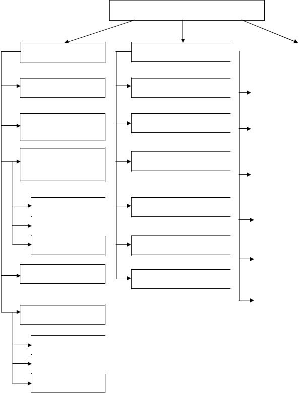
Regarding geoiconics as a science on geoimages, it seems reasonable to distinguish geoiconometry - a system of disciplines studying the general theory, methods and means of measurements according to geoimages. Three branches of metric disciplines have been distinguished (Fig. 3):
geoplanimetry - measurements of 2D geoimages; geostereometry - measurements of 3D and 2.5D images;
geochronometry or dynamic geoiconometry - measurements of 3D and 4D animated geoimages.
Geoplanimetry – the most developed branch of geoi conometry – consists of the following disciplines: cartometry, photogrammetry, morphometry (general, thematic and anamorphometry), photometry (including densitometry, microphotometry and structurometry), colorometry.
Geostereometry comprises the same measurement disciplines which are, however, referred to spatial geoimages: stereomodels, anaglyphs, block diagrams, holograms. The following branches are well-developed at present: stereophotogrammetry, stereophotometry, hologrammetry. In the future such disciplines as stereocartometry and stereophotometry, and stereocolorometry, may develop as well.
Geochronometry consists of dynamic cartometry, dynamic photogrammetry and cineholologrammetry. Dynamic morphometry, dynamic photometry and are to be developed.
The suggested classification systematizes all geoiconometric disciplines known at present, places them in order, specifies spheres of their application, points out possibilities of growth and development, and is favorable to be approached as a separate scientific branch within geoiconics.
Geoiconometric indices make up separate databases for mathematical modeling and mapping by using GIS technologies. Contemporary Earth sciences need numerous analytical and synthetic quantitative parameters which are provided by geoiconometry.
41
GEOPLANIMETRY
Cartometry
Photogrammetry
Morphometry
General
Thematic
Anamorphometry
Colourometry
Photometry
Densitometry
Microphotometry
Structurometry
Fig. 3 – System of geoiconometry
GEOICONOMETRY
GEOSTEREOMETRY |
|
|
GEOCHRONOMETRY |
|
|
||
|
|
|
|
Stereocartometry |
|
|
|
Dynamic |
|
|
|
|
|
cartometry |
|
|
|
|
|||
|
|
|
|
|
|
|
|
|
|
|
|
Stereophotogrammetry |
|
|
|
Dynamic |
|
Stereomorphometry |
|
|
|
photogrammetry |
|
|
|
||||
|
|
|
|
|
|
|
|
|
|
|
|
|
|
|
|
|
|
|
|
|
Dynamic |
|
|
|
|
|
|
|
|
|
|
|
|||
|
|
|
|
morphometry |
|
Stereophotometry |
|
|
|
|
|
|
|
|
|
|
|
|
|
|
|
|
|
|
|
|
Dynamic |
|
|
|
|
|
|
|
|
|
|
|
|
photometry |
|
Stereocolourometry |
|
|
|
|
|
|
|
|
|
|
|
|
|
|
|
|
|
Hologrammetry |
|
|
|
Cinema colourometry |
|
|
|
||||
|
|
|
|
|
|
|
|
|
|
|
|
|
|
|
|
|
|
|
|
|
|
Cinema hologrammetry |
|
|
|
|
|
|
|
42
|
ЗАДАНИЕ |
|
|
|
|
|
|
|
|
|
|
|
|
Θ |
1. Слушайте |
текст |
13, |
разделы “ Геоиконометрия” |
и |
следите за |
диктором |
по |
|||||
английскому варианту текста. |
|
|
|
|
|
|
|
|
|||||
2. |
Читайте |
английский |
вариант |
текста. |
В процессе |
чтения |
узнайте и выпишите |
||||||
ключевые слова. |
|
|
|
|
|
|
|
|
|
|
|
||
3. |
Найдите |
эти слова |
в |
словаре |
и выпишите |
их |
в |
словарной |
форме с |
тем |
|||
переводом, |
который соответствует содержанию данного текста. |
|
|
|
|||||||||
4. |
Читайте |
английский |
вариант текста еще |
раз и |
смотрите на денотатную схему к |
||||||||
тексту. |
|
|
|
|
|
|
|
|
|
|
|
|
|
5. |
Расскажите |
этот текст |
на английском |
языке, |
опираясь |
на денотатную карту к |
|||||||
тексту на английском язвке. |
|
|
|
|
|
|
|
|
|
||||
6. |
Запишите свой пересказ на магнитофон и оцените его. |
|
|
|
|
|
|||||||
43

Н. Г. Надеждина
ГЕОГРАФИЧЕСКИЕ ИНФОРМАЦИОННЫЕ СИСТЕМЫ
Учебно-методическое пособие
по подготовке к практическим занятиям по дисциплине «Иностранный язык» для обучающихся по направлению подготовки 21.03.03 Геодезия и дистанционное зондирование профиль инфраструктура пространственных данных
Федеральное государственное бюджетное образовательное учреждение высшего образования «Нижегородский государственный архитектурностроительный университет»
603950, Нижний Новгород, ул. Ильинская, 65. http://www. nngasu.ru, srec@nngasu.ru